


A post was split to a new topic: Reach RS2 Antenna Calibration Details at NOAA
Hello @andrei.kuznetcov. I have some problem with rename points in new project. I export data everyday and i see change in data.
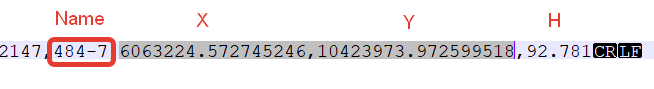
From file dayily export :
From common file now:
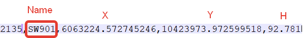
“SW901” is another point. Apps was duplicate name point and delete name “484-7”
This problem was in last time and it appeared in new project again.
P.S. We wait points name search in apps
Version Android: 10 QKQ1.190910.002
Version MIUI: MIUI Global 11.0.1 (QFGRUXM)
Model phone: Redmi Note 7 (M1901F7G)
Version app: 4.11 Beta ( we do not update before finished project)
Hi there, how to include my local vertical datum.
I’m from Portugal, we use ETRS 89 / Portugal TM06 but with the Geod PT08 vertical datum. I have it in .Tiff format and ASCII format.
If you were interested to include it on the reach 3 data base will be great. I can send you the files.
Thanks
1 Like
Hi @pvargues!
Thank you for the information!
Unfortunately, we don’t support uploading geoid files on a user side for now.
We’ll investigate a proper way to support the vertical datum you mentioned and contact you for more information if necessary.
Thank you for your help!
Hi everyone!
New ReachView3 iOS app version 4.8 Beta is released!
Here is the list of new stuff:
-
A fancy splash screen will now greet you upon opening the app!
-
The correction output settings are here! For now, you can only switch between IO channels — configuration wizards are coming in future updates.
-
We added a new vertical CRS
Latvia 2000 heightalong withlv_14.tifgeoid, which covers all Latvia areas.
-
A small yet useful update for the point info: we moved the point editing button to the top. You’ll no longer need to drag the bottom sheet up and down — all essential controls will be near at hand.
-
Minor fixes and visual improvements.
As always, waiting for your feedback!
9 Likes
ReachView 3 4.14 Beta for Android is here!
Full changelog:
- Added quick links to configure mobile data, Wi-Fi, Bluetooth, and GNSS settings via the web interface.
- You can now access the web-based logging page from the Receives tab! We tweaked a few things, and downloaded logs now can be shared using the native Android interface.
- We added a new vertical CRS
Latvia 2000 heightalong withlv_14.tifgeoid, which covers all Latvia areas
- LoRa configuration is now editable in correction output settings.
- From now on, Serial wizard won’t let to apply conflicting settings.
- We fixed a tricky case when our CSV exporter might have been confused by users switching between projects with different CRSs. Points’ coordinates will no longer be exported with the wrong number of digits after the decimal point.
@Hoehenarbeit Thank you for the report! - Minor visual updates.
15 Likes
…still waiting for manual geoid tif import… fingers crossed.
Hi everyone! New iOS app version 4.9 Beta is up for testing in TestFlight!
This release is huge for us. We have finally unlocked all device settings! We’re waiting for your feedback!
Here’s the full list of what is new:
-
Added quick links to configure your receiver via the web interface. Now you can configure all settings without leaving the app.
-
You can now access the web-based logging page from the Receives tab! We tweaked a few things, and downloaded logs now can be shared using the native iOS interface.
-
Now, it is possible to edit TCP and LoRa configurations in correction output settings.
-
We added new vertical CRSs for Slovenia, Continental Portugal, Mexico, Lithuania, and Romania:
- SVS2000 height (
EPSG:5779) and SVS2010 height (EPSG:8690)
- Portugal GEODPT08 height (
CUSTOM:GEODPT08H)
- Mexico GGM10 height (
CUSTOM:GGM10H)
- Lithuania LAS07 height (
CUSTOM:LAS07H)
- Romania MN75 height (
CUSTOM:MN75H)
- SVS2000 height (
12 Likes
It is time to check the Play Store – 4.15 Beta for Android is out!
Changelog:
- We added new vertical CRSs for Slovenia, Continental Portugal, Mexico, Lithuania, and Romania:
-
SVS2000 heightandSVS2010 heightalong withsloamg2000.tifandsvs2010.tifgeoids
-
Portugal GEODPT08 heightalong withgeodPT08.tifgeoid
-
Mexico GGM10 heightalong withGGM10.tifgeoid
-
Lithuania LAS07 heightalong withlit15g.tifgeoid
-
Romania MN75 heightalong withEGG97_QGRJ_SfASCII.tifgeoid
-
- Added quick access to the Base mode settings via the web interface.
- Mobile data, Wi-Fi, Bluetooth, and Camera control now display their statuses on the main settings screen.
14 Likes
Yes!
2 Likes
That is great news! Hope to see final release soon. Thank you so much for your hard work.
5 Likes
Did you ever get an answer to this?
@egor.fedorov Until RV3 supports on the fly base correction from WGS84 to whatever reference system the Rover uses, should we keep the Base in WGS84 as well as the Rover?
I guess I want to confirm how best to use NTRIP. I am going to use an example datum of NAD83 for clarity:
-
Keep both Base Unit and Rover Unit in WGS84 (because on the fly corrections from the Base Units datum to the Rover Units Datum have not yet been implemented)
-
Take a known point that is in NAD83 coordinates for the base, and convert them to Lat/Long/Ht and manually enter them into the Base Unit. The Rover Unit is then set to NAD83 coordinates
If there is something I am missing or another step, or I am altogether off base your help is appreciated.
What I understood was that running the rover with a local coordinate system is possible if you run NTRIP, just not as a local base correcting the rover. Maybe with the NTRIP correcting the base as well, but I don’t understand that.
If the base is in system x, so will the rover be. Regardless of how the rover receives its correction.
1 Like
So if I want to run my state plane and geoid in Reachview 3 I just enter my state plane coordinates and Reachview 2? I could not get this to work. it was doing the same thing that we had happened in the past where if you mentionally in your a coordinate it would not fix. I’ve never had that problem again with WGS84.
2d coordinate and ellipsoid height, that should work.
4 Likes
Just ordered an RS2 for a portable base for the tractor, but this is survey stuff looking like too much fun.
RV3 its looking very handy.
10 Likes
When you can add coordinate system Pulkovo1942/CS63 zone T1,2,3?
Hi there,
Hope I can clarify some things regarding surveying in different coordinate systems with ReachView 3.
When you choose a coordinate system for a survey project, there is a hint about the base coordinate system. Like this:
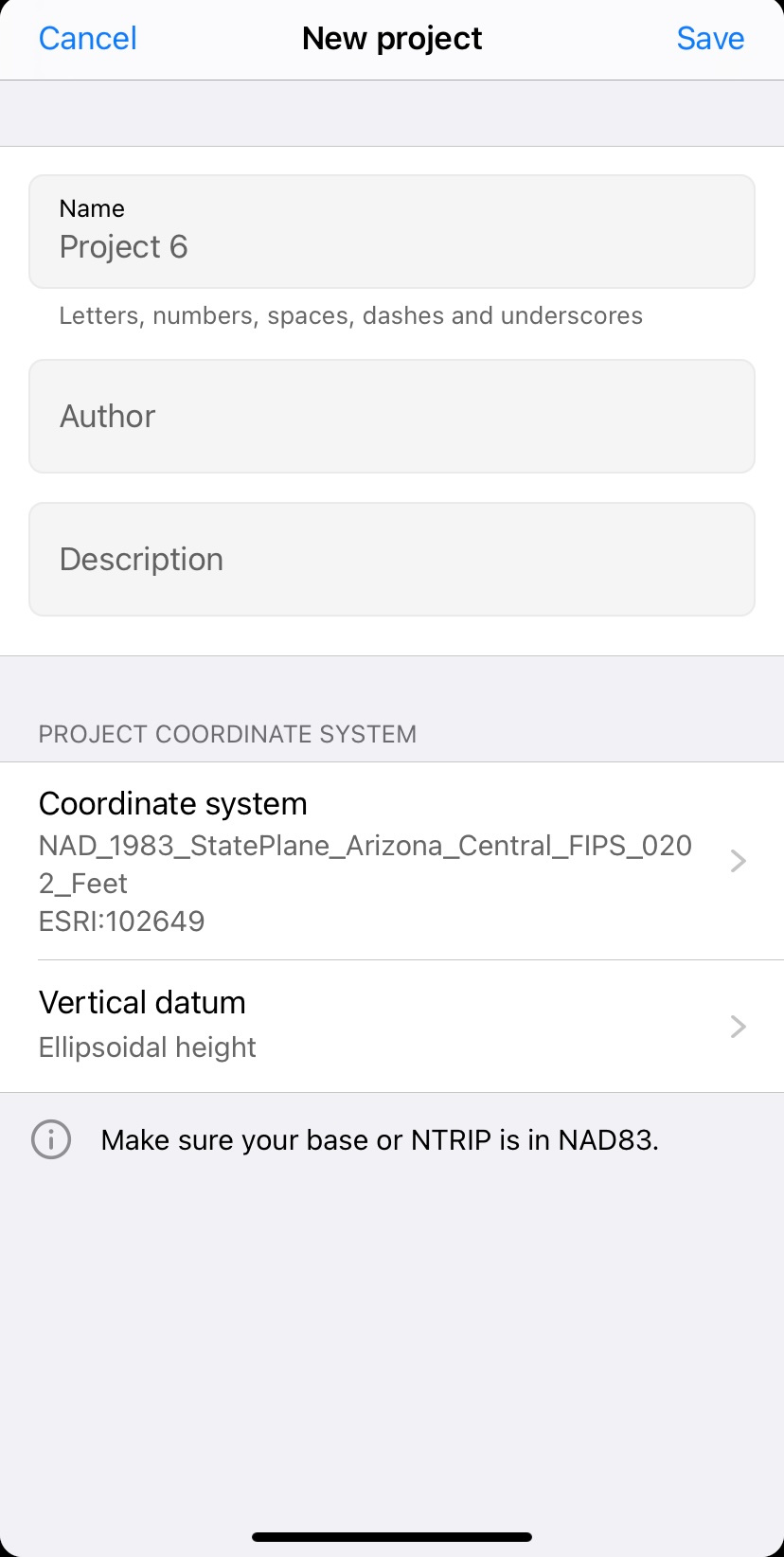
It’s usually a related coordinate system that provides geographic coordinates. Then, you have two ways:
-
Work with NTRIP caster that provides corrections in this system
-
Set up your own base in ReachView 2 if you have known point coordinates in this system. ReachView 2 can accept geographic coordinates even if it’s not WGS84 coordinates. Also, make sure you enter an ellipsoidal height above the same ellipsoid as your geographic coordinate system uses
For example, if you choose coordinate system ESRI:102649 as on the screenshot above, you can enter the base’s coordinates in NAD83 and ellipsoidal height above GRS1980 (because NAD83 is based on GRS1980) in ReachView 2. Then, you can survey in ReachView 3 and get points in ESRI:102649. You don’t need corrections from NTRIP or base’s coordinates in ESRI:102649.
Please let me know if I wasn’t clear enough or you have questions about some specific coordinate system. I’ll be glad to help you out!
To survey in NAD83, your base or NTRIP should be in NAD83 as well.
State plane coordinates won’t be accepted by ReachView 2 since they are not geographic. As far as I know, State Plane CRSs require base coordinates in NAD83, NAD83(2011), or NAD83(CORS96) depends on the modification you use.
7 Likes
Hi Andrey,
We may consider adding the required coordinate systems. However, it seems we need some additional details from you. Would you mind sharing them?
Did I get correctly these coordinate systems don’t have EPSG codes?