


OK I’m hoping you might be able to give me some clarity while using ReachView 3. If I am solely working in ReachView 3 via Ntrip and my Ntrip service is only running on NAD 83, 2011 with ellipsoid heights is that the only thing that I can use in ReachView 3 when collecting gcps? Or if I select another with a vertical height like NAVD88 applied to it will ReachView 3 automatically make the adjustments based on the geoid?
Hi Seth,
Yes, you can work with NAVD88 heights in ReachView 3, if your NTRIP caster provides corrections in NAD83(2011) with ellipsoidal heights.
1 Like
Sorry to be such a pain but I wanna make sure I’m understanding 100%. So RV3 makes the adjustments for me in the app? Even though my NTRIP provider only has ellipsoid heights, selecting NAVD vs Ellipsoid in the app, the app will do all the hard work?
Yes, you’re right.
I’m here to help you! Don’t hesitate to ask questions 
1 Like
Thank you so much. What is the difference between NAVD88 Depth vs Height?
Depth is used normally for bodies of water/bathymetric. This is the best explanation I have seen.

One z-value is shown for the height-based mean sea level system. Any point that falls below the mean sea level line but is referenced to it has a negative z-value. The mean low water system has two z-values associated with it. Because the mean low water system is depth-based, the z-values are positive. Any point that falls above the mean low water line but is referenced to it has a negative z-value.
3 Likes
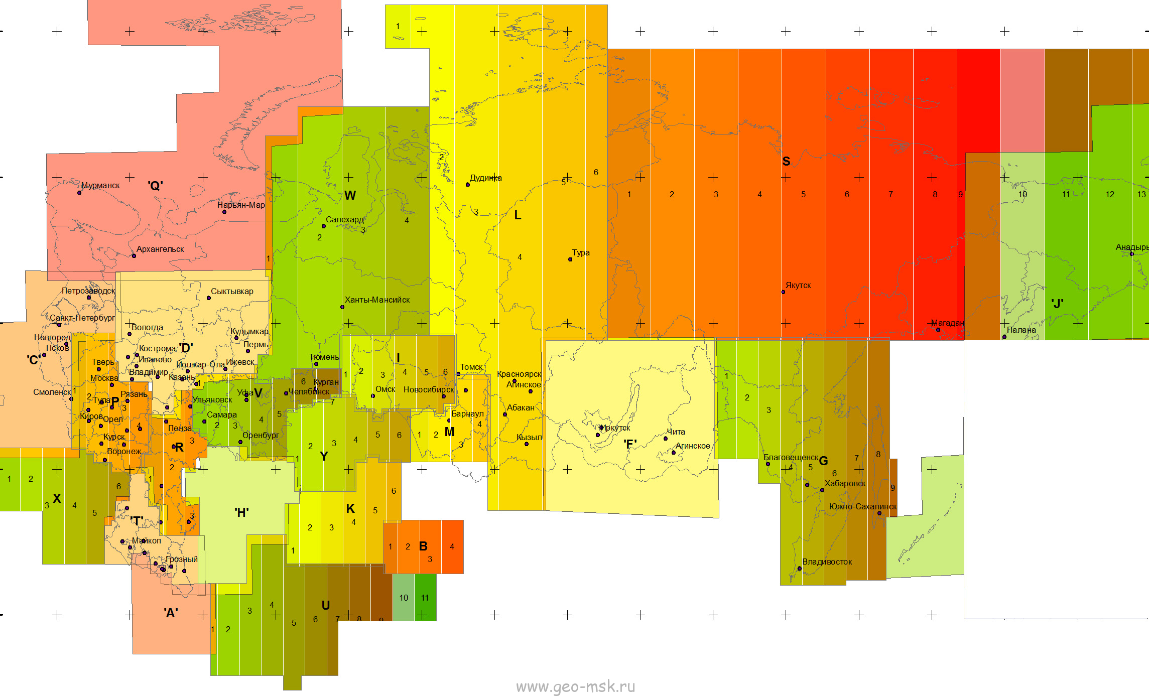
According to the picture, there are several zones in the coordinate system of 63 years. The reach view has coordinate systems for some of them. I am interested in zone T. I don’t know which EPSG code corresponds to this zone, but I know the parameters.
Why do i need this zone? Because local coordinate systems my region are based on it, which you are unlikely to add in the near future, but you need to work somehow.
Here is a link to the parameters of the local coordinate systems Местные системы координат suddenly hands will reach
2 Likes
Agree with Michael. This system has the main axis oriented downward to work with positive z-values for depths.
Andrey,
Thanks for the additional info and the request. Yes, we can hardly implement this system at the nearest time. However, in one of the future releases of ReachView 3, it will be possible to add local coordinate systems by parameters. I believe it should help you out.
4 Likes
Hi everyone!
New ReachView 3 5.0 Beta for iOS is out!
Here’s what to test in the new release:
-
We added new vertical CRSs for Argentina and Brazil:
-
SRVN16 heightalong withGEOIDE-Ar16.tifgeoid
-
Brazil MAPGEO2015 heightalong withMAPGEO2015_sirgas.tifgeoid
-
-
Notification about new Reach firmware update has been added to the device settings screen, so you do not miss out on new functionality.
-
Now, devices with a firmware version lower than 2.24.0 need to be updated to work with ReachView 3.
-
Correction output settings are fully available! We unlocked the NTRIP option and added the possibility to edit Serial configuration too.
-
The device scanner now shows more verbose errors and allows you to do the first setup or update receivers directly from the app.
-
Updated the grid required by
Romania MN75 heightCRS as the previous version caused incorrect height transformations. Existing projects won’t be affected, but you’ll need to download the new file. Be advised that exported CSVs are prone to have erroneous height values. -
Removed CRSs
DHHN2016 heighandLHN95 heightdue to license issues. Existing projects will continue to work correctly, but you will be unable to use said systems for the new ones. -
Minor fixes and visual improvements.
12 Likes
ReachView 3 version 5.0 Beta for Android is here too! This update offers some cool new features, and we can’t wait for you to check out all of them.
Be advised that devices with firmware lower than 2.24.0 need to be updated to work with this version.
Changelog:
-
Added a view with device status data! Coordinates, solution status, DOP, info about corrections, you name it. You can access the device status overview page anywhere in the app by clicking on the status bar.
-
The last piece of correction output settings is here — the NTRIP option is now unlocked.
-
General settings are now fully unlocked. “Firmware updates” and “Device and hotspot name” are accessible via the web interface, starting with the 2.24.1 firmware version.
-
The device scanner now shows more verbose errors and allows you to do the first setup or update receivers directly from the app.
-
Notification about new Reach firmware update has been added to the device settings screen, so you do not miss out on new functionality.
-
Added new vertical CRSs for Argentina and Brazil:
-
SRVN16 heightalong withGEOIDE-Ar16.tifgeoid
-
Brazil MAPGEO2015 heightalong withMAPGEO2015_sirgas.tifgeoid
-
-
Updated the grid required by
Romania MN75 heightCRS as the previous version caused incorrect height transformations. Existing projects won’t be affected, but you’ll need to download the new file. Be advised that exported CSVs are prone to have erroneous height values. -
Removed CRSs
DHHN2016 heighandLHN95 heightdue to license issues. Existing projects will continue to work correctly, but you will be unable to use said systems for the new ones. -
Minor visual updates.
-
Various fixes and improvements.
14 Likes
Hope to see an important feature “Base Shift” that can change Rover’s coordinates to align (in real time) with an existing BM which is NOT in alignment with Base’s coordinates. Thanks
4 Likes
The CSV format (UTC time and day) that is equal to RV2 to be able to use the point extractor.
I would appreciate if you can modify it.
Thank you
4 Likes
Hi Dapo,
Which dealer did you get your reach unit from in Nigeria, I would like to know what kind of Survey workflow u carry out, Cadastral, Construction or…,if chanced I would like to provide you with a CORS in Lagos to Demo for a brief period.
Thanks, from Argentina
2 Likes
Hi Michael,
Didn’t know FieldGenius Android supports Emlid GNSS Receivers.
5 Likes
I have request. Import coordinates manually. Very useful in stakeout if you forgot to upload
8 Likes
For sure. There is a driver and model selection specifically for the RS2 that has the calculations built in for the phase center.
3 Likes
for this case i have a stakeout.csv-Projekt, where i can type the coordinates with texteditor. Then i have it in my project-list for stakeout. But for sure it would be nice to add coordinates in the Project directly with"Add point" 
Im so sorry, that you removed dhhn2016. 
What about to add it manually?
2 Likes