


At least could you add the HTRS07/TM07 projection that doesn’t need any grid files? There is a tool that transforms the HTRS07–>GGRS87.
Here in Greece the official system is the GGRS87 but they moved to a new system the HTRS07 and all the public and private COORS are bound to this reference system.
Thanks again…
1 Like
Ayas,
Base mode will be available in one of the upcoming releases, the workaround for now is to switch to ReachView 2 (like here).
2 Likes
thank you egor it will be very useful you make Auto survey
1 Like
1- Is it possible to create stake out lines in the Reachview 3?
2- It would be interesting import/export another formats, like shapefiles, dxf, etc.
2- Other idea in another versions is create check box to switch a layer background, like google earth imagery. Is it possible? makes fieldwork much easier
3- In stake out, it would be interesting to shows the direction of the arrow all the time, without the need to move the gps.
5 Likes
Is there a way to use your own geoid files in ReachView3?
Unfortunately we are just outside the “current ReachView geoid limits of Germany”. But since we acquired the geoid data from the BKG, it would of course be great if we could use them.
EDIT: Just found the note above… We would appreciate this feature 
3 Likes
1- the most important
2 Likes
Hello everyone! New iOS app version 4.7 Beta is out!
Here’s what to test in the new release:
- We added support for a bunch of new vertical coordinate systems ! This update includes CRSs for Austria, New Caledonia, Balearic Islands, Canary Islands, Ceuta, Alicante, and Slovakia.
-
GHA heightandEVRF2000 Austria height(Austria) -
NGNC08 height(New Caledonia) -
Mallorca height,Menorca height, andIbiza height(Balearic Islands) -
Lanzarote height,Fuerteventura height,Gran Canaria height,Tenerife height,La Gomera height,La Palma height, andEl Hierro height(Canary Islands) -
Ceuta 2 height(Ceuta) -
Alicante height(Alicante) -
Baltic 1957 height,Baltic 1957 depth, andEVRF2007 height(Slovakia)
-
- We changed the default base CRS for some coordinate systems used in New Caledonia, Slovakia, and Romania.
-
RGNC91-93is now used as a base CRS forIGN56 Lifou,IGN53 Mare,ST84 Ile des Pins,NEA74 Noumea,IGN72 Grande Terre, andST87 Ouvea(New Caledonia) -
ETRS89is now used as a base CRS forS-JTSK(Slovakia) -
ETRS89is now used as a base CRS forPulkovo 1942(58)(Romania)Now, using CRSs that are based on these systems involves datum transformations with a horizontal grid or by transformation parameters.
-
- The EPSG list was updated in accordance with the EPSG v9.8.12 and ESRI v10.8.1.
- The Sound settings for your Reach RS2 devices are unlocked!
- The ‘Can’t find Reach?’ hint on iOS 14 was updated to include information about local network access permission.
- Prevented the system from deleting downloaded geoids/grids while trying to automatically free-up device storage.
11 Likes
My Android says i’m on 4.13 Beta. So what is exciting new? 
5 Likes
The Android app reached version 4.13 Beta!
@Nordstern It’s nice to know that our users are always up-to-date!
This update contains a lot of improvements to the UX:
- Survey project wizard became smarter, and now it remembers the last used CRS setup.
@a.hopfer Can this feature replace the explicit setting of a favorite system? - We made the map reading easier by adding a scale bar to it.
- Now, map controls are non-transparent so that underlying content won’t interfere with their content’s visibility.
- A small yet useful update for the point info: we moved the point editing button to the top. You’ll no longer need to drag the bottom sheet up and down — all essential controls will be near at hand.
- Various fixes and improvements.
- Minor visual updates.
10 Likes
Thank you Andrei (and Team).thats exactly what i want. 

8 Likes
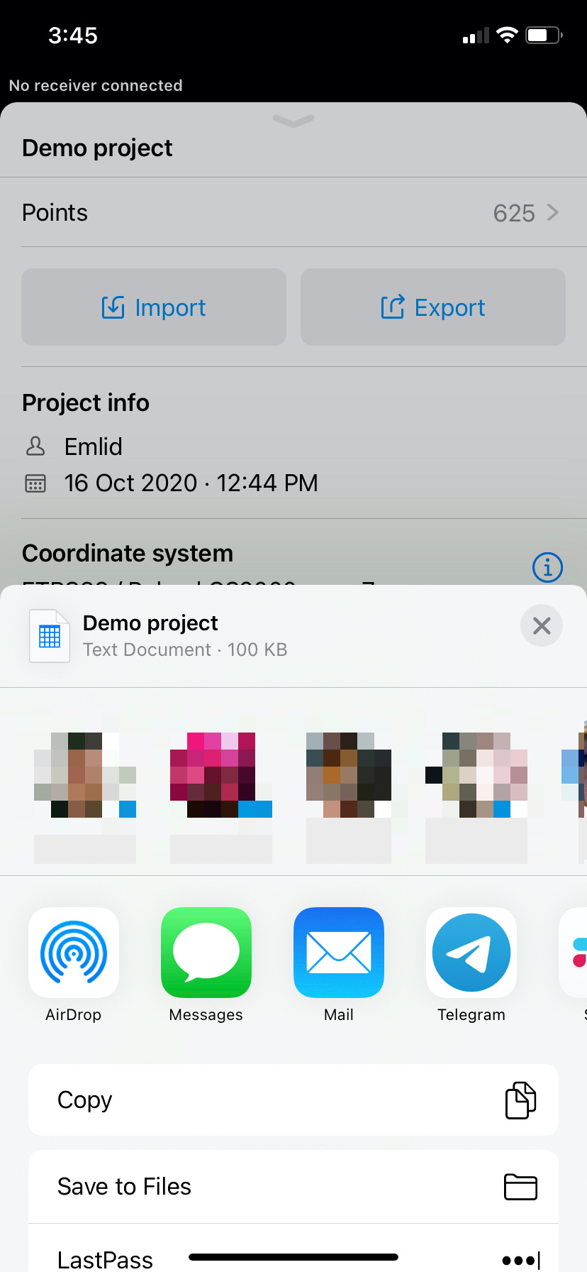
Is it possible to add the “author” and “project description” to the csv-file, or how do I keep this information with the data/points when exporting a project?
How do I do so that when I export a project in .cvs it stays in the internal memory of the phone and not that it asks me to send it to the cloud or by mail?
An additional message.
If you’re using the iOS app, choose the “Save to files” option in the sharing menu.
Please, always specify the platform and app version – this helps to solve issues much faster!
2 Likes
If is possibleI want a “csv” file model that can be imported into an EMLID 3 project.
1 Like
I just tried out ReachView 3 with the RS2 and already found a bug when creating multiple surveys with different coordinate systems. When exporting the csv only 3 decimals of the coordinates are written to the file.
To reproduce first create a survey with a coordinate system in which the coordinates are in degrees and afterwards crate one where they are in meters. Now export a csv of the first survey and you will only see 3 decimal points in the coordinates.
2 Likes
Hi David!
Thank you for the report! Can you please specify the platform and app version you were using?
Hi!
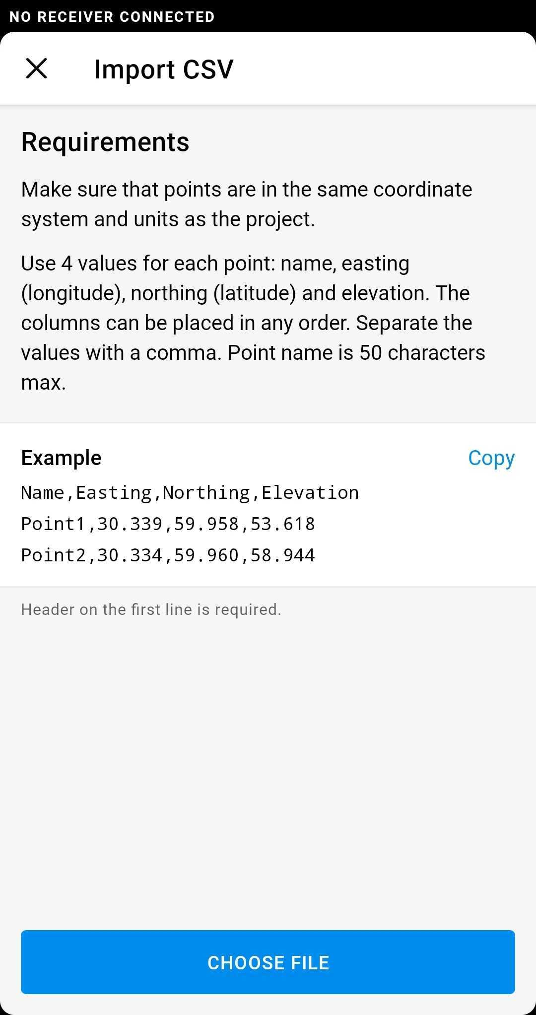
Here is an example of the minimum data set to be imported:
Name,Easting,Northing,Elevation
Point1,30.339,59.958,53.618
Point2,30.334,59.960,58.944
There is instruction before choosing a CSV file – you can check the details there.
I also want to mention that the apps always try to extract all useful information from the CSV. E.g., if you try to import a CSV file created by ReachView 3, all points’ metadata will be extracted.
Thanks for the quick response. It works very well if I only have the 3 columns as your example
Another problem I noticed is about vertical datum. In Romania it is used according to the official requirements “Vertical Datum - Black Sea 1975”
The source code and the coordinate transformation application for Romania can be found here:
http://www.ancpi.ro/files/Download/TransDatRO_code_source_1.zip
http://www.ancpi.ro/files/Download/Kit_TransDatRO_4.05.zip
5 Likes
Android 10, ReachView 3 4.13 Beta
1 Like