


Hey @vgo195, absolutely the M2 is a game changer! To have a multi-band device at that price is going to change allot of games. While I am not a believer in running RTK on a drone I think it could be a possibility with the RS2/M2 combo. I’ll try it, but PPK is to easy and verifiable so it’s unlikely I will switch over unless I am doing something that doesn’t require localization.
1 Like
Thanks, I also prefer the PPK over RTK on the UAV mapping but I think a multiband receiver will be way more reliable in PPK!
I have 2 GNSS L1-L2 receivers that can work as base stations but they are only GPS-GLONASS. One from Sokkia and one from Spectra Precision.
I suppose the M2 will work with them after converting the raw files to RINEX.
2 Likes
Exactly! I get great results now 95% of the time, but the multi-band should relieve any of those week days that L1-only can experience. You should be able to use any receivers log files together as long as you can convert them to Rinex 3.03.
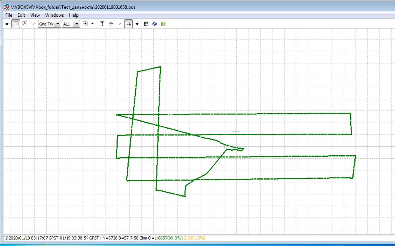
Hi,
we have tested Ublox F9P(L1+L2) with Teokit and results are very very good.
We tested it for distance - 58 km from base there is fix.
Next week we will test it for 80-100 km from base with accuracy checking…
5 Likes
Will the images be tagged with the RTK values? I assume we will still have the ability to log and PPK? If the natural state of the data looks good then we can just use the RTK values?
What combination of data recording gnss signal will be possible with new Teokit? GPS+GLO 10Hz?
1 Like
Now we are testing:
GPS + GLO + GAL + BEI - 5 hz
and
GPS + GLO + ( GAL or BEI ) - 10 hz
Results are good. Soon I will make review…
No, we use PPK only.
1 Like
Hi everyone.
We made Telegram Bot. It can convert UBX to Rinex, generate link of your DJI logs to airdata, generate link to view your LAS files.
Please use it: Telegram: Contact @TeokitBot
Las viewer example:
http://3d.teofly.com/16561336270344564416876482/
2 Likes
Yes yes!
Great discussion. I appreciate the explanation of your test flights and the results.
1 Like
Any update on a PPK step by step manual?
Would someone with years of experience be willing to give links to reference material so we can all learn without wasting countless hours reading post that dont answer our questions?
First a step by step guide to setting up the drone, flight software, emlid, and any needed gcps.
Then and the most important a list of material to learn and understand PPK.
I feel like terms are used loosely and only experienced people can make sense of what is being said.
Not looking for any handouts, just a way to cut through all the crap to get to the gold.
Thanks!
If you have no experience in any of this then you need to study, which requires time. Many of us have spent years in many facets or GNSS use and Surveying so you can’t expect us to speak in layman’s terms which is when “terms are used loosely”. GNSS PPK and processing is not a static process beyond the 5 basic steps that you can find in a thousand sources on Google and YouTube? Once you hit analysis it is more of an art as there must be creative problem solving and familiarization with the softwares. There’s no better way to learn it than to use it. Keep backups if your data so you can play without fear of consequences.
- Configuration
- Collection
- Processing
- Analysis
- Application
You need to have a direction and goal before anyone here can help you. One of the basic questions you will always get asked is… What is the purpose of your use of PPK?
I agree 100%. Research is what I’m (hoping others as well) are after.
I’m assuming most everyone has gone to school or was taught by someone on the job.
Everyone else (myself included), self taught, and would benefit from references or some good terms to google/YouTube to get to the better research.
“Loose terms” I should have explained more. Side overlap vs transverse as an example. But if google transverse overlap for photogamatry is beneficial then that’s a good term to use.
Step by step guides are only needed from the manufacturer of a product (like here it’s already been mentioned a PPK guide to toolbox will be produced). Basicly how to apply the use of all this knowledge from research to a specific goal.
I left my goal out of it for the main reason of have a wide range of info available that pertains to this topics. And most specifically the reffered to manual of the PPK process other than emlid recent one.
Still not clear what your purpose is?
I’ll go through some of my resources and posts and link them here. Sorry I am going to hijack a little to get on this terminology and hope others will share.
I think allot of the verbiage is due to translation. We have to remember that on the web we are now in a global community so while some things crossover, some crossover slightly differently and even some practices don’t crossover at all. I can say that it has been pretty sweet working with all these pros. Between this and the drone forums i have had lengthy discussions with people from Brazil, the UK, Africa, China - just about all over. Here’s some of my regional verbiage.
- GNSS - The umbrella term for satellite navigation . All constellations are GNSS systems. GPS, GLONASS and etc.
- Localization (you guys see what I did there…) - A process of using record vs found control and creating a network of that found control which prorates all error and allows for analysis and removal of bad points. It quickly became apparent that this is something we do in the States, particularly in construction that others don’t.
- Relative Accuracy - How closely a group of points relate to each other in comparison to previously documented points.
- Absolute (Global) Accuracy - How close a measured point is to a previously documented point.
- Overlap (drone, front/side) - Pretty obvious, but not as fancy as Transverse
- Tangent (drone) - Sometimes called the leg, but more common as the line coming into the corner since more drones now using a drifting (curved) motion through corners.
- Leg (drone) - Multi-battery mission 1 vs 2, etc
- Monument - Typically horizontal control such as property pins or ROW disks. 1st generation (to us).
- Benchmark - Typically vertical control only, but these do get crossed up. 1st generation (to us).
- Control Network - 2nd generation points staked specifically for high visibility.
- Traverse - Not to be confused with Transverse. Typical Survey term for 2nd or 3rd generation control points that are used to move across land.
- Vertex (Vertices) - Points on a line, more specifically a change in direction in X, Y or Z. Otherwise it is just a POL.
1 Like
We are developing now step by step manual. But it is very difficult to put all things of photogrammetry to the “paper”.
Soon I will start to post info here.
1 Like
I started a new thread for us to dump the most relevant data to PPK use.
That is very encouraging!
I look forward to it!
Thanks!
Hi Konstantin, it seems that your last product is handling directly the F9P chip without M2. Am I right ? Also I am confused between Teodrone and Teokit relationship.
Hello.
We made our own L1/L2 board like Reach M2, but designed special for DJI Phantom 4 adv/pro.
I will not write about it here, because this forum is emlid owned.
About Teokit and Teodrone:
Teodrone and Teokit are trademarks of Vanavara Digital company which cofounder and CEO I am.
2 Likes