Right now you can just switch from stakeout to collect by closing the stakeout mode and tapping the big + button. I know it’s not as fast, but it should get the job done.
At the moment we are focusing on coordinate system support and full Reach configurations. Serious surveying improvements should start coming after this.
Thanks for the suggestion, though. It’s been added to our idea backlogs.
Is there a way in the CSV export of putting the corrected height into the download file? RMS rather than just ellipsoid height? Im using WGS 84 and ODN height. But CSV only has geographic coordinates.
There are some important changes you should be aware of before updating:
Now devices with a firmware version lower than DEV 2.23.7 need to be updated to work with ReachView 3.
Now all geoid and grids use .tif format instead of .gtx and .gsb. Previously created projects may ask to re-download grid/geoid files. Sorry for the inconvenience.
And here is the full changelog:
Updated the EPSG systems list in accordance with the EPSG v9.8.9.
Added CRSs
Horizontal:
EPSG:9248(Tapi Aike)
EPSG:9251(MMN)
EPSG:9253(MMS)
EPSG:9294(ONGD17)
EPSG:9333(KSA-GRF17)
EPSG:9249(Tapi Aike / Argentina 1)
EPSG:9250(Tapi Aike / Argentina 2)
EPSG:9252(MMN / Argentina 2)
EPSG:9254(MMS / Argentina 2)
EPSG:9265(POSGAR 2007 / UTM zone 19S)
EPSG:9271(MGI / Austria West)
EPSG:9272(MGI / Austria Central)
EPSG:9273(MGI / Austria East)
EPSG:9284(Pampa del Castillo / Argentina 1)
EPSG:9285(Pampa del Castillo / Argentina 3)
EPSG:9295(ONGD17 / UTM zone 39N)
EPSG:9296(ONGD17 / UTM zone 40N)
EPSG:9297(ONGD17 / UTM zone 41N)
EPSG:9311(NAD27 / US National Atlas Equal Are
ESRI:53025(Sphere_Hotine)
ESRI:53048(Sphere_Times)
ESRI:53075(Sphere_Wagner_V)
ESRI:53077(Sphere_Natural_Earth)
ESRI:53078(Sphere_Natural_Earth_II)
ESRI:53079(Sphere_Patterson)
ESRI:53080(Sphere_Compact_Miller)
ESRI:54025(World_Hotine)
ESRI:54048(World_Times)
ESRI:54077(World_Natural_Earth)
ESRI:54078(World_Natural_Earth_II)
ESRI:54079(World_Patterson)
ESRI:54080(World_Compact_Miller)
ESRI:102038(The_World_From_Space)
ESRI:102061(Everest_Modified_1969_RSO_Malaya_Meters)
ESRI:102096(Bab_South_Palau_Azimuthal_Equidistant)
ESRI:102163(Lisboa_Bessel_Bonne)
ESRI:102237(Pohnpei_Az_Eq_1971)
ESRI:102470(Cape_Lo15)
ESRI:102471(Cape_Lo17)
ESRI:102472(Cape_Lo19)
ESRI:102473(Cape_Lo21)
ESRI:102474(Cape_Lo23)
ESRI:102475(Cape_Lo25)
ESRI:102476(Cape_Lo27)
ESRI:102477(Cape_Lo29)
ESRI:102478(Cape_Lo31)
ESRI:102479(Cape_Lo33)
ESRI:102480(Hartebeesthoek94_Lo15)
ESRI:102481(Hartebeesthoek94_Lo17)
ESRI:102482(Hartebeesthoek94_Lo19)
ESRI:102483(Hartebeesthoek94_Lo21)
ESRI:102484(Hartebeesthoek94_Lo23)
ESRI:102485(Hartebeesthoek94_Lo25)
ESRI:102486(Hartebeesthoek94_Lo27)
ESRI:102487(Hartebeesthoek94_Lo29)
ESRI:102488(Hartebeesthoek94_Lo31)
ESRI:102489(Hartebeesthoek94_Lo33)
ESRI:102498(GOES-16_East_ABI_Fixed_Grid_ITRF2008)
Compound:
EPSG:7415(Amersfoort / RD New + NAP height)
EPSG:3903(ETRS89 / TM35FIN(N,E) + N2000 height)
EPSG:3901(KKJ / Finland Uniform Coordinate System + N60 height)
EPSG:3902(ETRS89 / TM35FIN(N,E) + N60 height)
EPSG:7409(ETRS89 + EVRF2000 height)
Horizontal:
EPSG:4001(Unknown datum based upon the Airy 1830 ellipsoid)
EPSG:4002(Unknown datum based upon the Airy Modified 1849 ellipsoid)
EPSG:4003(Unknown datum based upon the Australian National Spheroid)
EPSG:4004(Unknown datum based upon the Bessel 1841 ellipsoid)
EPSG:4005(Unknown datum based upon the Bessel Modified ellipsoid)
EPSG:4006(Unknown datum based upon the Bessel Namibia ellipsoid)
EPSG:4007(Unknown datum based upon the Clarke 1858 ellipsoid)
EPSG:4008(Unknown datum based upon the Clarke 1866 ellipsoid)
EPSG:4010(Unknown datum based upon the Clarke 1880 (Benoit) ellipsoid)
EPSG:4011(Unknown datum based upon the Clarke 1880 (IGN) ellipsoid)
EPSG:4012(Unknown datum based upon the Clarke 1880 (RGS) ellipsoid)
EPSG:4013(Unknown datum based upon the Clarke 1880 (Arc) ellipsoid)
EPSG:4014(Unknown datum based upon the Clarke 1880 (SGA 1922) ellipsoid)
EPSG:4015(Unknown datum based upon the Everest 1830 (1937 Adjustment) ellipsoid)
EPSG:4016(Unknown datum based upon the Everest 1830 (1967 Definition) ellipsoid)
EPSG:4018(Unknown datum based upon the Everest 1830 Modified ellipsoid)
EPSG:4019(Unknown datum based upon the GRS 1980 ellipsoid)
EPSG:4020(Unknown datum based upon the Helmert 1906 ellipsoid)
EPSG:4021(Unknown datum based upon the Indonesian National Spheroid)
EPSG:4022(Unknown datum based upon the International 1924 ellipsoid)
EPSG:4024(Unknown datum based upon the Krassowsky 1940 ellipsoid)
EPSG:4025(Unknown datum based upon the NWL 9D ellipsoid)
EPSG:4027(Unknown datum based upon the Plessis 1817 ellipsoid)
EPSG:4028(Unknown datum based upon the Struve 1860 ellipsoid)
EPSG:4029(Unknown datum based upon the War Office ellipsoid)
EPSG:4030(Unknown datum based upon the WGS 84 ellipsoid)
EPSG:4031(Unknown datum based upon the GEM 10C ellipsoid)
EPSG:4032(Unknown datum based upon the OSU86F ellipsoid)
EPSG:4033(Unknown datum based upon the OSU91A ellipsoid)
EPSG:4034(Unknown datum based upon the Clarke 1880 ellipsoid)
EPSG:4036(Unknown datum based upon the GRS 1967 ellipsoid)
EPSG:4041(Unknown datum based upon the Average Terrestrial System 1977 ellipsoid)
EPSG:4042(Unknown datum based upon the Everest (1830 Definition) ellipsoid)
EPSG:4043(Unknown datum based upon the WGS 72 ellipsoid)
EPSG:4044(Unknown datum based upon the Everest 1830 (1962 Definition) ellipsoid)
EPSG:4045(Unknown datum based upon the Everest 1830 (1975 Definition) ellipsoid)
EPSG:4047(Unspecified datum based upon the GRS 1980 Authalic Sphere)
EPSG:4052(Unspecified datum based upon the Clarke 1866 Authalic Sphere)
EPSG:4053(Unspecified datum based upon the International 1924 Authalic Sphere)
EPSG:4054(Unspecified datum based upon the Hughes 1980 ellipsoid)
EPSG:4280(Padang)
EPSG:4808(Padang (Jakarta))
EPSG:2163(US National Atlas Equal Area)
EPSG:3408(NSIDC EASE-Grid North)
EPSG:3409(NSIDC EASE-Grid South)
EPSG:3410(NSIDC EASE-Grid Global)
EPSG:3411(NSIDC Sea Ice Polar Stereographic North)
EPSG:3412(NSIDC Sea Ice Polar Stereographic South)
EPSG:4088(World Equidistant Cylindrical (Sphere))
EPSG:5890(JAXA Snow Depth Polar Stereographic North)
Added new vertical CRSs:
EPSG:5709(NAP height)
EPSG:3900(N2000 height)
EPSG:5717(N60 height)
Added new experimental vertical CRSs:
EPSG:5621(EVRF2007 height) (along with “ugik-geoid2011-PL-EVRF2007-NH” geoid, used in Poland )
EPSG:5729(LHN95 height) (along with “CHGEO04A” geoid, used in Switzerland ).
Changed default base CRS for all projected and compound CRSs based on geographic “CH1903+” and “DHDN” to “ETRS89”.
In some cases, projects with non-default vertical CRS could have been exported incorrectly. Now it is fixed. @excellent.geography Please check if your projects now exported correctly.
There’s a new loading indicator during the search in the coordinate system picker.
Project import was upgraded to support point metadata, like solution status and antenna height. Here’s a full list of supported headers: Easting RMS, Northing RMS, Elevation RMS, Lateral RMS, Antenna Height, Solution Status, Averaging Start, Averaging End, Samples.
The Receivers tab now offers some hints on how to find your Reach if it’s not on the list.
Now the countdown in the point collection tool saves its mode (passed or remaining time).
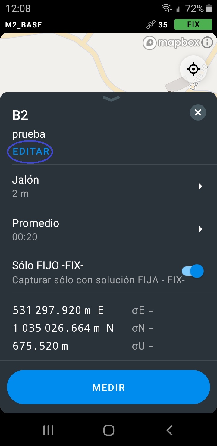
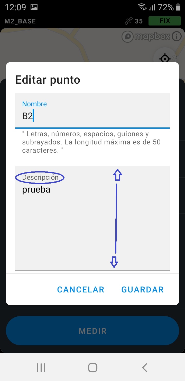
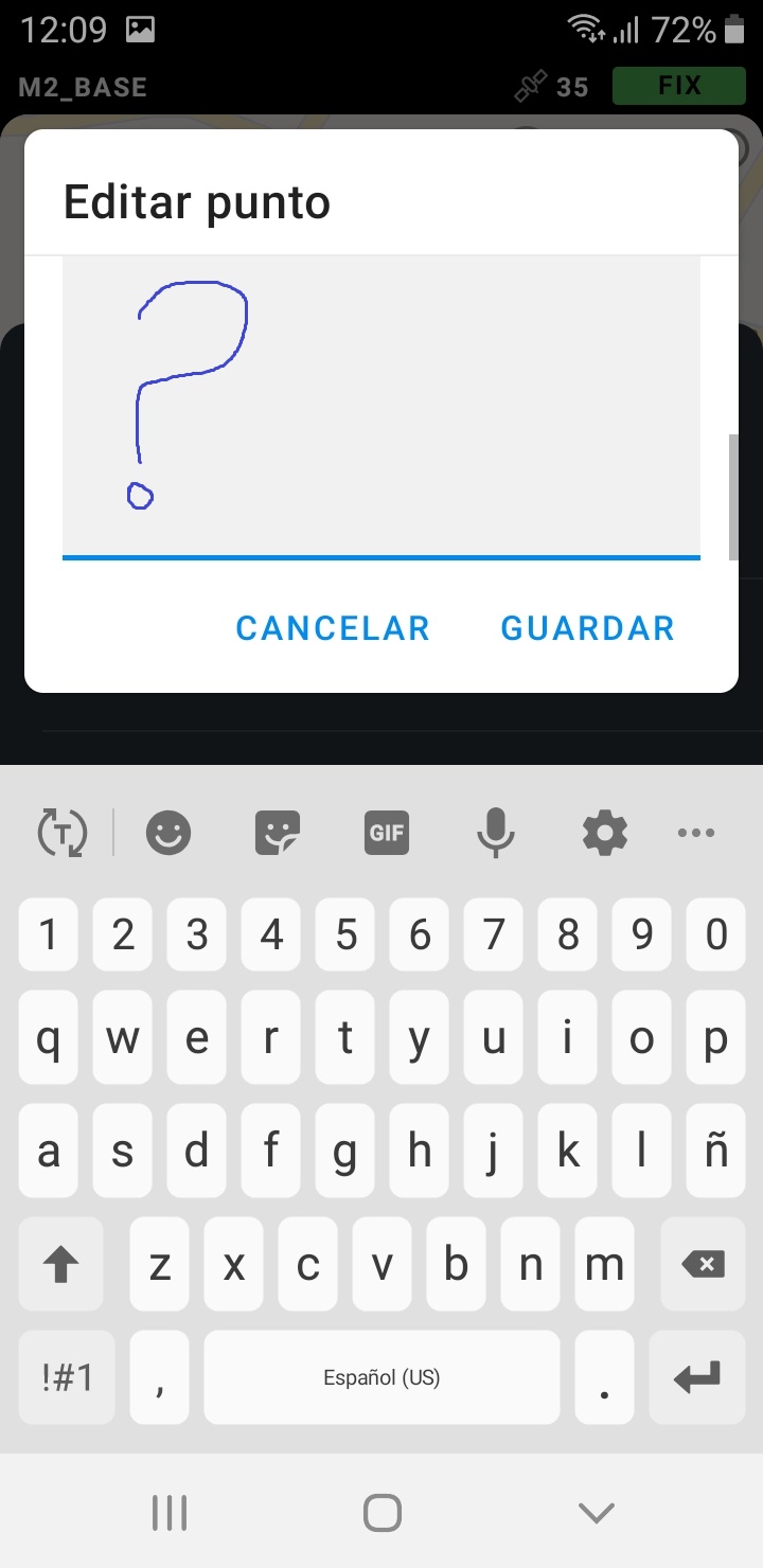
The point description edit field is very wide that does not allow the display of text for editing when the keyboard is active. Thanks for the new options.
Is it that some queries are inferior to others or emlid just decides which is important? I asked for the inclusion of EPSG 2136 for Ghana because no professional surveyor in Ghana uses EPSG 2137. No institution accepts data in that projection as well. About 5 releases has been made since then and it baffles me that all I asked was adding a projection that works for me and any user in Ghana. I’m actually disappointed because I’m here marketing Emlid. I’m currently in the process of purchasing 3 rs2 units together with an m2 from one of the distributers for a friend I’ve convinced which in all respect, I have to make sure he’ll be getting the best user experience because he’s buying them because of my word (because he already has gnss instruments from another brand he uses). Please give all queries the needed attention, especially when they are of the same magnitude as other queries you’ve attended to or plan to attend to. Thank you.
Hi! We treat all feature and coordinate system requests equally. It’s not related to magnitude of the request in any way, but rather our previous plans. We have a roadmap of new CSs we plan to support and we’ve been following it for a while now. Laying out plans and following them carefully is a big part of the reason we’ve been able ship so much CS changes in the past few releases.
When you’ve made your request we’ve added 2136 to the roadmap as a new feature like we did with all the countries before. There are two things holding us back – the countries requested before Ghana and the Gold Coast foot unit that increases the implementation complexity.
With that being said, we appreciate your effort and willingness to help with the testing and we’ll try to move 2136 support forward.


 )
) ).
). to “ETRS89”.