We have been testing the device for two weeks and can only agree what was said before - amazing device with same accuracy as the RS2, also in forests. However you have to be careful if you don’t have a fix status (like with any GNSS receiver).
What we encountered though, is that sometimes when connecting via bluetooth to a third party app (Qfield) the ntrip connection is lost after some time. After removing and adding the BLE ntrip connection in reachview app it woks again. Anybody had the same issue?
We have been testing the device for two weeks and can only agree what was said before - amazing device with same accuracy as the RS2, also in forests.
Sounds wonderful! Thanks for sharing your experience.
What we encountered though, is that sometimes when connecting via bluetooth to a third party app (Qfield) the ntrip connection is lost after some time. After removing and adding the BLE ntrip connection in reachview app it woks again.
Does anything unusual happen before the connection is lost? How much time passes before that? Can your Reach RX start receiving NTRIP corrections again in a while, or is it necessary to reconnect it manually?
If you haven’t tried to set the correction input and Mock location in the Lefebure NTRIP Client, please let me know if it changes anything. You can find the step-by-step workflow in our docs.
In case it doesn’t help, please share a bit more info about the setup:
Is the ReachView 3 app updated to the latest version?
What’s your mobile device model and OS version?
Do you use a local base or an NTRIP service? If it’s a service, please tell me which one you use.
I had similar issues with corrections being lost while using the RX in Puerto Rico a few weeks ago. I don’t think the issue was with the RX, I believe it was with my NTRIP correction service the Puerto Rico Seismic Network (PRSN) real time GNSS service. I could get a FIX when I had a clear view of the sky but not when I was near any trees. I think the corrections kept timing out as the age of the corrections would keep increasing up to 1 minute and then stop. I think the second issue was that the PRSN NTRIP service was only providing correction data for approximately 9 satellites while the RX could see almost 40 total satellites.
I eventually set up my RS2+ on one of the points that I established with the RX, and then used the Lora antenna and my RS2 as the rover. With this combination I had only one point where I couldn’t get a FIX and that point was over a meter below a concrete aqueduct. I have not had a chance to try this test in a controlled environment but hope to do so in the next month.
Hi Hartl, on the very first test using the RX together with QField we see that the “Quality” reading in the positional information in the QField App is flickering between Fixed RTK and DGPS. In Reach View 3 App it looks stable.
I guess it is more a QField Issue than a problem on the RX side.
Yeah we also encountered the switching between Fixed RTK and DGPS. However, after some time, the RX loses the Fix and the position jumps several decimeters to meters. Then I have to open Flow, go to settings and select the correction input another time in order to establish a fix again.
Just wanted to quickly update this thread as we have been in touch with @hartl.consulting via email over this case.
To keep the connection stable, please set up both the NTRIP settings and the position output in the same app. If you plan to survey with Emlid Flow, you can set up the NTRIP directly in it.
However, if you’re working with the third-patry apps, it’s important that you set up the NTRIP connection through them or the Lefebure app. It’s possible you lose the corrections while working in the third-party app because you create a correction link in Emlid Flow and then push Emlid Flow to the background mode. Setting up the NTRIP directly in the app you survey in or in Lefebure will help you to avoid the situation when the corrections are dropped and the solution is lost.
I believe these tutorials with a step-by-step explanation of how to work with third-party apps and Reach RX can be helpful:
Thanks for summing it up @polina.buriak
I just wanted to give a quick heads up of what I found out.
Some Apps have issues getting the location transmitted correctly from Leafbure NTRIP Client (for example ArcGIS Field Maps or Quick Caputre). See also this thread: Reach RX and Field Maps on Android - #5 by julia.shestakova
With an old version of ArcGIS Field Maps (called ArcGIS Collector) it worked properly though. I am talking to the ESRI team to find out more about this.
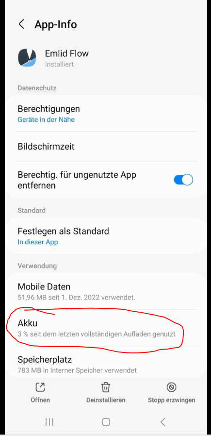
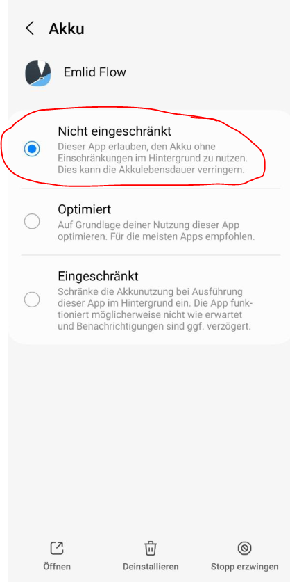
However, I found a solution to connect with the RX directly in the app without losing the fix (and the connection to Emlid Flow in the background). Therefore, the battery settings of Emlid Flow app have to be changed. This can be done in the Android Settings → Apps → Emlid Flow → Battery → Set mode to “Not optimized”
See also following screenshots (in German Though):