I am wondering what version of rinex, and what hz rate to use for submission to nrcan.
Trying to get my latest cellular base location for farming dialled. I know i do not need absolute accuracy for farming, but I am having fun learning about surveying.
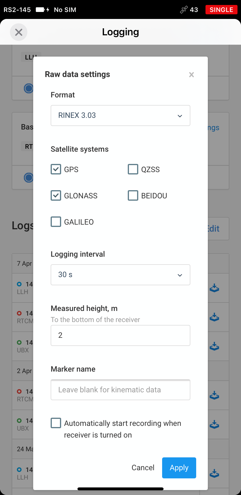
I read the reach instructions and it said only use gps and glonass, so i take it nrcan just does not track beidou and Galileo.
It also said to use 1hz observations, is there any benefit faster or slower rate? How much more accurate does longer observation time make the measurement?
Of course when I want to do this a big storm rolls through will start making logs tomorrow.
Any reason ubx logs at the same time as Rinex on the RS2?
Thank you for all the help I will start logging tonight after work. The junk weather we are having looks like it will calm down by then. And post the step by step progress, for other PPP newbs.
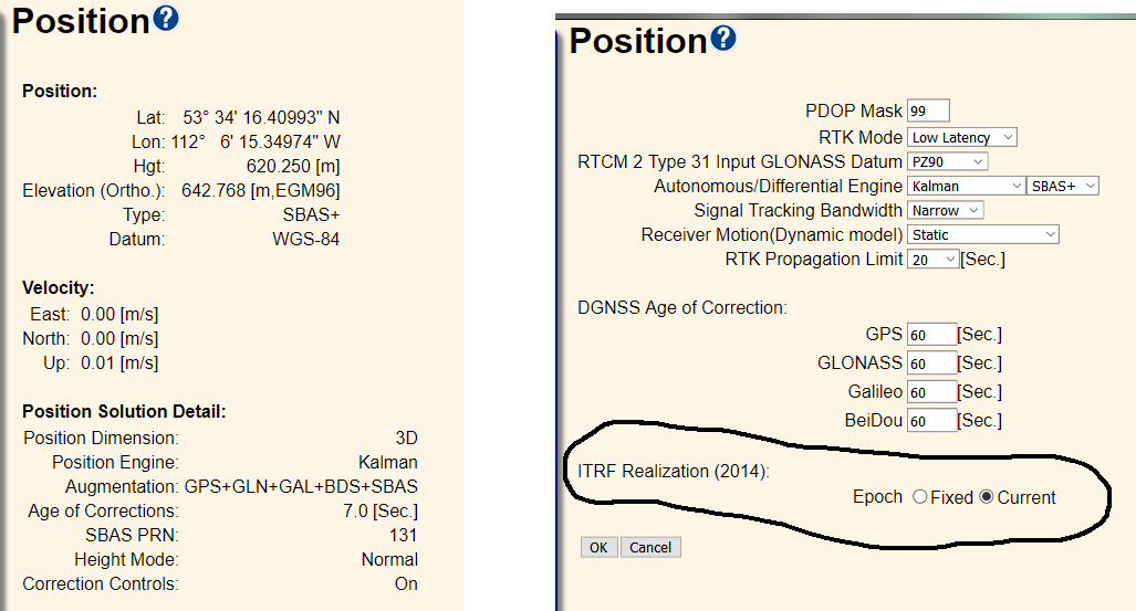
So how I think I Interpret this is my data is in IRTF14, to that datum it is this position, with sub centimetre accuracy to a 95% confidence level. Wow that was fast. So onto getting this entered into the base station.
The base is a Trimble BD970, there is no way I can find to change it from WGS84. It also has a setting for ITRF 2014 in it. I also did some reading on WGS84 vs IRTF 2014, and for the most part it sounds like its apples to apples.
I read myself to sleep last night learning about geoid vs ellipsoid.
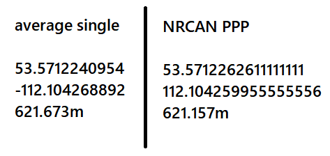
I also just surveyed in the reach position as an average single using all constellations to see how accurate that was vs PPP. I only have a Data set of 1 but it was very precise other than height.
Wow, that average single is closer than I would expect horizontally. Overall tolerance would be +/- 0.6-0.7m. Does anyone know if that is typical for a 30m average?
Just remember that this means the PPP solution has 95% of the points in the solution within that error-ellipse.
It doesn’t say much about the absolute accuracy, but something about the precision.
I have seen height differ up to 10 cm. It also down to a few millimeters, usually depending upon the quality of the raw-file. The ambiguity fixing percent seems to be important here. I have seen some very accurate solutions when the percent was 70% and some that were off by 10 centimeters when the percent was 40% (transformed from ITRF14 to ETRS89 in this specific case)
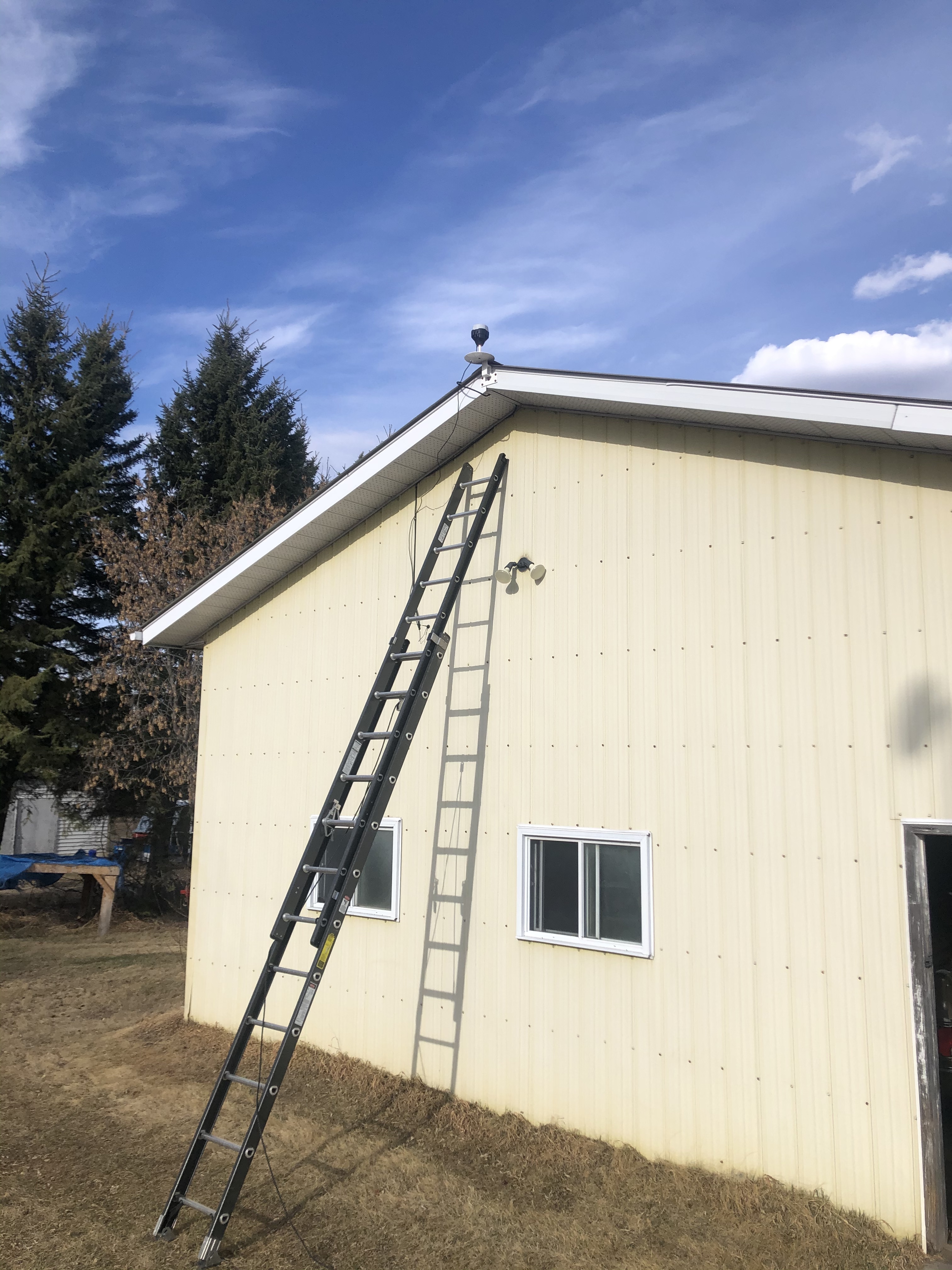
My machinery barn looks just like yours - even the same colour and window style. I’d love to locate my base just like yours, but I have 150ft high maple trees right behind it, so I don’t think it’s a good place for my base.
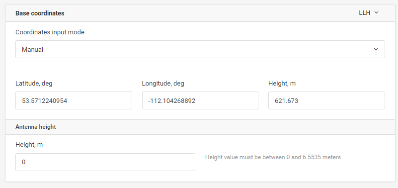
If only your base was an rs2 (or weatherized M2) you wouldn’t have to worry about the format. I just plugged in my LLH and antenna height directly and good to go. I have zero experience but my limited work suggests that the reach is awesome too!
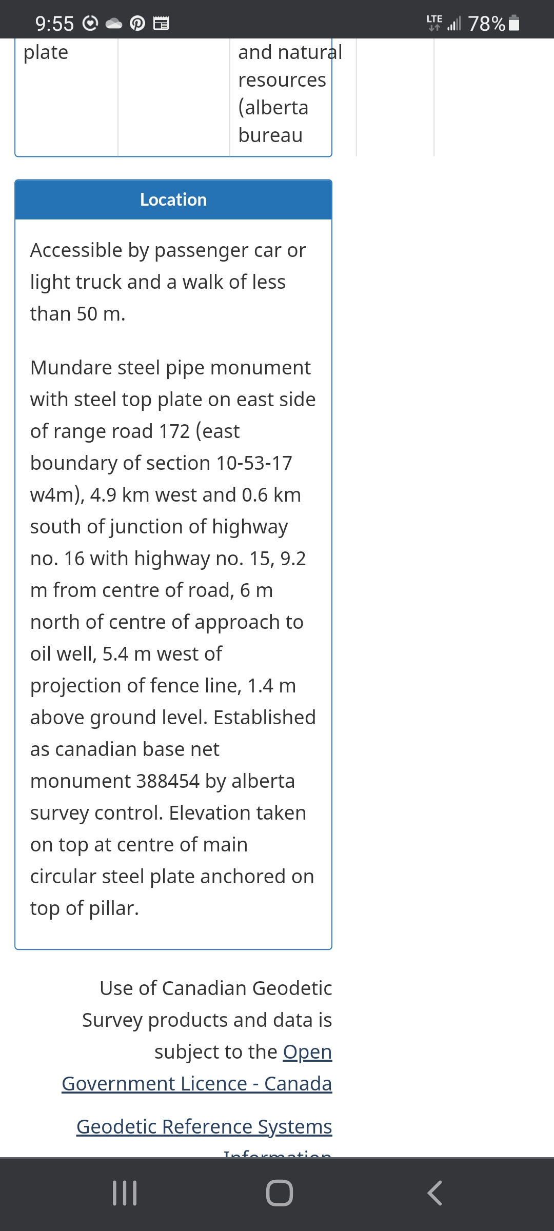
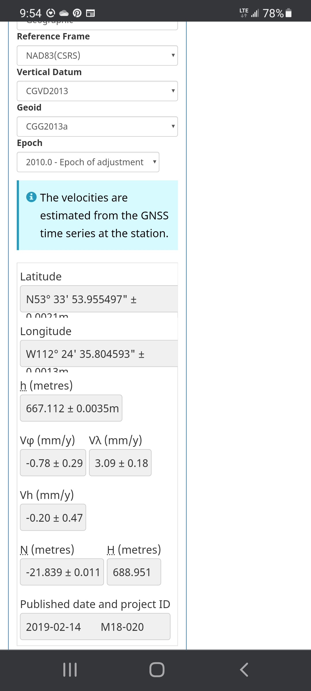
Any chance you have a maintained monument nearby? NRCan maintains a database for these monuments with exact locations that you can use to walk back to your location. It worked like a charm for me. You already posted on that thread but here is a link for your convenience. If you use their database, make sure you access it with a pc - not a smart phone.
I have not played with uploaded files or post processing yet. But I sense that we are a lot alike. It will happen soon enough.
Couldn’t resist trying to help. You have helped me immeasurably. Apparently, there is a maintained marker a few miles from you at 53.571240 -112.104270 near Royal Park. Maybe your radio can reach it without any hops? Although if it necessary a hop or two isn’t a big problem. If the method works, it is foolproof and takes away any and all doubts.
Since this is a cellular base I could verify my base by taking the RS2 to that monument and hang out for a bit. I would need to use RV3 surveying in NAD83, since Canada is based off of it.
The Trimble base is WGS84 which is super close to IRTF 2014. The Emlid also desires WGS84 corrections. The biggest Learning gained in doing this project was Ellipsoid vs Geoid and keeping your datum versions straight.
You can fix off a wrong datum and still do pass to pass guidance, wildly enough. I also learned from reading if your base position is too far in error of absolute position or using the wrong datum it increases the error due to ppm dilution as you travel further from your base drastically.
It seems I read one page, and always find a whole extra book of stuff to learn behind it.
I see. So distance isn’t a problem for you. I had been hoping LoRa might reach. Nice thing about using the Emlid products is that you can go straight to LLH and skip all the datum complications. You might consider doing that anyway. All you really want is an exact location for your Base - trimble or emlid.
Yes, I am enjoying the learning experience.
I spent most of my day making a mounting bracket for my row crop tractor and fixing a hydraulic oil leak. I’ll make a similar bracket for my loader tractor next.
Btw, I spent a long weekend in your neck of the woods a dozen years ago. I judged a dog test at a farm not too far from yours. I don’t remember exactly where, but I remember it was held at a farm that was an easy drive east of Edmonton.