All,
I’m not getting the vertical accuracy I need at a mine site using GCPs (unless I use ALOT of them).
I’m considering adding a kit to my drone to get PPK results.
Does anyone have any recommendations? I have Emlid RS2s already.
What kit do you attach you Emlid M2s to your drone with?
Has anyone tried Topodrone as well?
What are your general opinions?
I map out a large mine site for stockpile measurements, monthly.
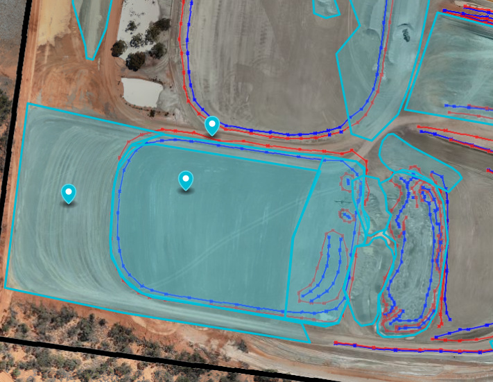
On the mine site is large drying beds, the ones in the photo are about 4ha in area, I’ve got another that is 8ha. I need the vertical accuracy to be as close to 0 as possible over this area, because obviously if it is out by 10cm for example, .01 x 40,000 = 400m3 then ± overall drone accuracy which might 3%.
I’m also getting inconsistent results for how much is pulled out of the pit depending on what I use for GCPs and checkpoint. Finally, some of my checkpoints and GCPs might be out by 10cm on the processing report (using dronedeploy).
However, if you process your DEM to your original GSD, then it makes more sense.
Also, using network adjustments and observing each point multiple times will greatly increase precision to agree where millimeter-precision using gnss is possible: Getting sub-centimeter precision with Reach RS2 and EzSurv
I think I just saw this on the DroneDeploy forum as well, lol. Not stalking, I promise… This is the detail I asked for over there.
The is the root of the problem. You need a static network of GCP’s to get the results required for a quarry/mine. Think of the site as a whole and where the GCP’s would need to be for consistent coverage. Then look at the individual areas and depending on their size place the adequate amount of sub-GCP’s. It would be best to have at least one of the root GCP’s in each area so once you have identified the individual areas you may need to slightly adjust the position of some of the root GCP’s or add a couple. The mine needs to understand that in order to have the best possible accuracy that they need to provide protected positions for static GCP’s.
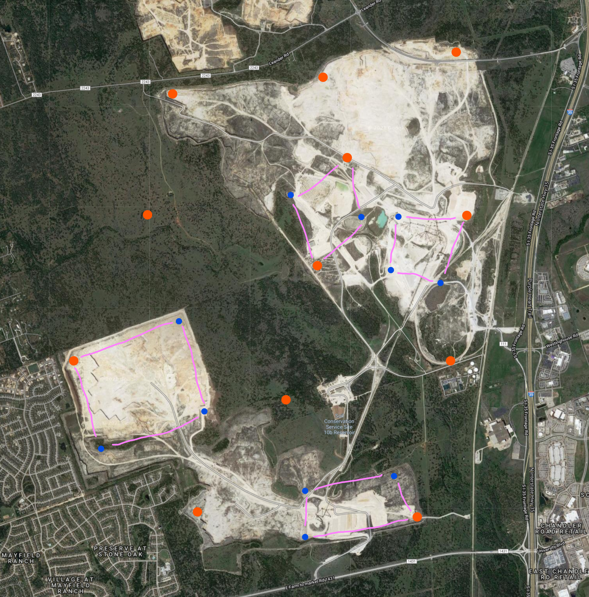
Here’s an example of a 6,000ac quarry that we map. The orange are the master site and the blue are the sub-points for the individual processing areas. That’s only 23 but the main point is that the results are repeatable every time.
Oh just for clarity these were permanent GCP’s. There was a temporary center point shot in each of the processing areas. There was no way to maintain anything in there.
That would be the only way to do it to get relatable accuracy but the site is about 15,000ft lat and lon. The easiest three points to resect and have a checkpoint are about 5,000ft apart each way. I mean for relative accuracy a good GNSS observation would be accurate enough but to get everything really tight you would need a TS or at least a level loop.
These are great answers!
I do have a collection of permanent GCPs scattered around the mine and then I drop GCPs in areas of movement too. I think I might be doing something silly though - when I set my base up everytime, I get abit nervous about it being ‘off’ and remeasure all my static GCPs again. Sometimes they are off by 7mm in X / Y / Z, but I assumed this was just the accuracy of the RS2s.
I’ve attached my flight pattern and GCP layout (permanent and dynamic). I am considering doing a single flyover as normal at 60m and another flyover of key areas at 40m, with heaps more GCPs on the beds. If a bed is 5ha, 12 acres, I would think putting four in random positions and two checkpoints would be more than enough? Thoughts?
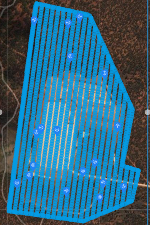
Is that the Enhanced 3D mode? First thing you need to do is get rid of the perimeter flight and just run a standard mapping mission at -90°. I wouldn’t recommend using oblique imagery and GCP’s. Especially if you want repeatability. I also see that you’ve got clumps of GCP’s and then a couple of big holes which will definitely warp a map. What was your altitude and overlaps?
This is well within the error margin of GNSS in general. You will see larger deviations from time to time.
You have to distribute your GCP’s a bit better, or surround the individual piles with a ring.
For distribution, think of a diamond shape, where (optimally) all gcp’s are at equal distance to each other. Likely impossible at a site like this.
For your checkpoints, they also need to be spaced at equal distances to neighboring GCP’s. Otherwise you won’t get a true reading.
The need for GCP’s will of course be less if you fly a PPK enabled drone, however, you still need the check-points.
Just do a single flight at 40 meters, and you should be fine.
you need more like 80/80 or more in my opinion. You probably don’t it for reconstruction (though I would never go as low as 65), but the added redundancy in imagery is great to have.
I went out and did a trail with checkpoints close to the GCPs and alot more GCPs for the area, in diamond formation with a greater overlap. I got an RMSE of 0.8cm, which I reckon is pretty great!
BUT the sheer amount of GCPs needed to do the whole mine site would kill me - so would you guys reckon that a PPK kit is the way to go?
Any recommendations on a Phantom 4 Pro V2 - I see the TUFFWING doesnt mention the V2…
The v1 and the v2 are the exact same form factor. What the Tuffwing kit doesn’t allow for is the L1/L2 helical antenna. I made my own mounting but am not seeing any great increase in accuracy with the M2 vs the M+ in the air. I also had an add-on board which powered the M2 and wrote the events instead of the light sensor but looking back on it I wouldn’t go through all the trouble again.
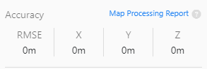
This is because you used GCP’s. It always reports 0 because the value is in meters and you GCP tagging is probably within an inch which is 0.025m so the rounding doesn’t catch it. Look at the RMSE of the camera locations and the GCP’s inside the report.