Holy cow, you went to alot of trouble! Shame you arn’t overly enthused with the final product. It happens…
SO - with your clearly massive experience, what kit would you recommend for me? The Tuffwing looks ok but its on an M+ and the antenna looks abit flimsy,
The Topodrone looks good, but it doesnt seem to use Emlid gear?
Clearly for the size of the site I would be well positioned to get a ppk kit. I’d like to order this week if possible!
While the Tuffwing kit doesn’t look as clean as the Topodrone I actually like it in the fact that it is more modular and any of the components can be easily replaced and the kit itself can be popped off in a matter of seconds. The Topodrone kit gets its power from the drone so once it’s on it’s on. The antenna mast is carbon fiber so no worries there. In my opinion if all you are doing is PPK on a drone then the M+ is plenty good. Do you have network RTK in your area?
I almost forgot about this one. A little less clean than even the Tuffwing but still modular and can use the M2. Plus it does power from the drone micro-USB.
Mounting the M2 on the drone and then PPK the M2 data will allow you to get an accurate position for each photo center. Then each photo center PPK position can be used as control point by the image processing software. With all the photo positions used as control points for aero-triangulation, you will have enough controls for the photo analysis software!
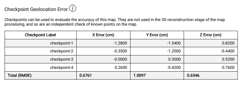
Anyhow, it remain useful to have ground control points (or ground check points). When using drone PPK you can usually reduce the number of ground points.
EZSurv post-processing software allows to PPK the M2 GPS trajectory, then, using the PPK flight trajectory curve, the position of each picture is interpolated on the curve using the photo precise time-trigger. EZSurv interpolation process also use the “GPS antenna to camera center” offset to bring calculated positions at camera center. Moreover, the delay between “time trigger and camera shutter” if any, will be taken into account (Tuffwing kit adds such delay). Finally, the interpolation process geo-tags the images with the PPK positions. Moreover EZSurv can use your Country datum and vertical surface/ortometric height when geo-tagging the images! EZSurv will help you get accurate results with almost no data manipulation.
EZSurv can also be used for conventinal surveys (ex. static ground points or kinematic surveys made with ReachView app).
NTRIP is for RTK so not necessarily. What you will need is either the logs from that source or a local base station. The RS+ is very reasonably priced and works well as a base because you can easily choose where it is placed. In Texas they will not let us connect live to RTK without a paid service but the Department of Transportation does post the hourly logs that we can correct against so I imagine you have something similar. Where are you located?
You’re set then. You can setup on a know point and manually enter that into the base or average in a point for 30 minutes, document it and enter it in manually in case you return to the same location. Note that when you do your PPK you will need to turn off L2 from the RS2 base.
@michaelL, it seems that there are some issues with powering the unit from certain Mavic 2 Pros. Not all will allow 5v out sadly. Metta says they are working on it.
Hi Joe,
I have tried a Topodrone kit for a Mavic 2 Pro. I would advise against their product since I haven’t had a good experience. The installation is easy enough, once you figure out that there’s no included user manual, just a youtube video that shows how to put it on. As far as the unit itself, it appears to be a genuine L1/L2 receiver and it connects to the Mavic and received power from the mainboard. However, the customer service experience hasn’t been great. It took some reminding to get them to ship my order. Then it turned out the cable that connects the unit to the camera and mainboard were faulty, so the drone would continually lose GPS lock. To their credit Topodrone actually reached out after this and said my cable might be bad based on the batch number. And they said they would send a replacement. That was about three months ago and I still haven’t gotten it. I reached out once since they promised the replacement and they said at the time that they would send it soon. But still no dice. Happy to chat more if you have any questions about that experience.
Andrew
Colorado School of Mines