Howdy, I recently received a single Reach GPS with antenna. Ultimately it is to be used for PPK applications on my drone. For now I am just testing it in my backyard to get a sense how good it is. To that purpose I just finished a 24hr static collect of raw data and submitted that data online to Natural Resources Canada PPP to get a corrected position. I have been doing this for years with Survey grade L1 and L1/L2 receivers to obtain positions in Northern Canada.
So … results from the Reach were DAMN good for an L1 receiver!
Note: I’m currently determining the position of the above point with a dual frequency unit so I can get the real world difference. I’ll report that later.
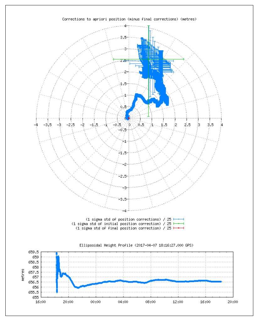
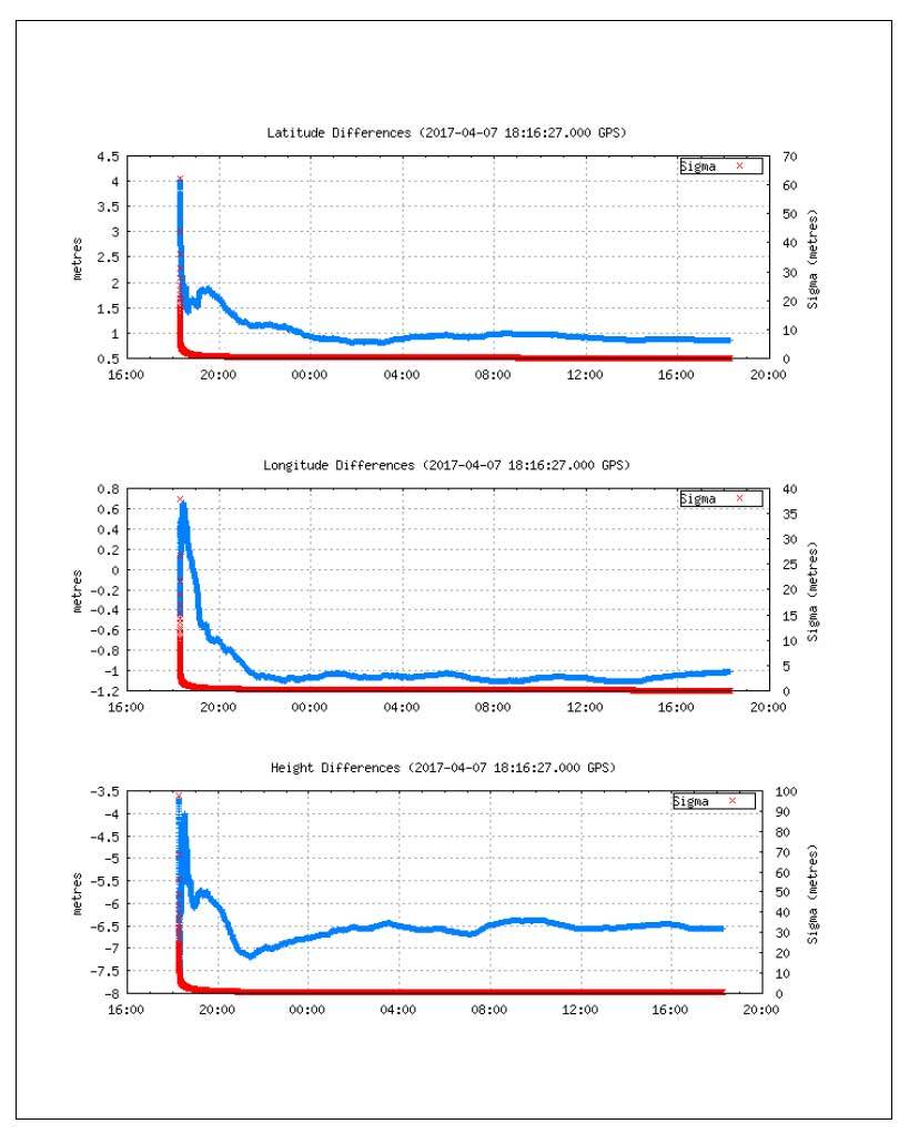
Looking at the graphs it seems that about a 6-8 hour collect is required to get an optimal result. These results are as good as anything I have got from an L1 receiver. I image a better antenna might help in reducing the number of hours needed to get optimal results. I am currently testing a $10,000+ Trimble Geo 7x (L1/L2) and PPP results are very similar (Trimble only lets you export out L1 for this receiver). .
Now if Emlid could just release a “Reach Dual (L1/L2)”, then we are good to go!
So for those mapping in the great wild, far away from active base stations, just be patient and let your base collect for 8 hours.
Sorry for the slow response. Ok, I determined my backyard benchmark position using a 24 hours collect using a dual frequency GPS rig. Results are interesting. I did 2 Reach collects, a 10 hr and a 24 hr.
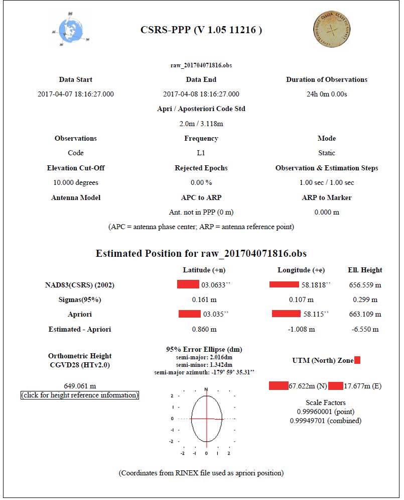
Horizontal Accuracy : 15cm-30cm. This is really good!
Vertical Accuracy: .8m - 1.5m. Arg, not great but still really good.
So what I am seeing from the Reach GPS, with it’s stock antenna, is that it is really good for determining a horizontal position, but maybe not so great for getting a good Z value.
Note: my “backyard benchmark” is not optimally placed in the extreme! I maybe have 10m clearance to numerous buildings and fences, not to mention the overhead electric wires and the nearby forest that is probably 20m away and 20m high!! So the multipath monster is lurking bigtime in my backyard!
In an open environment I would expect horz accuracy around 20cm and Z accuracy solidly under 1m, hopefully in the 60cm range. Something to test later.
Hello Peter, I would love to talk to you more about this , I assume you are in Canada, I am in the calgary area and also use the NRcan processing. I find thie results somewhat disappointing, … I have only done l1/l2 processing through NRCAN, … but I was hoping that the L1 only results would be a lot tighter then this.
Quick question – your PPP return shows it is useing only “code” … mine say “code and phase”… phase would be what you need to punch in to the higher accuratcy levels… I don’t know why this is, as I am not sure there is even a option to process one way other the other. However, is it possible the file you fed into PPP was code only? update found a document that says with L1 only you can’t do phase measurement with PPP, only with dual freq
Also to be clear, my understanding is you 95% sigma accuracy would be stated at 0.193 HZ and 0.299 Vertical. The “apriori” measurement isn’t very helpful for your final stats. Please let me know if this is not your understanding, because if I am not thinking about this right , I want to know - .
No page 5, with the satellites tracked?? that might be useful to see.
I’d be happy to follow your conversations about this too. I have tried NRCan too once but would like to know more about it. I am located in Alberta. I bought the two reach boards from you on ebay.
Hi,
Note that NRCan PPP gives more precise results after about 2 weeks when final data is updated.
"Precise GNSS orbit ephemerides
CSRS-PPP online post-processing tool will use the best available ephemerides (FINAL, RAPID or ULTRA-RAPID).
FINAL (+/- 2 cm): available in 13 days
RAPID (+/- 5 cm): available the next day
ULTRA RAPID (+/- 15 cm): available every 90 minutes (not available to download)"
This is L1-L2 precision, I believe. L1 would be less precise, I assume, but if systemic errors are not the main error factor, averaging 16 days of FINAL results would give about 1/4 the error. So, if 1 day of FINAL L1 gives +/-16cm, then averaging 16 days would give you +/-4 cm L1 only.
This assumes a lot, so I’m not sure this would be the actual results. I hope to do some tests in this area.
This would probably not be appealing to a professional surveyor because of prohibitive costs of time and travel now that L1/L2 receivers are hitting the market at less that $1000.
However, for someone without a close L1/L2 base station nearby, (say floating arctic ice or remote farm), this could give rather precise ROVER location to establish a BASE location.
Hey Brent, I think you bought those form Kevin GROVER, … I am Kevin Nemrava - Grover is a great guy though, I when to school with him. Real smart, knows his stuff.
I think we need a “Reach RS alberta working group” … lol
Oops! Sorry for mistaking you! I didn’t realize that there were that many reach users in Alberta. Wow! Two Kevins!
I’m from Stettler. Good luck and have fun!
My test were conducted in Canada. Yukon to be precise. But there seems to be a preponderance of Albertans around here!
This is my basic “take” on the ACCURACY of PPP: for L1 receivers, like the Reach, you are generally not going to do better than 15-30 cm horizontal accuracy (compared to a known point). And from my experience submitting files to PPP days or weeks after the collect doesn’t improve accuracy much (for L1). Maybe a better antenna on the Reach might help with accuracy, but my guess is that it won’t be significant. But heck, being able to determine a point, to this level of accuracy, with a $200 GPS, anywhere in the world is impressive. Realistically when I use an L1 GPS to determine a point (with at least a 4 hour collect), getting 20-30 cm horizontal accuracy and sub-meter vertical is what I am shooting for. Anything else, IMHO, is unrealistic. If you need better you will have to get an L1/L2 GPS (you don’t need glonass - an old beater L1/L2 GPS will do the trick).
So to summarize from my experience, to determine the position of an unknown point via PPP, your either play in the world of decimeter (20-30cm) accuracy with an L1 receiver or you are in the few centimeter world with L1/L2.
And you need to ask yourself why would you need cm accuracy for your base?? If you are making drone orthomosaics do you really need a product that is placed in the real world to within a few centimeters? I have been working with all types of aerial imagery for many years and I have never needed this type of accuracy.
Remember, if you have one Reach working as a base station and another as a rover, it is not difficult to maintain a few centimeters accuracy relative to the base station (after post processing). So if the horizontal accuracy of your base is 20cm (determined by PPP) and your post processed points are say 2cm (after using RTKPost), well you are working at a level of accuracy (<25 cm) that a few years ago took at least $5,000 - $10,000 to obtain.
I suppose if your are trying to do cm level survey work, with no known benchmarks, then having L1/L2 GPS is necessary, otherwise I say these little Reach units are sweet! One just has to be more aware of potential multipath situations and avoid them.
NRCAN PPP service doesn’t work only in Canada. It works all over the world.
I got similar results in Europe and Indian Ocean when I compare nrcan ppp results to ppk from known point : around 20cm difference for 4-6hours logging. It’s a good results and permit to verify known point in my case. If my know point is far than 1 meter from nrcan results, my observations are bad or known point is bad.
sorry, NOOB question here, but: What file do you upload?
*.obs? *.ubx? If it’s not something you can directly download from the Reach, how do you generate them?
Once you are satisfied with your data log time, turn off the logging and your reach rs will compress the files for storage which you can then download to your mobile device off of the pod.
If you are planning to process through NRCanada through their ppp service (just google) then ensure you are using RINEX 2.11 or 2.10 format.
Check the other forum posts for more info on data manipulation tools for post processing.