Wrong false fake fix Emlid m2
Here mask elevation was 10 - wrong fix

Here mask elevation was 30 - good fix, but with old antena elevation 10 was wrong fix. With elevation 30 old antena not work.

Wrong false fake fix Emlid m2
Here mask elevation was 10 - wrong fix
Here mask elevation was 30 - good fix, but with old antena elevation 10 was wrong fix. With elevation 30 old antena not work.
You right next to concrete structures which probably have rebar in them and the signals are bouncing all over the place.
Hi Nykodym,
There’s a lot of information wrapped in these two videos. I’ll go over the main points here.
I can see that you have bizarre results during your survey. It’s a pretty rare situation. This is not something you can catch on your daily surveying site.
What’s essential to keep in mind with GNSS equipment is that they are heavily dependant on environmental conditions, even if you’re working with a multi-band receiver. So providing them with good or at least moderate satellite visibility is a way to go with them.
As Michael noticed, your surveying conditions are rather extreme: the majority of the sky view is blocked, the concrete walls are in all directions, a lot of vegetation is going on. It’s true that the signal suffers from a significant amount of reflection and thus interference in this case. Such environment becomes a challenge for a GNSS receiver; this is a suffering common for all GNSS-related technologies and equipment.
So, there’s almost no chance of coming across the same results in a typical surveying scene. If you ever catch the same thing, please contact us at support@emlid.com with the data you collect.
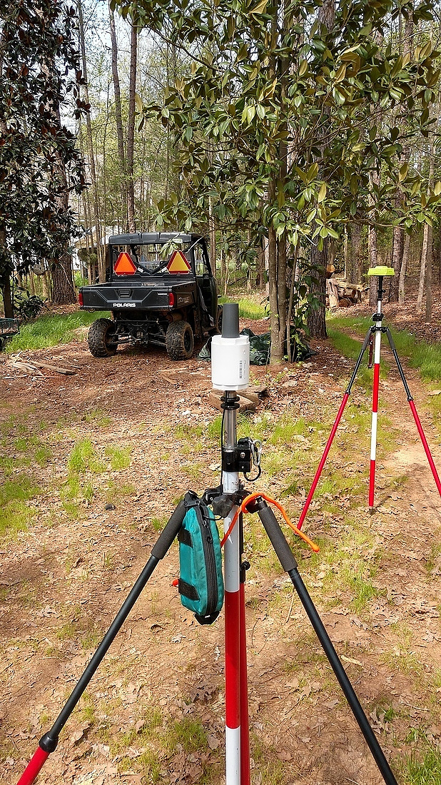
Yes. And also 3-4 meters to west is metal bridge. It have 24 meters width and near 300meters long.
i want know +/- where is border for emlid m2 when i can to recieve wrong fix???
I searh the limit of emlid m2.
Maybe it must add option “bad environmental conditions” in options to work in such places. and i will not have wrong fix. Or i will input sector of sky which i must to use.
At all i think it was good result when i make musk 30.
Hi Nykodym ! What a cool enclosure for the M2’s ! Where did you get it and what was the cost ? It appears to be a very professional looking mount.
As Polina said, environmental conditions such as yours is challenging for any GNSS receiver. I have suggested to Emlid to have the PDOP values visible on the collect screen… this would be an invaluable indicator of a bad
“fix”. High PDOP values indicate poor satellite geometry for any receiver if showing “fixed” solution. I would not trust it.
I use Emlid receivers whenever I can if I get to go out in the field with my M2’s. They are great receivers for the cost and are quality made. However I’ve learned to stay away from any high multi-path areas with the M2’s using our state RTN or doing radio RTK. Even next to wooded areas along an open field.
In challenging conditions such as wooded areas, we use our JAVAD receivers. They have many ways to verify a “fix” solution in areas like yours. They are great scientific/geodetic receivers developed by the guru of signal processing, Javad Ashjaee. The LS Triumph series of receivers and software was developed with input by many professional Land Surveyors across the USA and Russia. It’s the only receiver available today that is capable of obtaining a true verified “fixed” solution in areas like your video shows.
Try it with 5meters survey pole. And always watch the age of correction
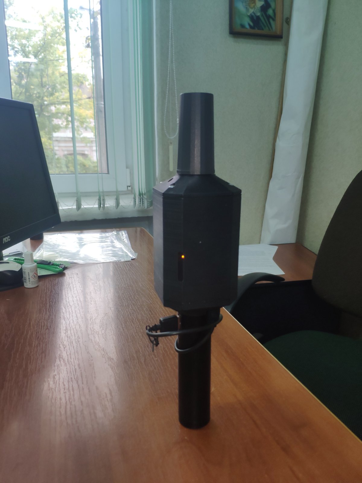
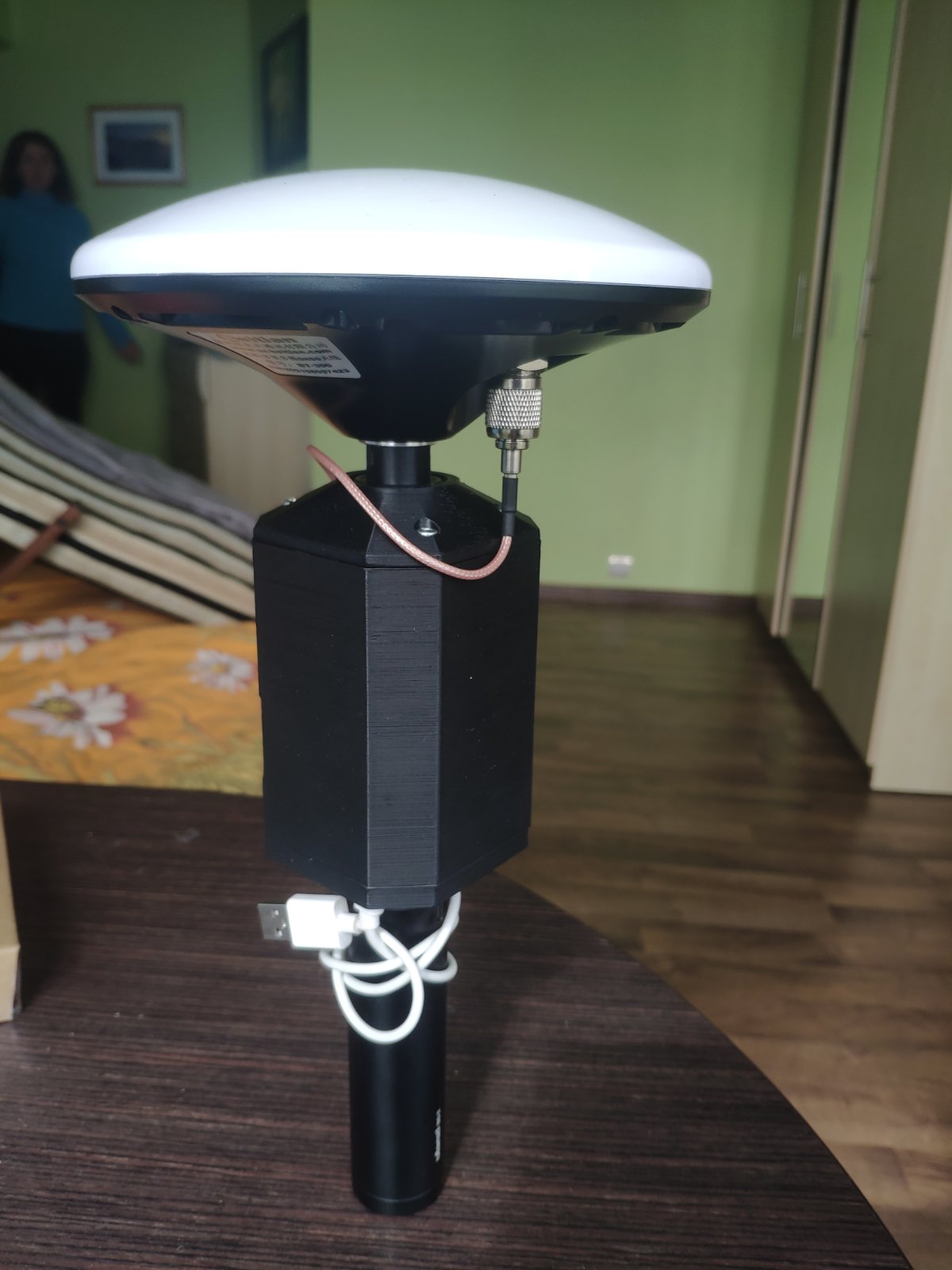
i disign it and print it myself. I think the cost near 30$. It will be in few month box like rs2 with antenna like on video. I want to make one box - round antenna, m2 module, powervank on 6800maH and button on/off.
About wooded places. If is it forest and antenna tallysman maybe. If it is garden or park or line of trees in field it work mainly fine with tallysman antenna, with round antenna work better on ~ 20%. But you must make measurement twice. 1st measurement and then you must lost fix and stake out point for control it.
It was test, i whant to know “can i get wrong fix on emlid m2”. I took it ![]()
That’s a great design Nykodym ! I designed my mount for the Emlid helical antenna using PVC pipe and just have the receiver and battery in a small hip bag hanging on the bipod. I’ve since changed antennas to the Harxon GPS 500.
I think the M2’s are great receivers. I mainly use my two M2’s for a static baseline on project sites when using my Javad receiver as a rover accessing the state RTN service. Using 3 receivers gives me a closed polygon if I loose cell coverage with the rover. I can then PP the rover with the M2’s and have a verified position for the rover points. Sometimes if I have the time, I’ll PP the rover even if it has an RTN position. Accuracy comparing RTN versus PP is usually less than 2cm horizontal and vertical. The baseline lengths are usually less than 2 km. As I’ve said many times, short baselines are your friend.
If you have 2 other receivers, you might consider trying this. It gives you absolute confidence in all of your rover points.
On the end of this history it is very impotent what antenna are you use with emlid m2. On this moment best is beidou, then tallysman, then ashtech ptomark. I whant to test also Leica AS05 antenna. I think that antenna is main part in wrong fix result.
Short yes, but 50 km also will work fine. I test baseline 97km in postprocesing. On control point it was difference ~90mm.
Good work, i don’T UNDERSTAND how you integrate 5/8" adater for pole in your box.
I print this adapter, but it is from plastic, metal wil be better.
---- my concept - one box and 2 types of antenna
i will work to make box like emlid rs2, maybe with lora radio.
Wow !!! That’s pretty sharp and very professional looking ! I don’t understand why Emlid hasn’t designed something like this. It would certainly increase sales for Emlid from a lot of surveyors.
I just used a 5/8" x 11 female/male adapter. I used a drill press to drill holes for the end caps. The helical antenna just had two small screws for mounting… I counter sank the base into the end cap about 5 mm to give additional support.
Your design is very good. When I saw your video, it looked like it was made by some manufacturer.
Thanks for your posting Nykodym !
Your idea better. I think about such box, but main problem, i don’t understand how to integrate 5/8 metall adapter into plastic box. Can you show picture how are you do this?
Also good idea to use antenna BT-560. It is cheaper in 3 times. See it on aliexpress. It have good reviews.
Hey everyone,
I’ll be chiming in here. Not much left for me to stress out, though.
What you have to check before attempting the survey is the environmental conditions. That’s the first, the most obvious but the most important trick if you want to predict the results. Knowing that the conditions will present a struggle, you might want to move from GNSS equipment on this specific area at all.
During the survey, you can monitor the DOP value to be lower than 2, the age of differential to be less than 2 seconds, RMS value to be within cm limits. Also, it’s a good practice to consider increasing the point observation time.
Still, harsh conditions are harsh conditions. There’s no going away from the fact that your environment should be reasonable for the GNSS equipment to do its work. That’s why the general working site won’t present any bizarre results.
P.S. Nykodym and Brian, both your designs for M2 look astonishing. The main thing here would be to make sure Reach has enough air for ventilation. Otherwise, there’s always a risk of watching the unit get hotter and hotter. Regarding the design from us, I feel your wish, truly. But as we designed modules for mainly the UAV use, there are no plans to introduce any other housing for now.
The mask and consideration of the quality of the satellites is also very important. This will somewhat be reflect in the DOP values but satellites can bounce around and your DOP’s may look ok at moment. It would be nice to have a sky plot of what Reach is seeing but in general the mask can take care of allot of ground obstructions.
My M2’s get warm but never “hot”. I’m thinking it could be due to the length of the power cables. Shorter cables transfer the power needed more efficiently, therefore more heat is generated. My power cables are pretty long, maybe that’s why mine never run hot.
I’m just a land surveyor not an electrical engineer.
Michael, totally! Both SNR and elevation masks can help manipulate the result a bit  I also get the request of the sky plot in the ReachView app, we’ll see what we can do here.