Wandering Fix

Power supply noise has been on my mind from the very beginning. I had thought a usb battery would eliminate ripples but then realized they have to have step up/down converters of some kind to take charge/supply voltage into account. Right now I’m thinking maybe a plain old battery might be best. But there are no 5V batteries that I know of. Efficiency doesn’t matter at all for my application so maybe a simple transistorized divider will suffice.

What are you using for a low Ripple USB power supply for your Emlids? And where did you find them?

This is on my ToDo list. Need to figure out how first.

This is actually the plan - for just that reason. I was thinking I’d mill a flat into the central post to hold the reach in place. That makes a stop easy to do - no cradle required. For the final implimentation, the pot will be painted Deere Yellow - assuming I keep it. That said, I doubt heat is an issue right now. It was sunny but only 5C when I did that test and today it is snowing out. No testing today - been out in the shop pretty much all day.

Thank you! I do like it! I wish my mill was 1/4 that nice. The mill is an old beast made in the far east before they knew about thousandths or metric. One rotation on either axis has 11 units!!! Everything must be setup and/or done by hand/eye and measured 10x. Someday I’ll either get a newer one or add a DRO. In the meantime, it gets the job done!

2 Likes

Thanks for the lead. I’ll read that tonight. But it will be a while before I can try anything. It’s snowing here for the next few days.

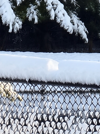
I suspect the pot mount “ground plane” may be the cause for the wandering positions. As said in previous posts here by others and Emlid, helical antennas don’t require a ground plane. It may be GNSS signals are being reflected back into the antenna from the pot mount. Also, chain link fences are excellent sources of multi-path from my experiences.

When I first bought the M2, I used it with Emlid’s helical antenna on known NGS passive marks with my pvc pipe mount (no ground plane) made specifically to mount on a survey pole/bipod mount.

Typical observations were “static only” for a minimum of 1 hour. Baseline lengths to other local NGS passive marks used for control were generally 10-20 km. Horizontal accuracies were usually <2 cm, however vertical accuracies were a bit more but usually <4 cm. Spectra Precision GNSS Solutions software was used for modeling the antenna for phase centers and post processing as it was the easiest way for the modeling of the antenna phase centers of L1/L2 frequencies. This software is no longer used as it is no longer being maintained and the “end of life” was approximately 5-6 years ago. I’ve since been using Javad Justin software for PP when needed.

I honestly think the helical antennas are good for short baselines used in land surveying and the intended use for UAV’s, but not for long baselines if any vertical accuracy is expected. I’ve since gotten 2 Harxon GPS 500 antennas for my M2’s. These antennas can be used in NGS OPUS and other online PP services and commercial PP software as they are in the calibrated antenna lists. From what I’ve seen, no helical antennas are in the NGS database. This may indicate what NGS already knows concerning vertical accuracy using helical antennas.

5 Likes

Wow, thanks Bryan. That gives me LOTS to look into.

You “seem” to emphase the vertical error. I’m not that concerned about vertical just now. That will have to wait till I build myself a tiling attachment for my tractor… Do your concerns apply to horizontal too?

Go figure on the chain link. I would have never guessed.

My baseline will not likely ever exceed 2km.

I just finished my second pot system today. This one is for the base. I had planned to try the system with both units on pots after the snow melts. But with your advice, I’ll prioritize testing without pots on both units instead.

You are the second person to voice a concern about the small Helical Tallisman antenna for ground work. If I can’t get this working with the ones I have, I’ll look into getting something else. Are you recommending the Harxons GPS 500 antennas?

That looks great! Are the M2s inside the white PVC pipe cannister under the antenna or in the backpack?

No progress planned for today on my end. We got about 6 inches of snow last night (15cm). The multipath on my evil fence is magnificent. A Robin tried desperately to land on it but just caused a Robin sized avalanche.

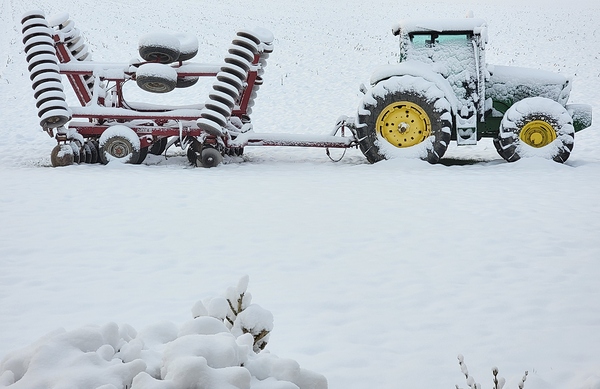
Poor tractor was all set to work, now it’s hibernating…

3 Likes

Hi there,

Thanks for the discussion!

@Susquatch, it’s hard enough to estimate the accuracy only by background map on the Status tab. Background maps are not that precise.

To obtain precise coordinates, we usually suggest collecting points using the Survey tool. Also, you record the Position log on the rover if you need continuous data.

Also, I want to confirm that this is the quote from our website. You can check it yourself here.

So, if you have some doubts regarding the accuracy, please record raw data logs on both base and rover and position log on the rover. It will help me to check if there are any issues.

4 Likes

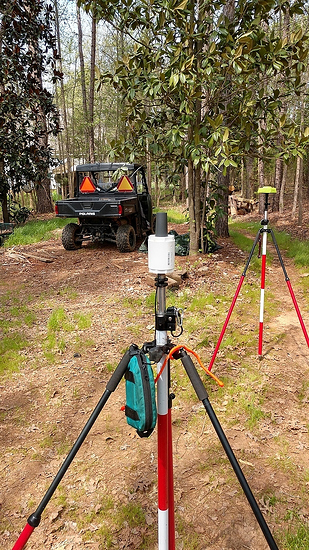
Susquatch, no the M2 and battery are in the blue bag hanging off the bipod. I’ve been planning on getting a larger dia. pvc pipe where I can enclose everything. There’s been some concerns about the M2 over heating, but mine never has even after logging data 4-6 hours. It’s got warm though.

The Harxon GPS 500 antenna is a good antenna and was reasonably priced at the time I bought two of them. They were about $250 each I think. It’s like anything else, you get what you paid for it. During post processing, I’ve noticed a “cleaner” data than the helical.

1 Like

Silly question - can I mix and match antennas or do they both need to be the same?

Also, the 500 appears to be discontinued. I noticed that the Harxon 600 requires power. But I don’t see a separate power connection. Where do they get power from? Does it come from the M2 over the antenna wire? (sort of like POE)?

You mention that you use a battery. May I ask what battery you use?

I mix different antennas and receivers when I’m doing static observations. It can get cumbersome if you use more than 4 different types. If you’re using RTK, it’s a matter of just inputting the different antennas. However, I don’t think Reachview 3 allow different antennas. It’s assuming you have the RS2.

As far as the Harxon 600, others here have used it. Make sure the current draw meets the M2 specs.

The antennas get the power from the M2 via the antenna cable via the power source (simple 2A usb power pack, 10000 mAh)

Hi @Susquatch,

I also want to add that I’d not recommend using a pot as a ground plane for your antenna. We usually recommend using a piece of metal as a ground plane since we can confirm the metal reduces the multipath effect. However, I can hardly predict how pot material deals with the multipath.

So, I’d suggest at least testing Reach M2 without the pot.

2 Likes

Thanks Bryan. That’s more or less what I have been using for a battery for my Rover too. I’ve been using a charger adapter for the base and I thought perhaps it might be too noisy. So I tried a battery there too and it made no difference.

No testing today either. Maybe tomorrow.

1 Like

Others have raised concerns about the pot too, so testing without the pot is a priority for me.

However, it’s important to know that the pot is Coated high grade aluminium about 4mm thick. The base is perfectly flat and polished with no coating on it and it is only slightly larger than the size of the ground plane recommended by Emlid. In fact, it was Emlid’s antenna recommendations that caused me to buy it. The pot was the cheapest way I could find to buy a nice thick flat piece of solid aluminium that met your size recommendations. Originally, I was going to cut the sides of the pot off, and just keep the flat part, but then I realized the sides of the pot made a perfect weather enclosure and the open bottom would ensure that it would never get too hot. Therefore, I have kept the sides for now. If testing shows that the sides are bad, they will be replaced with an upside down plastic margarine container because I really do like the weather and temperature protection that I believe an upside down container provides. If subsequent testing shows that the ground plane is bad, then that part of the pot will go too. I’m not married to anything except getting the best performance that I can. But I am a bit stubborn about not letting unconventional ideas get tossed without giving them a good try.

I confess that I do regret my antenna purchase though. The Helical unit was the one packaged with the Emlid. I just didn’t know enough at the time to realize that it was specifically intended for drone applications. I assumed that it had to provide decent performance or you wouldn’t sell it.

I can’t test everything just yet. We got a dumping of fresh snow yesterday. I have to wait a bit before I can get outside again. But I’ll keep you posted about my findings and progress.

1 Like

Tallysman Antenna

@Susquatch You seem to be the first guy who has had issues with this milspec antenna.

If you look at my screenshot with the poor fix off a distant off brand base, it works quite well under very poor conditions.

Also i think you will like that its the only one that sheds dust in AG applications, you never need to stop for a wipe.

The factory that makes it is in Ottawa Ontario, right close to where you are at.

1 Like

Hi @Susquatch,

I understand your point regarding weather and temperature protection. However, it’s indeed hard to predict how it affects accuracy without additional tests. So, yes, please keep me posted. I’m interested in figuring out your case.

Reach M2 antenna should work well independent of its application. It was designed for surveying in general, not for drone mapping in particular. I’d say that there is no big difference between these spheres in terms of required antenna specifications.

Also, we’ve tested our antenna in different conditions, and it works the same way. So, the issues you experienced aren’t related to the antenna. We’ll try to sort them out.

Great day today. I cheated a bit on my plans. My bride had to help out with our grandkids so I have the day to play with my gps system.

I had originally planned to test without pots out in the open today as my first priority. But convenience got in my way. As I mentioned previously, I finally finished the pot enclosure for my base, and I had to establish a new base location anyway, so I set my base up in the regular location WITH THE POT to do that. Then I set the rover up in the planned new location again WITH THE POT to get a location that could be plugged into the base.

The first thing I noticed is an immediate solid fix. So I set the status map to collect 10,000 points and let it go.

Amazing… Everything seems to be working just fine! The fix stays in the middle of the cluster the vast majority of the time and only wanders a little from time to time. So I feel pretty good about the accuracy for my planned field work.

Both Static and kinetic work almost the same. Maybe as Potatoe Farmer said a wee bit better in static mode.

Maybe the pot works after all by reducing multipath at the base! (reflections from the house, the fence, the pergola, the bushes), Or maybe it’s just the rover that is working better in the new ideal position with less multipath. Or maybe it’s a combination of both.

After lunch, I plan to move the rover back up to the house to see if it was the rover, or the pot, or perhaps both. Nothing will be proved absolutely, but it doesn’t matter. It’s working in the configuration I originally hoped to achieve, so I am MUCH happier.

After the simple tests this afternoon, I have to work on optimizing my standard setup. What constellations, what update frequency, etc etc

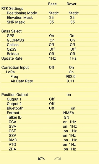
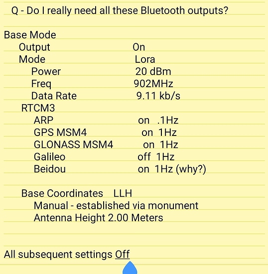
Here are my current settings, provided both to solicit comments and suggestions, but also just to document what worked so I don’t forget.

Edit : no idea why the submitted format is so messed up on the forum. I’ll take screen shots and edit again shortly.

Comments and recommendations appreciated

4 Likes

I moved the Rover back up near the house. No difference, works fine.

So based on this one pair of tests and very limited experience, I would say everybody was right. The problem was too much multipath around my base (house, fence, bushes, pergola, etc). And, it seems the issue was significantly reduced by adding a ground plane to the base. (I’ll refrain from calling it a pot…).

I plan to try a few field runs shortly. If they work out, the next step is brackets and power supplies for my two tractors.

I did a quick field check. Seems to be working very well now. Using “Field Navigator” on my Tab4 Tablet, it was pretty easy to setup a field and do a little pretend narrow spraying on my atv.

They say we should be careful what we wish for. Boy does that ever apply. It may take me a lifetime to drive to those new guideance lines. SENSATIVE!

A marker disk line might be easier.

Spraying and spreading should be a piece of cake though.

Question: My main tractor for spreading and spraying has no cab. My Tab A is really hard to see in the sun. My S21 phone is easier, but isn’t very big. What do you use for a display? Does a hood help?

1 Like

Ok some setting suggestions

Base set to static, Tractor rover should be to kinematic. Kinematic will help on the tractor because the filter will assume you are moving on a path increasing the accuracy of the path.

Mask; I would set the mask to 12 degrees, if your under trees it will still be able to squeak out a position, this will be the same on base and rover. The emlid will only use the best satellites for the solution anyway, the rest it just tracks until they become the best to use. Its only using 3 to 6 to compute a position.

If you are taking the base with you and distance is not an issue "Within the section, 640acres " to the tractor try a higher data rate. Somewhere around 19200baud, the emlid lora values are a little lower than the normal 232 baud values. I always leave radio power cranked no RF emission rules apply at 0.1w in my area , frequency is whatever works best for you.

The faster you can pump the correction in the faster it can be used to compute a solution.

You only need to send the corrections that the rover is using for a solution. In your current state Beidou would not be needed.

But I suggest using all constellations, except QZSS in north America. Reason being if you loose fix at the tractor the computed position off the Emlid is better than WAAS accuracy.

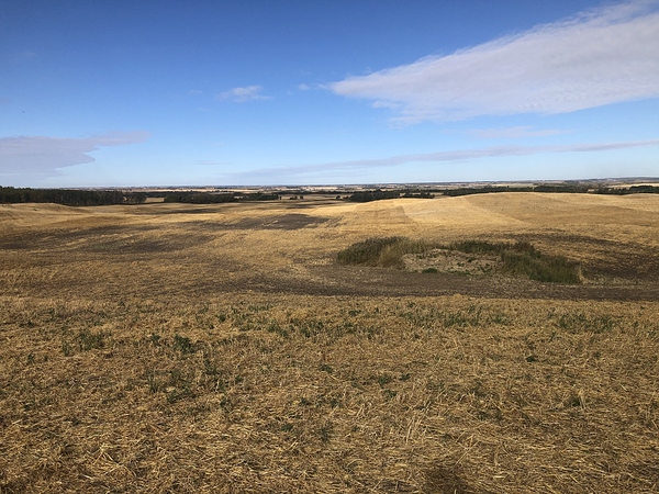
Here is a field harrowed using an m2 all constellations active and no rtk corrections, still very straight.

I am not sure what Hz your light bar program requires, but you wont be able to react faster than 1hz steering by hand anyway. With automated guidance the fastest it can handle 5 or 10hz is beneficial, it allows the errors between readings to be smaller and requiring smaller steering movements.

All subsequent settings off, perfect no use chewing up processor power on stuff that you are not using at all. This will also lower power requirements, and module heat creation.

For your base coordinates, if you do have a good spot to put the base year after year, survey in for the maximum time. Once the reach has coordinates, find the drop down that locks those to manual. Write down the coordinates for future use. As long as the same coordinates are used for that exact spot are used, your passes will be the repeatable year after year.

Your passes will be completely accurate relative to themselves and repeatable, though the position may no be absolutely precise to the survey. Absolute Positional accuracy is not required for farming, and requires PPP, or other survey methods to accomplish.

3 Likes

Wow! What a fantastic comprehensive response. When I saw your harrowed field I got homesick. I miss the prairies…

Got it and understand why.

Hmmmm, I had trouble with a low mask at the base. There is a forest to the west and a house to the south. I set the mask based on an angle measurement to clear them. I’ll try a few other settings over the weekend. Does the rover really have to be the same as the base? Can it be a lower angle? And if so, what happens if the rover finds a good satellite at a low angle but doesn’t get a correction for that Satelite from the base?

I don’t plan to move the base at all other than back and forth from the house to its location at the top of my lamp post. But the wife wants a clothes line, so I may move it to the top of a clothes line post if that works out. However, I tried higher data rates and the fix loses reliability for some reason. But I’ll try it again now that the ground plane is installed.

OK, I’ll kill corrections for Beidou. Frankly, I’m not sure why I had it set to send corrections for anything but GPS & GLONASS.

Ya, I had the same issue with this as for the baud rate. For some reason the volume of data seems to choke my system. That’s why I disabled everything but GPS & GLONASS. I’ll try it again with the ground plane.

So beautiful…

I hear you… I did have problems with the program at faster update speeds anyway. It started throwing triangles instead of a path. I might even slow that down some more. I am old and slow… I won’t really know what I can follow until I actually try. It was all way faster than me today.

Actually, I have a nearby monument and I used that to establish a good fix for the base. See my other thread on establishing base coordinates. Establishing a base coordinate without a reference

Bottom line is that I created a corrected manual input by comparing my rover to the monument actual. So my fields should all be good both year-to-year and true to actual accurate Lat/Lon and I should be able to survey with it too.

In summary, I’ll play with your suggestions to get as close to them as I can and let you know how it goes. With the ground plane in place, it may turn out to be easier than I fear.

Thanks again!

I sure do love your farm…

2 Likes

The mask is anything below that angle gets ignored. But now the fancy math comes in since one is mounted to a tractor that does not stay perfectly level. If your mask is set 25 degrees, and now your tractor nose is pointed 25 degrees in the air driving uphill , you have effectively made a 50 degree mask in front of yourself that drops a lot of satellites in view. The antenna sees all ways, but not out the bottom.

If the mask on the base is high and ignores satellites that your tractor needs corrections for you end up loosing fix. Best to have them set lower and the same.

Well why not set them at 0? you might ask, the lower toward the horizon the more messed up and dirty the satellite signals ( em radiation) are due to having to travel through more of our atmosphere. The same way light (em radiation) gets messed up making the sun look huge at sunset.

Lora and baud rate, the lower the baud rate the further it will go unobstructed.
The higher the baud rate, the more data can flow faster.
Using slow baud rates means you will have to use less constellations that reduces data.
If we are only using one constellation, the lowest amount of data, it is still advantageous to use the highest baud rate. If a re transmit is required it takes up a fraction of the cycle, also less chance of running up against the output buffer.

But Lora is line of sight, it pretty much only works well if you can visibly see the other antenna.

3 Likes