Has anyone tried using REACH under tree canopy? I am trying to survey sub-tropical rain forest for a house site, about 30m x 30m, in New Zealand. There is an govt GNSS (all bands) ground station 25km away.
My plan is to post process the fixes with the govt ground station or set up a nearby reach unit with a clear sky view. I have thought I might need the Tallysman 40dbi antenna to increase the SNR. The fixes need to be <50cm (but <20cm would be better) relative to each other. The height I will get optically from either a dumpy level or rotating laser.
Has any one had experience using reach under a canopy? Does it get a fix? and approx how accurate is it after post processing?
Will the more powerful antenna make a difference?
Which base station would be best to use, a close reach station or the Govt GNSS station?
I’ve tried Reach under the tree canopy, and it has produced a fix, but there are some things to consider:
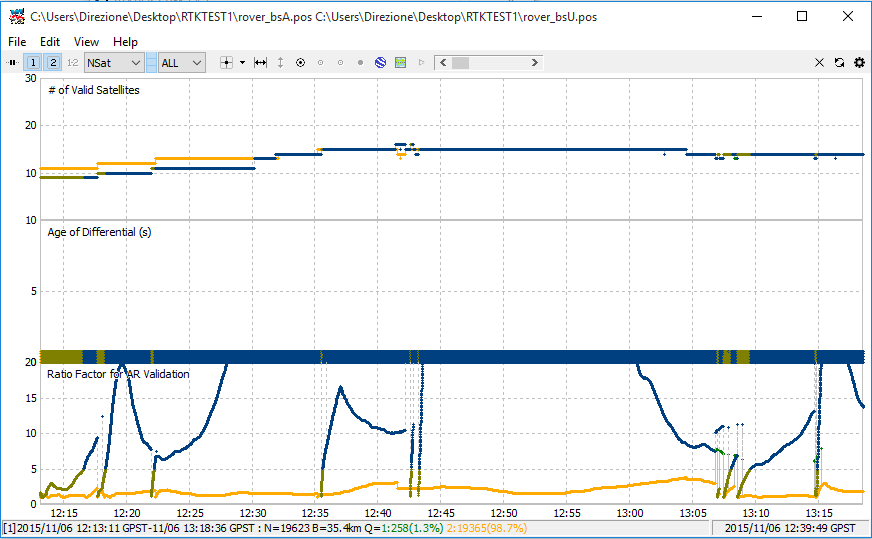
There will be no fix if there are not enough satellites in view. (Logging for a long period of time can help while you wait for the satellite geometry to change or for the wind to push some leaves and branches out of the way for a few seconds.)
If the antenna receives multipath signals, then RTKLIB could be fooled into producing a fix from those reflected signals. (Adjusting RTKLIB settings could help, or some culling of the data either by visual cues in RTKPLOT or by doing further processing of the files)
Sometimes it is just not practical, but there is no substitute for elevating your antenna to the altitude necessary for a good sky view.
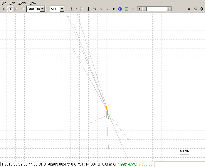
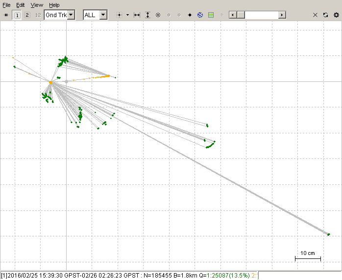
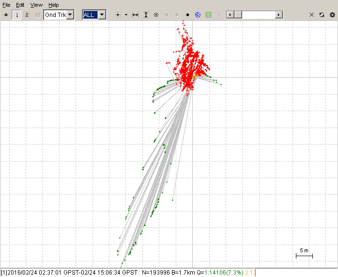
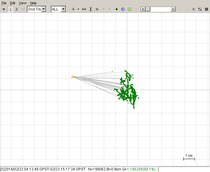
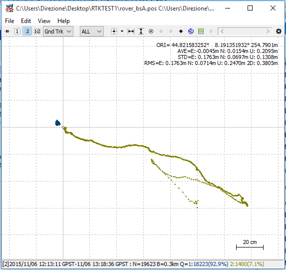
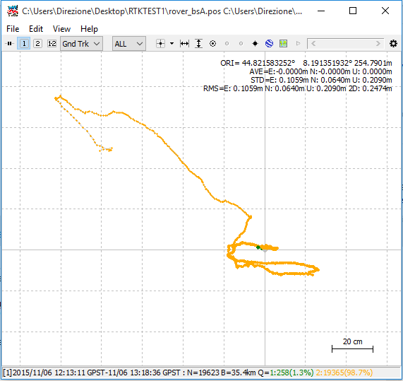
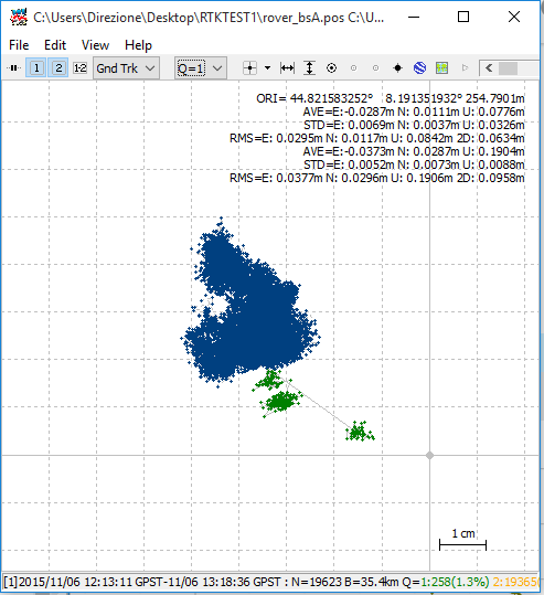
Here are some examples of the outcome when working with a blocked sky view in the trees:
The fixes are the surrounding green dots and with the yellow floats in the middle. In this picture, I wouldn’t consider any of the green fixes to be correct.
This one looks quite bad as well, but with RTKPLOT, you can zoom in and see if there is a small spot with 90% of your fixes. If you see that, then you can safely discard the outlying ones that are clearly errors. The red is single mode (no RTK), but there are yellow floats and green fixes hiding in there too.
We can’t leave this off on a bad note, so here is one of the good fixes. I hope to be getting more like this. If everything is good, then it works really well and there are no fixes out of place. This one is done with the antenna raised up 9 meters to the height of the canopy. Consider that it is mounted on a flexible plastic pole held in place by strings, so the wind does move it around a little bit:
It sure would be nice to get a good fix right on your marker with a little raising/cutting and not have to traverse from a place with a better sky view. I’ve been dealing with traversing in, and after doing it a few times, I’m still not happy with my accuracy. So far the best I have done is with the Brunton pocket transit and a steel tape. I also thought about marking a few accurate spots nearby to sight in from and averaging those results. That should also give an idea of the margin of error.
For the occupation time for each screenshot above, just look at the bottom line. It has the start date/time(GPST) and the finish date/time(GPST) as well as the number of position solutions (N), the baseline length (B), the number of fixes (Q=1:) and the number of floats and single positions would be there if I made the screenshots bigger.
By all means copy the antenna mount. Good luck with it and maybe you can improve on the idea somehow.
I was also looking at those higher gain antennas with the threaded mount and the low-pass filter. I can’t remember the model I was looking at, but every website said, “Click here to request a quote.” and I thought to myself, “If I have to ask, then I can’t afford it.”
I was going to give it a try. When I get the two reach units should be easy to compare.
Nice old school on the compass! I was going to try a dumpy level sighted and set up on a known bearing with an LRF for distance. Kind of a poor mans total station…
I’ve used this Digikey 1526-1010-ND Tallysman antenna and I was able to get a fix much faster than with Reach kit antenna.
You must be sure to use a three times larger ground plane than the diameter of the antenna.
If you have access to a 3D printer making a holder for this antenna should be easy. Combining the ground plane into the antenna container might make using the antenna more convenient.
Regarding ground, would any metall plate do? Have read that copper or brass is the best.
I have zink, galvanised steel and flexible led to work with here. Any thoughts around this?
and you need a very good view of the sky. The canopy and the branches are going to give you trouble with multipath. If you want a precision under 1 meter you definitely need to put the antenna above the canopy.
I use aluminum foil tape and I find it works very well. The foil tape is very light weight which is good if you want great GNSS antenna reception on your UAV.
Any conductor works. The better conductor the better the shield I guess. Gold would be the best and I imagine thats why it is used a lot in satellites.
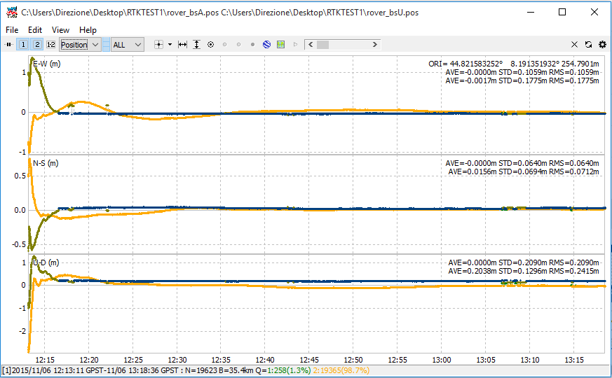
Hey thanks, when I eventually get the survey done, I will try both. I did some post processing test from two GNSS sites 100km away using the L1 signals only and the results where still pretty good using the RTKlib, within 5cm from the actual position.
Thanks, just did the same between two base stations, same result - floats are ok accuracy but the fixes (if you get them) are where the money is. Trouble is they are rare and the exposure time for the fix a way too long
If you want accuracy and precision you could determine the base station position processing with the Govt GNSS station (better if you get a fix) and then use your local base station with the position acquired. I often do that when i don’t have cellular network to connect to the govnment NTRIP caster (witch uses VRS anyway).
New to Reach.
Purchased to set property boundaries on a 150 acre plot of land.
Been checking the accuracy of Reach.
Discovered accuracy to be off by up to several meters when trees (defoliated, wintertime) are within even 10 meters of position.
Accuracy when out in the open seems to be within the centimeter accuracy stated.
There is a US Government NGS marker just off the property, so soon will set up over the marker to determine true accuracy.
In my opinion, attempting to achieve centimeter accuracy under tree canopy may prove troublesome.
I have progressed and learnt a lot about the limitations of Reach in 12 months. You are right under a canopy it is impossible to get that accuracy. I cleared/used some windows in the canopy and had a 4 m antenna pole with long exposure and got 1-2cm. Got at least two points for a bearing and used optical instrument (builders level) and LRF for the rest of the points under the canopy. It worked very well.