


Thank you for the detailed help! It’s nice having all you professionals around to learn from! (you all know who you are!) ; )
Thank you… but I think this may very well confuse some at first and increase chance for error if not understood correctly. At the start, EMLID based everything off of LLH (ellipsoidal height)… SIMPLE… but obviously, users wanted more. Coordinate Systems to choose from.
EMLID has such great help and videos… very well made, simple and concise. Maybe a video could be made when EMLID gets around to it? I know things are always changing and these things take time. Probably already in the works! ; )
2 Likes
Thanks for the feedback! I agree that the current workflow indeed requires a deep understanding of how things work in ReachView. We’re thinking about how to make it clearer.
4 Likes
I personally am still learning, and I think most are. but from what I see and comparing it to onsite survey points and others. It seem what I am doing is pretty spot on. Can I say 100%? NO and never have made that claim.
What do you mean by Manually putting in Coords. Yes I know how to… But if receiving corrections from NTRIP and putting in using a 2 meter pole for rover in RV3. Are you saying you still need a known point on site?
1 Like
That’s what we needed to know! That’s a big deal for us when we get out into the field and we don’t have connectivity.
2 Likes
Are you saying you need a KNOWN POINT? I don’t understand? Manual input means you need a know coords… and what if your using NTRIP as base?
Sorry I don’t get it.
1 Like
Are maybe that’s what he is saying, If you have no internet…?
1 Like
That would be the only reason to run a local base.
1 Like
Curious.
When NAVD88 is designated for the vertical height to arrive at orthometric height, shouldn’t a GEOID also be stated? We have different geoids. I.e. GEOID12B, GEOID18. (yes, I know, 2022 or later this will all be changed!)
I guess what I mean, seems just stating NAVD88 on a design, survey topo drawing, or as above EPSG example isn’t quite enough is it? Too general?
Seems the specific geoid used should be stated also?
1 Like
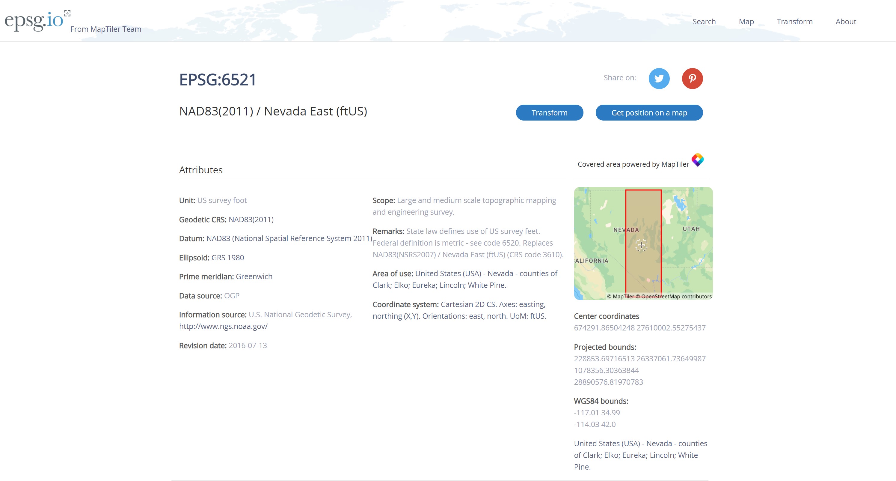
Agree, Ill send a screenshot of my options under epsg 6521
1 Like
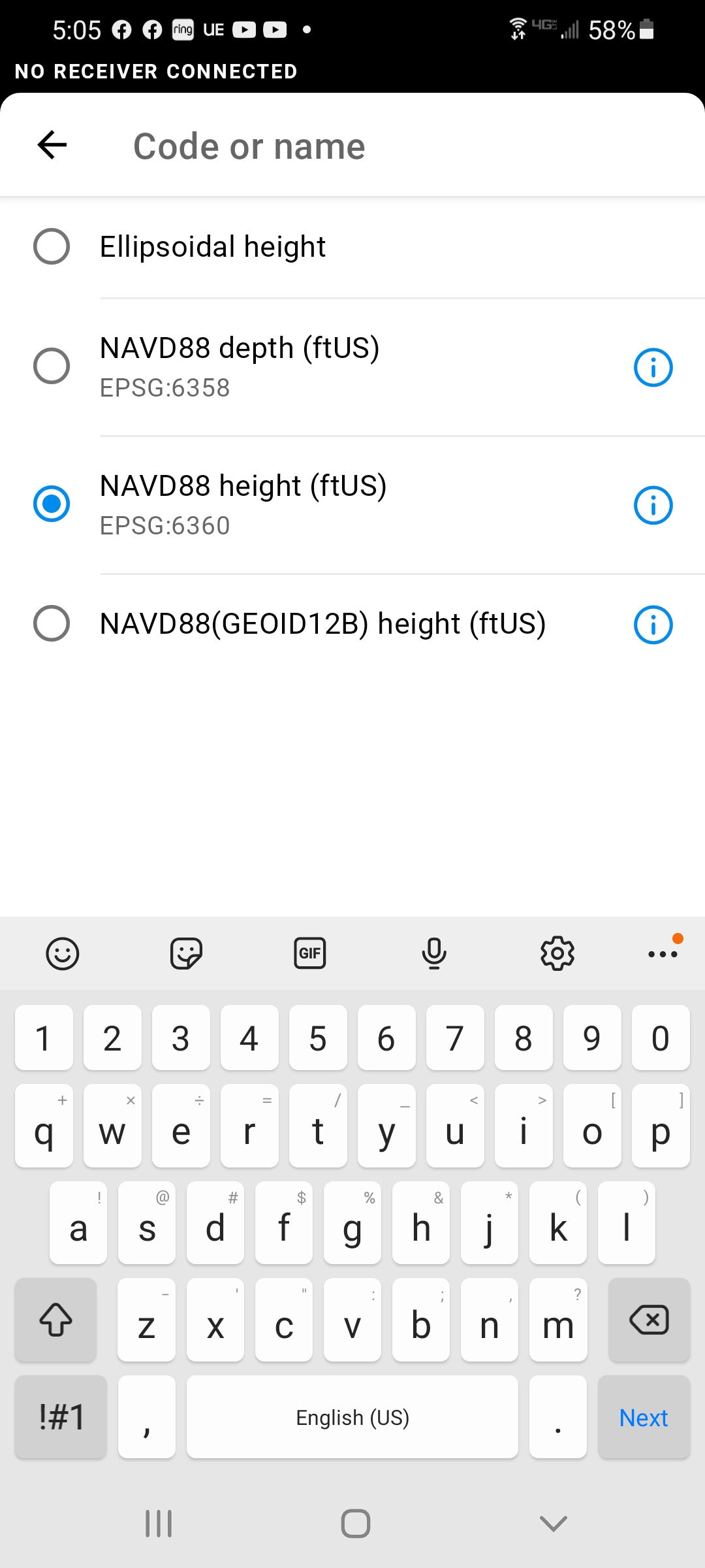
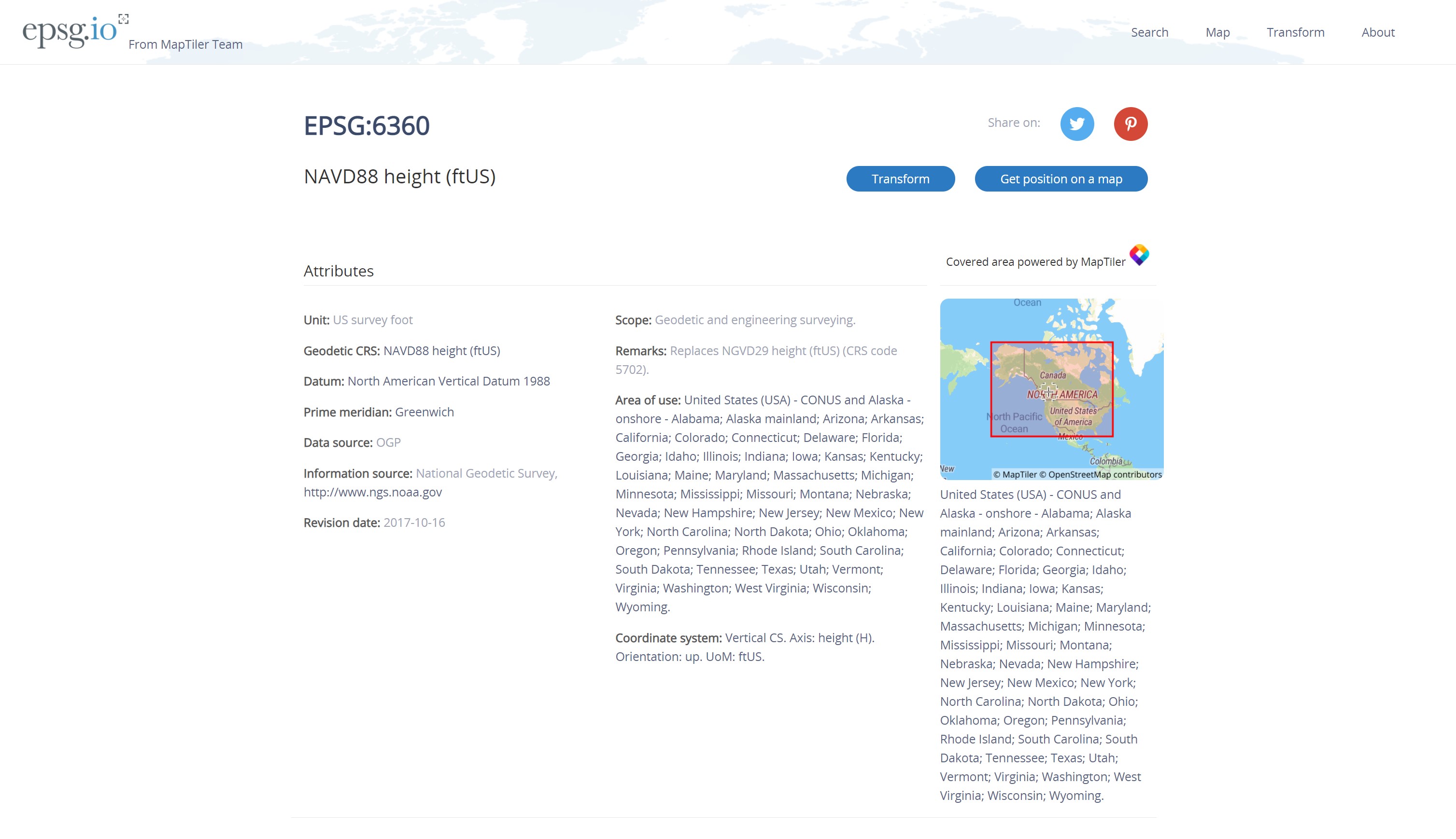
The right ! , tool tells you nothing about Geoid 18 or not
1 Like
I assume it is because 12B is not selected
1 Like
I recently learned from an Emlid tech that 6360 is based on GEOID18 despite it not saying so like 12B.
4 Likes
Sorry @mcwllc702.
Those weren’t directed at you to specify a specific geoid. ; )
I guess I was trying to word it as it seems I see a lot of NAVD88 just stated for height, but no specific geoid along with it. I.e. design and topo survey drawings. Almost like NAVD88 is the datum, and a geoid used is a sub-datum to complete it?
…and therein lies a problem and is part of the reason that level-looped vertical BM’s do not match the values that you would get on NTRIP. NAVD88 is a vertical datum and GEOID is a model. NAVD88 could be likened to the GCP’s of the model. I say the model but I am going to leave all the different kinds of models alone. GEOID18 is the current standard (CONUS) produced as a result of verification, correction and addition to the the original data of NAVD88. The number of stations used related to NAVD88 to create GEOID18 was about 32,000 which was about 7,000 more than the number of stations that were used to create GEOID12B.
5 Likes
No, it was not, because it was not and I have to try and figure it out on my own is… A general contractor will hire me to map a job site, just for general Project Management and general measuring. Nothing like property lines of a guarantee of any point. Just to have a nice map and model of site conditions and can do really good inspections in the software.
BUT, the surveyor will not give me any info, even when I ask the GC to ask him or talk to the civil
engineering firm, etc… For example- can we get what epsg codes you are using for this site? ( what is that)
2 Likes
Being a contractor I can say you need to localize to the construction site elevations meaning that you need to get a known vertical benchmark on the site so that you can adjust your data. If your best guess was 6521 for the EPSG then that is probably the correct one as almost all CAD in the States comes in NAD83(2011) ftUS but what you have to be careful of if there is an event where the CAD is on a local grid in which you would need a horizontal localization in addition to adjusting your elevation values. Without this the data is useless unless the contractor knows how to realign everything in CAD.
1 Like
Can you localize using the RV3 app? or is another software needed?
I have set up on know points in the past to see if I was getting the same numbers x,y, and z. But have not had experience in Localizing my unit… Thanks
1 Like