


This is my first time entering a manual base coordinate. I usually do average single for the base location but want absolute accuracy now. My rover unit keeps switching back and forth from single to float, the corrections input coming from LoRa switches back and forth from receiving corrections and waiting for corrections. The baseline is reading as in the 200s of meters even though my rover is roughly 5 meters away.
Maybe send the system reports to support@emlid.com or upload here if you want, but be aware may be sensitive info in the files. I.e. your location. (But already provided).
That way the settings can be looked at to find what is wrong.
1 Like
My height was incorrect. I set up the unit to do average single, once the location was accumulated I copied that height and used it for my manual height along with my known Lat/Long. Is the height ellipsoid height? I’m unfamiliar with this term and not sure how to calculate it for future known points.
2 Likes
Yep, you need to input elipsoid height when using a manual base coordinate
3 Likes
If I’m given an elevation, how do I calculate ellipsoid height? I’m not very familiar with geoid, orthometric, or ellipsoid height. This seems very complicated to me.
1 Like
You can start here for manual conversions:
“NGS Coordinate Conversion and Transformation Tool (NCAT)” NGS Coordinate Conversion and Transformation Tool (NCAT)
There is a lot to learn. It’s a journey. It’s not too complicated, but you need to make sure not to mix things up. I.e. feet to meters, Northings and Eastings, etc etc.
I am not really using ReachView 3, (I use FieldGenius for all that), but you should be able to use RV3 with your horizontal coordinate system needed (NAD83) and your vertical datum (NAVD88) and GEOID. (GEOID18). In AZ.
3 Likes
If I’m not concerned with elevation for the data Im collecting, I only need it for my manual base coordinates, can I use an estimate? Or does it have to be exact? Can I set up my base in average single, and use the ellipsoid height it provides with my known lat/long?
From my experience, if the base coordinates aren’t at least close to what the actual base position is,
YOU WILL NOT GET A FIX ON YOUR ROVER
4 Likes
Yes that is correct . The info you get from average single or fix or by post processing needs to be used when manually inputting base info…the next time you start or come back to that location.
Exactly what I’ve talked about in previous posts. If you select a coordinate system, i.e. state plane zone, the base cords should be in linear units for that zone and in orthometric heights. The software should automatically select the appropriate geoid or be manually selected !!
2 Likes
Hi @evar,
Base coordinates indeed can affect the rover’s solution. You need to set them in geographic coordinates and ellipsoidal height format to get a fix.
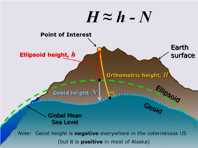
As shown in the picture shared above, we have three surfaces: ellipsoid, geoid, and topography (our real terrain). Both the geoid and the ellipsoid are models of the Earth. However, the geoid surface is more complicated. Using the geoid allows working with heights related to the sea level. So there are three height values:
- Ellipsoidal is from ellipsoid to topography;
- Orthometric is from the geoid to topography;
- Geoid-ellipsoid separation is from geoid to ellipsoid.
You can read more about placing the base in this article from our docs.
When you use Average Single mode, you receive WGS84 geographic coordinates and ellipsoidal height. If you already have coordinates you want to use, it’s important to know their coordinate system.
2 Likes
I have the same challenges while working on staking out points in our local coordinate system (UTM ZONE 31N Minna).
There should be a way around this, instead of having to work in WGS 84 all the time.
Can anyone help with this please?
Thank you
1 Like
Hi @olubolace,
ReachView 3 supports different coordinate systems, in particular, UTM zone 31N Minna. To work with this coordinate system on your rover, you need to set base coordinates in the Minna coordinate system.
To stake out points in UTM zone 31N Minna, you need to create a new project in ReachView 3 and set such a coordinate system for it. This video guide from our YouTube channel can help you with it.
Thank you Julia for your prompt response!!
However, I have always had my setup in conformity with the attached video except for the height input.
I will try to find our height system and add it to the project to see if the points would remain fixed and the distances between the base and rover are correct.
I will update you with my findings.
Thanks again
Hi @olubolace,
It’s important to set the proper altitude for the base station, even if you work with plane coordinates only.
Please note that the base height should be ellipsoidal. To work with UTM ZONE 31N Minna coordinate system, this height should be related to the Minna datum.
1 Like
Obviously the KNOWN height should be accurate as possible, but curious, what is the max vertical height tolerance of error before excess incorrect calculations are made or simply rejected?
1 Like
Hi @timd1971,
From my experience, I can only say that the rover will be in Single if the base’s height is zero. I don’t think the relationship between errors in the base’s height and rover’s coordinates is linear.
I established a benchmark using OPUS. I then used the OPUS Lat. Long. and Elev. for my Base’s manual position. The Rover is set to FIX for collecting points. The Rover says it is receiving corrections but the red “Single” does not change to Float or Fix when Measure is tapped. The baseline is less than 200 ft. Communication is LoRA.
What should I look for to correct this issue?
Did you use ellipsoid height or some local geoid?
I have looked at the coordinates and the longitude is “E”. I have put a “-” sign in front of the longitude (-111.xxxxxx) but it still is -111.xxxxxxx E. How do I get a West longitude?
Elevation is from NAVD88 (Geoid 18). I have the receivers using NAVD88. So I hope the elevation will work.