Hi everyone,
I have a couple questions below and would appreciate if you can give me some insights.
Is it correct that a Reach RS2 can function as either a base or a rover?
Are there any fees to switch one from base mode to rover mode and vice versa?
Can these Reach RS2 units communicate with a different-brand base (or rover, eg. Topcon, Trimble, …) or just with Emlid ones, in an RTK application?
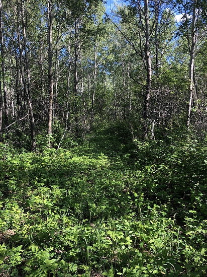
How well are these Reach RS2 units in a forested environment (i.e. surrounded by trees)?
Are the software free to use or paid?
Is it true that I will also need an iPad to control these units in the field?
Does the Reach RS2 Survey Kit (at this link) include everything necessary and ready to use? Particularly, do I need to buy extra cables, batteries, …? What are in the box?
And do you know if the posted price $4,398 for the RS2 Survey Kit is final or there needs to have tax and shipping costs added?
1.Yes, and you can do the same with M2 as well
2.NO, just a checkbox and settings menu
3.Yes, I use a Trimble base. RTCM3.X output is needed.
4.
No problems fixing in this, provided I had cell coverage. Cellular was the weakest link to my trimble base 38km away, not the view of the sky. You can use the data off your mobile device or insert a sim card directly into the rs2 for cellular connections.
5. Software is embedded in the unit, as well as a free survey app for mobile devices.
6. I use my iphone, you will need a ios or android device as a data collector.
7. You need to provide the poles and tripods. Accessories depend on how you want to get corrections, or how and what data you want to use on the RS2. You only have the battery inside the unit, it charges off a usb c connector.
8.Tax and shipping is always extra and dependant on where you live.
I use RS2/M2 primarily in agriculture, for fence lines, tree lines, elevations, and machine control.
Any base that outputs RCM3.X can be used with the RS2. If not using NTRIP and receiving corrections via data then the issue is matching radios.
As far as using as a base for other brand rovers, maybe depends if they can receive RTCM 3.X and how you are transmitting corrections, internet or radio.
@PotatoFarmer@jp-drain-sol. Thanks for your information. Do you have any experience with Topcon HiPer HR? For a rover to quickly define location of a base and GCPs for a drone project, what are pros and cons of RS2 and Topcon HiPer HR? Apparently the Topcon is much more expensive but beside that, what about other specs? Thanks.
Be careful in multi-path areas with any GNSS receiver. Unless you have some method of verifying the point, you’re taking a big chance in relying on the RTK solution.
@jp-drain-sol. Thanks. It’s good to know Trimble works well with RS2. By the way, may I ask which Trimbles do you use? Which one do you suggest for quickly obtaining coordinates of a base and GCPs? Or any Trimble similar to Topcon HiPer HR?
All of my Trimble equipment is Ag related. FMX or TMX monitors, AgGPS 542 base station.
I have never done any of the GCP’s, PPP etc. No need in what I do. I am not surveying for real world accuracy. All of my work is dependent upon the base location, in particular elevation as we are either creating waterway ditches or installing sub-surface drainage tile.
We’ve got all Javad gear here. Their equipment is light years ahead of all the other manufacturers. Their receivers can go places where the sun doesn’t shine. They have an excellent software methodology and superior equipment that will guarantee a true fixed solution. In fact, at the beginning of their Triumph LS receiver launch in 2014, Javad himself guaranteed that their receiver would never give a bad fix if the user followed their method of point collection. Many of the trial beta testers (including ourselves) and first buyers of the LS tried their damnest to get a bad fix. Emlid has no verification of their fixed solution from my use of their equipment. Emlid would learn a lot just by reading the LS manual.
With that said, if you don’t have Javad equipment, either verify with terrestrial traverse (closed loop) or have another two bases onsite nearby to PP with a closed loop. If that’s not possible, you can PP with adjoining CORS that are nearby with short baselines and long observation times and closed loops. Keep in mind that long observation times are necessary to get an accurate solution in high multi-path areas. From my experience, short baselines and closed loops are your friends.
Luckily most of my activities have error checking built in. If i really was in a position where the point had to be perfect like finding property corners, that’s what professionals are for.
But at least I do not have the awkward situation of clearing the neighbours trees due to poor sight lines for fence. +/- a foot probably would work for most of it, cm just makes it so much better.
Some of the surveyors around here don’t really mark the property lines as they should. From what I’ve seen and talking with clients that are dissatisfied with their work (not marking-flagging lines), that’s an additional cost. And that’s fine, but make it aware to the clients. Some clients are just investors and aren’t really concerned about the flagging of the lines as they will flip the property in a short time.
To stay competitive though, I give our clients the option of marking or no marking. There’s a substantial difference in costs as marking/flagging of property lines is time consuming.
I usually tell our clients marking/flagging of property lines makes for good neighbors. That usually convinces them to go with the additional costs for the markings/flagging of the lines.
I use the M2’s in a clear sky environment as a baseline on the project site for my JAVAD Victor LS rover. The only baselines that are PP are areas of extreme multi-path for the rover just to verify the JAVAD receiver. I’ve never had a a bad position yet RTN vs PP in extreme multi-path using my JAVAD receiver. I use JAVAD Justin PP software.
The Emlids are great receivers but I don’t trust them near any multi-path. There’s really no way to verify an Emlid receiver or any other receiver (unless you have a JAVAD receiver) in any harsh environment unless you PP with closed loops for the points like I do above with short baselines. Short baselines are your friend for PP.