Why can’t I log longer than 6 minutes in Reachview 3, V6.0 app ? This is not suitable for me at least… If I want to PP the data, I generally like to have at least 30min if I have no fix due to nearest CORS about 50km away. Although I could have a shorter baseline to PP if I had a base onsite or nearby with known coordinates. I could also use one if the RTN bases to PP with as it’s a lot closer, about 30km but I need longer observation times if I’m just longing a static position due to a no fix status while using the RTN.
Using my Javad Justin PP software, I’ve PP 3 minutes of data with my Javad T2 numerous times with a 40km baseline and verified with known station, however the quality of the T2 obseverables are a better quality than the RS2.
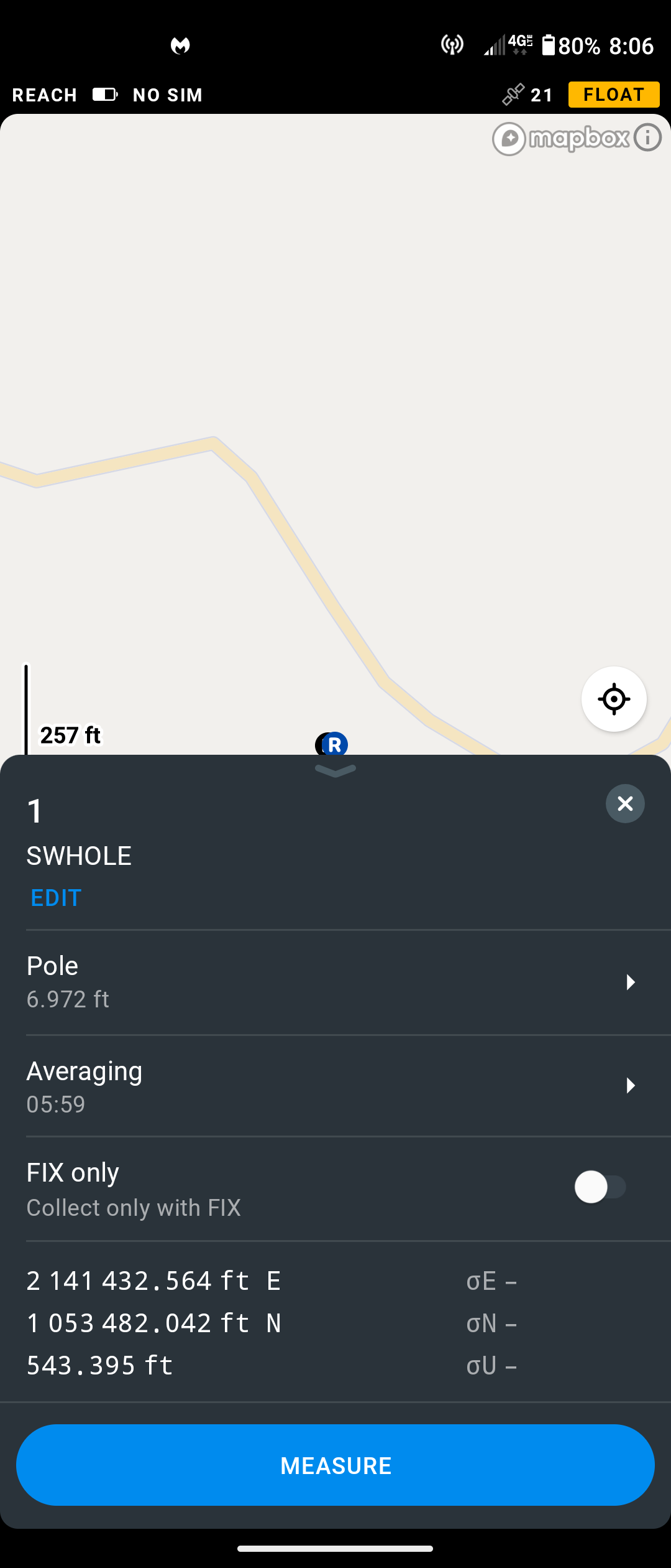
I’m sitting on a known point with my RS2 I’ve established, observed and verified numerous times with my JAVAD Victor LS T2. I’m using my SC RTN service and my fix is in and out to float because I’m in a high multi-path area.
This needs to be fixed to at least an hour of observation time. Maybe I’m missing something in the Reachview 3 app.
I was going to say that I thought an RS2 would do better than that for a fix, even with your POI directly adjacent to your house, north of it, and surrounded by tall trees. I figured would just be more trouble under direct covered canopy. But seems you have some open sky view.
But really to be fair, you cannot compare the Emlid to Javad. ; ) The whole you get what you pay thing.
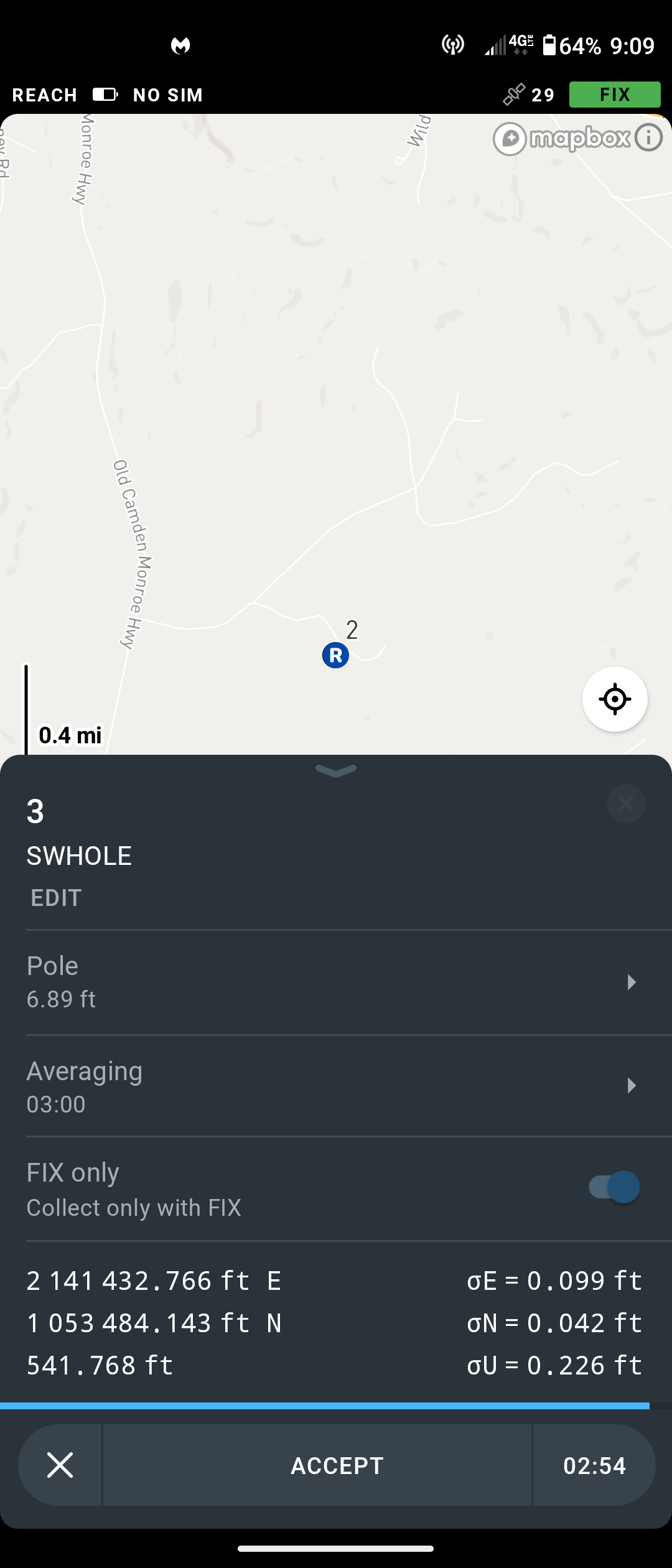
Little over 4" difference in horizontal of your 2 fixes?
Well, I’m not really comparing per se,. Just to establish the accuracy of the observed point. I like the RS2 and have high hopes for it. I knew the RS2 would have difficulty getting a good fix… It took approx 10 minutes to get a fix with the RTN and it was intermittent. However, I saw the number of sats increase and it finally got fix… I never did see the PDOP, that would be a nice addition to the page. I’m sure the PDOP jumped during the observation.
The “sigma” values appear a good indicator for a questionable fix, however you would have to compare with the previous observation. This is why I would like to see a “dist to last” function or indicator showing the distance and azimuth to the last point. This would be better comprehension for the user as he has an understandable indicator instead of “sigma” values.
I figured this applied mostly for the single band receiver such as RS/RS+. Figured not so much with multi-band RS2. Guess I’ll have to wait and see once I get a couple RS2’s.
I know you know all this, but just posting for users who do not:
This was basically an off the wall, Saturday night relaxing, GNSS observations party. Just something to do. Any GNSS receiver would have a hard time getting a “fix” solution at this point. Even my world-class Javad receiver has a hard time, but here’s the issue. Javad has multiple ways of verifying a RTK determined point. And you can bet your money that the point is correct based on your accuracy settings. This is what I want to see, some more verification of the RTK solution.
I thought I was already logging the “fix” in my settings and I was limited to my length of time (6 minutes) in the logging screen. Why have a six minutes logging limit ?
I usually do 3 x a 2-3 minutes spread over an hour for by the book RTK surveys.
For longer session i use raw and PP. From there you get all the numbers you want.
As workaround you could use the survey mode in the receiver (not survey mode in the app). It lets you start and stop whenever you want. Not sure if Emlid had another plan with the RV app, as this doesnt work there when you turn average off…
Btw, a really thorough accuracy comparison between Javad and Reach would be interesting to see
This is not really related to the topic but we tested ProPoint in our environments for about a week and it was not any better in the 3 places we always have problems in with our Topcon and it is definitely not as big of a leap as the 5800 to the R10 or the Hiper Lite to the Hiper II.
They were definitely pioneer and I believe the founder was a co-creator but in the commercial industry as we know it that was at Trimble back in 1983. To go back even further machine control at Agtek was before all of them in 1980 and led to much of the practical use that we have now. The company was officially founded in 1981 and much of their technology went into start Topcon when they were acquired “part” of Agtek in about 1994. This was a split in ownership and how Agtek went the software route focused on estimating. Truly I don’t think anyone really knows where the public sector use originated because of how tight knit the community was and pretty much everyone worked with everyone else back then. Even construction is similar today. The folks that have been in it for a long time know everybody!
Most of us here are not looking to spend that kind of cash on a receiver. I know I sure am not… but good to know what technology is out there, and what is to come in the future hopefully from Emlid. ; )
But yes, I do understand that some things are very expensive in order to lower the overall cost of business. i.e. having to traverse which may take much longer time and money and then having reliable fixed data where it just may not be possible otherwise depending on the situation.
“introducing the Trimble 4000-S, a 4-channel geodetic receiver, writing its entire software. It was the first commercial geodetic GPS receiver and no one can deny that it changed the survey industry irrevocably.”
It’s always interesting to follow your discussions. However, it seems to be my time to chime in.
Bryan, first of all, I’ll take your initial post as a feature request. Sounds fair enough.
Also, you’ve said that you’d like to have more values that help you verify an RTK solution. However, I want to outline that Reach solution is something you can rely on. We conduct a lot of tests and test each firmware to keep things that way.
If your experience differs and something goes wrong, we should not consider it as expected behavior. Please report such cases to us. To investigate accuracy issues, we need logs, CSV files, and Full system reports from your units.
Thank you svetlana !. As I said above, this was a simple on the fly test, even my Javad had issues getting a “fixed” solution at this point. As I’ve posted many times before, how can you verify a “fixed” solution and even trust the solution ? One way is to look at the sigma values the software displays. Obviously, the large sigma values in the second image indicate a poor solution. Another way would be to look at the PDOP values, again large values indicate a poor solution. It would be nice to have at the top of the page, next to the solution status, a PDOP value indicator.
As stated above, this point was in a high multi-path area. If fact, timd1971 even found the site and testified what he saw in the imagery. I really push the boundaries in what and where any GNSS receiver can go. Even though I’m always questioning any “fixed” solution, I also have the raw data to PP and verify the claimed “fixed” solution.
I’m not dissing Emlid in any way, shape or form. It was just a simple test. I really like Emlid’s products and want them to succeed. I’m just providing my input as a professional Land Surveyor.