


Given that the US actually is officially metric, why not continue with the metric? 
2 Likes
Hey everyone!
The first update for the app’s open Beta! Version 4.1 Beta is waiting for you in the Play Store.
We continuously improve app features and fix found issues, and your feedback improves this process drastically. Please, continue to report all problems, crashes, glitches, confusing things. Your help is extremely important!
And here is the full changelog for the update:
-
Norway vertical datum EPSG:5941(NN2000 height) became available, unlocking a bunch of compound CRSs.
Added vertical datums
- EPSG:5942(ETRS89 + NN2000 height)
- EPSG:5945(ETRS89 / NTM zone 5 + NN2000 height)
- EPSG:5946(ETRS89 / NTM zone 6 + NN2000 height)
- EPSG:5947(ETRS89 / NTM zone 7 + NN2000 height)
- EPSG:5948(ETRS89 / NTM zone 8 + NN2000 height)
- EPSG:5949(ETRS89 / NTM zone 9 + NN2000 height)
- EPSG:5950(ETRS89 / NTM zone 10 + NN2000 height)
- EPSG:5951(ETRS89 / NTM zone 11 + NN2000 height)
- EPSG:5952(ETRS89 / NTM zone 12 + NN2000 height)
- EPSG:5953(ETRS89 / NTM zone 13 + NN2000 height)
- EPSG:5954(ETRS89 / NTM zone 14 + NN2000 height)
- EPSG:5955(ETRS89 / NTM zone 15 + NN2000 height)
- EPSG:5956(ETRS89 / NTM zone 16 + NN2000 height)
- EPSG:5957(ETRS89 / NTM zone 17 + NN2000 height)
- EPSG:5958(ETRS89 / NTM zone 18 + NN2000 height)
- EPSG:5959(ETRS89 / NTM zone 19 + NN2000 height)
- EPSG:5960(ETRS89 / NTM zone 20 + NN2000 height)
- EPSG:5961(ETRS89 / NTM zone 21 + NN2000 height)
- EPSG:5962(ETRS89 / NTM zone 22 + NN2000 height)
- EPSG:5963(ETRS89 / NTM zone 23 + NN2000 height)
- EPSG:5964(ETRS89 / NTM zone 24 + NN2000 height)
- EPSG:5965(ETRS89 / NTM zone 25 + NN2000 height)
- EPSG:5966(ETRS89 / NTM zone 26 + NN2000 height)
- EPSG:5967(ETRS89 / NTM zone 27 + NN2000 height)
- EPSG:5968(ETRS89 / NTM zone 28 + NN2000 height)
- EPSG:5969(ETRS89 / NTM zone 29 + NN2000 height)
- EPSG:5970(ETRS89 / NTM zone 30 + NN2000 height)
- EPSG:5971(ETRS89 / UTM zone 31 + NN2000 height)
- EPSG:5972(ETRS89 / UTM zone 32 + NN2000 height)
- EPSG:5973(ETRS89 / UTM zone 33 + NN2000 height)
- EPSG:5974(ETRS89 / UTM zone 34 + NN2000 height)
- EPSG:5975(ETRS89 / UTM zone 35 + NN2000 height)
- EPSG:5976(ETRS89 / UTM zone 36 + NN2000 height)
-
Broaden ranges of available vertical datums for multiple horizontal CRSs.
Affected vertical datums
- EPSG:5941(CGVD28 height)
- EPSG:6647(CGVD2013(CGG2013) height)
- EPSG:9245(CGVD2013(CGG2013a) height)
- EPSG:5720(NGF-IGN69 height)
- IGNF:IGN69(NGF-IGN 1969)
- EPSG:5613(RH2000 height)
- EPSG:8266(GVR2000 height)
- EPSG:8267(GVR2016 height)
- EPSG:5711(AHD height)
- EPSG:5703(NAVD88 height)
- EPSG:6357(NAVD88 depth)
- EPSG:4440(NZVD2009 height)
- EPSG:7839(NZVD2016 height)
- EPSG:8089(ISH2004 height)
-
When you create an NTRIP profile, you will automatically receive a list of mount points provided by your caster.
-
Now, on the third tab, you can modify existing NTRIP profiles and create new ones even if the receiver is not connected.
Automatic mount points loading is not available here yet! You will be able to load them only through Settings while a receiver is connected.
We’ll improve this feature in future updates.
-
Now the third tab has been renamed to “Profile”.
-
Added “FIX only” setting that allows point collection only with FIX solution.
-
If the rover icon is not shown on the map, the “Follow” button now will be disabled as well.
-
Updated the connected device’s menu by renaming Settings into ReachView 2. Such naming should make clear what settings we refer to in the different parts of the app.
-
Fixed a bug that might have caused an appearance of negative zero coordinates in the point info and the collector.
-
Fix the hint for the Night mode switch on the Settings screen. Text now will be relevant for a connected receiver – we shouldn’t promise muted sound for non-RS2 devices.
-
Fixed some views that were ignoring the Android system Back button.
-
Since the previous coordinate system for the demo project required to download additional data, we replaced it with a similar one.
-
Selecting two coordinate systems from the list simultaneously could lead to incorrect behavior. This has been fixed.
-
Fixed potential app crashes that may be caused by CSV import. Unfortunately, we can no longer guarantee the compatibility with the ES File Explorer app, whose way of opening files differs from what we expect.
-
Add Russian and Spanish translations for more strings.
-
Minor visual updates.
-
Various fixes to ensure app stability.
Thank you for your time and your valuable feedback!
14 Likes
Thanks for your suggestion. We do know of this requirement.
I think the first step will be adding a satellite overlay. We will look into custom map backgrounds after the full release.
2 Likes
Thanks for the tip!
We’ll add it to our CS support roadmap. As with other cases, please share the following details about your workflow:
- What CS you use for your end results.
- What CS is your base usually referenced in.
- Links to any geoid or grid files you may be using.
- Some benchmark data before and after transformation from the base system to the target system.
You can send me a PM when you have the time.
Thanks! Waiting for your feedback 
@TB_RTK Can I ask you to take a look and verify the results? ![]()
Thanks!
1 Like
Sure. Test it later today
3 Likes
I suggest in future versions to add in stakeout mode the option to show the azimuth towards the point, this helps a lot when using the compass to locate the stakeout point. Thank you
3 Likes
Thanks for the tip, we’ll look into it.
1 Like
Oh, if only… (looks wistfully at the rest of the globe) 
Seriously though, with most of our references in a State-Plane coordinate system, that’ll help reduce user error and save time if we don’t have to convert reference positions to WGS84 in advance!
1 Like
Just tested with couple of points nearby and it was bang on. So far so good 
8 Likes
This application is designed for all modules? or only for the RS2 version. Congratulations.
One more update for the app – 4.2 Beta!
Thanks to the increased number of real-world cases, we were able to discover and fix some pesky bugs that eluded us for a while. Why not roll out a stability-improving update as soon as possible?
Some details:
- Unfortunately, in some cases, the application crashed when entering the receiver’s settings menu, now this problem has been solved.
- When creating or modifying an NTRIP profile, the already selected mount point will be displayed as selected in the list, as well as automatically scrolled to its position.
- Applied yet another bunch of internal fixes.
5 Likes
Hi @civil_ramirez!
All Reach models are supported! But you’ll need to use DEV firmware:
3 Likes
Hi Egor,
Everything is systematized and not so complex.
The most important thing is to add the obligatory CS in Poland. Here we have legal regulations.
http://prawo.sejm.gov.pl/isap.nsf/download.xsp/WDU20120001247/O/D20121247.pdf
-
**PL-ETRF2000** ETRF2000, European Terrestrial Reference Frame 2000, Ellipsoid GRS80, a = 6 378 137 m, flattening 298,2572221, -
**PL-EVRF2007-NH** EVRF2007, EVRF2007-AMST, 2007-AMST, European Vertical Reference Frame 2007, Normal Amsterdams Peil, NAP -
**PL-KRON86-NH** Kronsztad86, Molodensky -
**PL-1992** (Transverse Mercator Mapping Equations), 19°E (-5 300 000,00 m X, 500 000,00 m), 0,9993, Note: one zone 10°30’ for the whole country. -
**PL-2000** (Transverse Mercator Mapping Equations) (0,00 m - from the equator , 500 000,00 m + n × 1 000 000,00 m, n number zone ; 5, 6, 7, 8, 0,999923) Zone 5: from 13°30'E to 16°30'E Zone 6: from 16°30'E to 19°30'E Zone 7 19°30'E - 22°30'E Zone 8: from 22°30'E to 25°30'E -
**PL-UTM** Transverse Mercator Mapping Equations, 0,00 m from the equator, 500 000,00 m + n × 1 000 000,00 m, (n = 33 for 15°E, n = 34 for 21°E, n = 35 for 27°E), 0,9996
Conclusion: only PL-2000 (PL-UTM is not popular) and geoid models Kronsztad86 (valid until 2023) and Amsterdam (after) are enough for RTN (NTRIP, VRS)
If you have questions, I will additionally answer
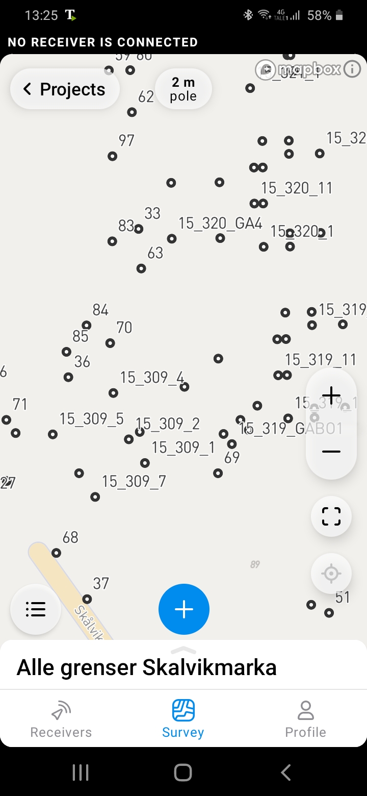
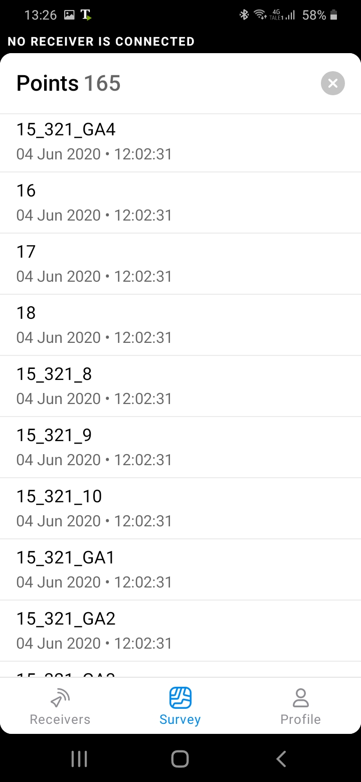
Possisble to import points with color feature. E.g add a coloum for color in addition to name,easting,northing
And it will show colors accordingly instead of just black circles in this map.
And/or add feature to point list.
4 Likes
When import csv points, is it mandatory to write the elevation of each point.
Some times I interested to stakeout only y, x
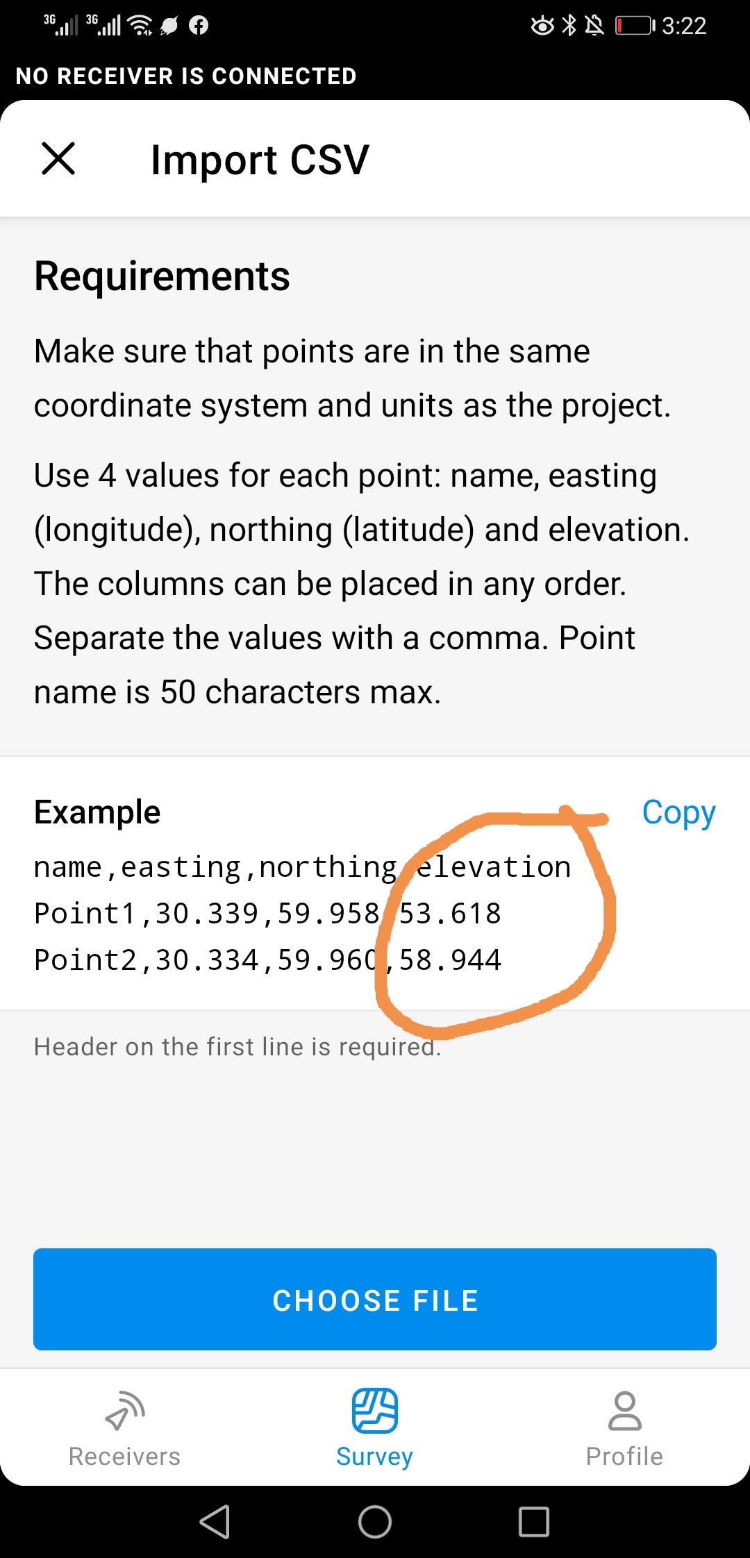
Such as demarcation of land parcel based on Autocad file.
1 Like
I haven’t tried, but point layering when bringing in individual point files?
I use zero elevation for points without elevation data
2 Likes
I reckon @bide mentioned something similar
1 Like