for sure it s already has been discussed but i can not found it back.
I have a point GCP
Using the last update of reachview 3 the height says 78,280m while exporting the same project the height is 78,639m.
Just to avoid any mistake i set pole height 0m ad adapter 0m.
Even trying to subtract the gps module 0,065 (RS+) i don t find feedback.
Quite an update for the Android app — 4.12 Beta is here for you to test!
@Nordstern Sorry for the full changelog being late this time!
Here is the list of new stuff:
We added support for a bunch of new vertical coordinate systems! This update includes CRSs for Austria, New Caledonia, Balearic Islands, Canary Islands, Ceuta, Alicante, and Slovakia.
We changed the default base CRS for some coordinate systems used in New Caledonia, Slovakia, and Romania.
RGNC91-93 is now used as a base CRS for IGN56 Lifou, IGN53 Mare, ST84 Ile des Pins, NEA74 Noumea, IGN72 Grande Terre, and ST87 Ouvea (New Caledonia)
ETRS89 is now used as a base CRS for S-JTSK (Slovakia)
ETRS89 is now used as a base CRS for Pulkovo 1942(58) (Romania)
Now, using CRSs that are based on these systems involves datum transformations with a horizontal grid or by transformation parameters.
The EPSG list was updated in accordance with the EPSG v9.8.12 and ESRI v10.8.1.
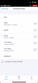
Serial and Bluetooth configurations are now editable in position streaming settings.
The correction output settings are here! At the moment, we have TCP and Serial wizards available, with others coming in the future updates.
Now, when you create or edit a project, NTRIP profile, or point, text fields won’t contain accidentally entered leading and trailing whitespaces or empty lines.
Awesome! So far it was already possible to connect the RS2 to the Collector and Survey123 app from Esri. Does this mean with the new Software I will be able to directly collect MSL (orthometric heights) rather then just HAE heights in Survey123?
We actually do have this geoid as an option. This geoid is tied to systems that have NAD83(2011) as a base coordinate system. In our app, these systems will be named like this:
NAD83(2011) / Some place or zone.
Please note that it means you will need to use a base station referenced in NAD83(2011) for the end results to be accurate.
Then choose the vertical datum to be NAVD88 and you should be good to go.
Just 2 cosmetic issues on the latest app and firmware on the RS2.
The latitude shows “N” in the southern hemisphere instead of “S”
The sim card status shows no signal despite this session running on a Ntrip correction over 4G
Great job! yesterday i tested it with the vertical coordinate system for Austria (GHA heigth) at wellknown points. It works really fine!
I have one wish. would it be possible to define my favorite coordinate system that automatically ist set for a new project!?
Hello!
Yes, in future i will always use the EPSG: 31256 (Austria GK East) as CRS and vertical coordinate system for Austria (GHA heigth) EPSG: 5778.
This will be my standards for the future. Maybe that sometimes i will survey in WGS84.
The easiest way would be to connect your base receiver to a different base (like a correction service) that is already referenced in NAD83 (2011) and average its position.
Also, if you have your coordinates in some other system, say WGS84, you have an option to convert them manually using some external software. We have plans to add this functionality to ReachView 3 in the future as well.
Gratulation for ara AUSTRIA!
Today I tested ReacVIew 3 Beta with emlid RS2 and APOS (Austiran Corretion Service with NTRIP) in area Tirol where you use EPSG: 31254 (Austria GK West) as CRS and vertical coordinate system for Austria (GHA heigth) EPSG: 5778. In XY I got with the BEV GIS GRID an error about 2-3 cm and in height 10cm (can be corrected in antenna offset) which is very good. Point was near house, so there could also be an error of 1-2 cm.
Whishes for further functions:
use of 7 parameter to make the best fitting in local coordinate system
more possibilities for attributes
support of WMS or WMTS (so we can get Geoland or other orthoimages as basemap too)
support of WFS-T or ArcGIS Online Web Feature Services
But you are in a very good way to make emlid doing very well!