Consider heating as a problem as you fly in Ivory. We’ve got problems in tropical area : Indian Ocean. Read the doc we built, with others, here about heating :
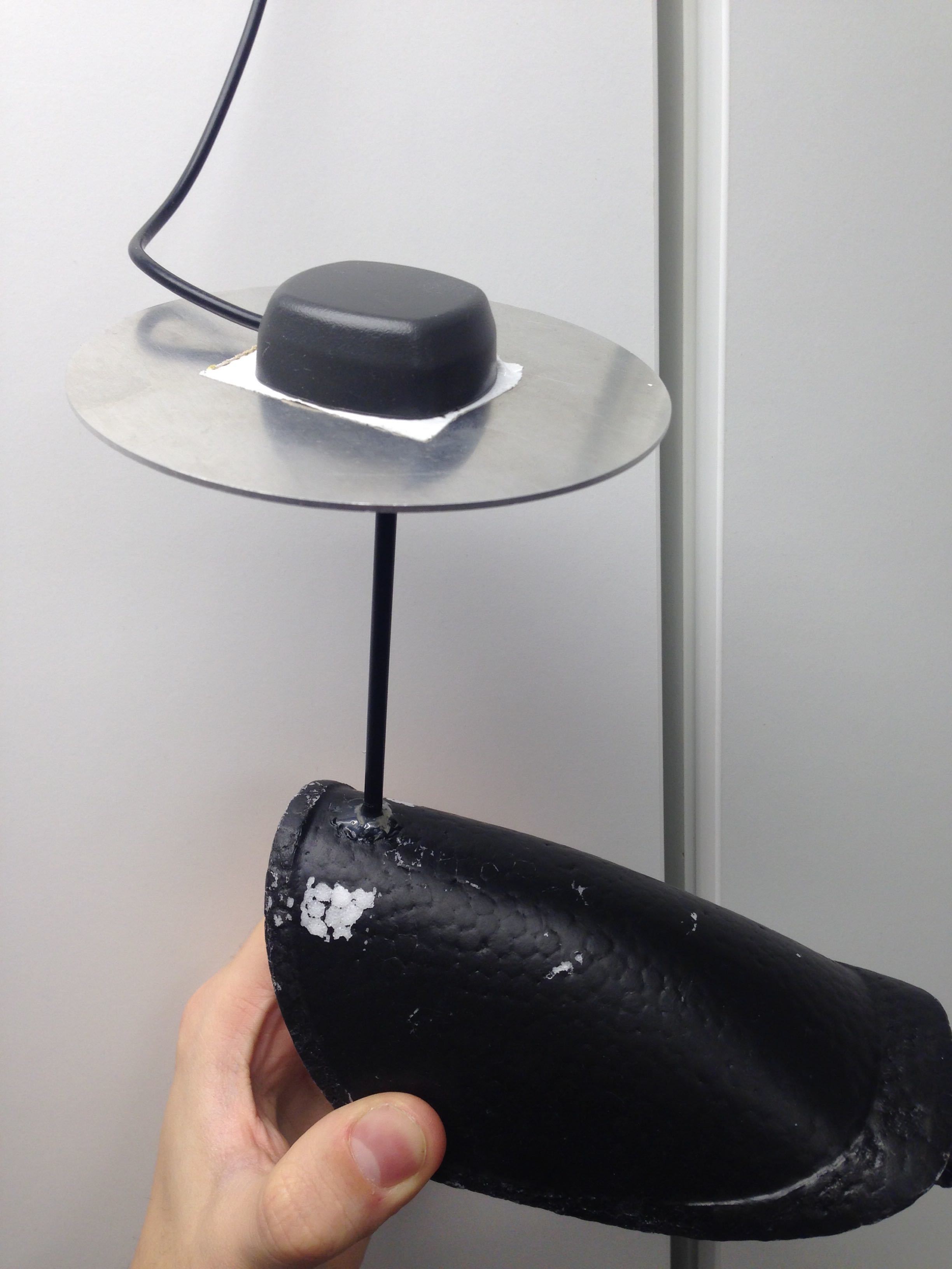
About the ground plate what if I use a flat surface on the nose and some copper tape like on this picture? I can isolate the antenna from direct sunlight by hiding it under the white cover
This type of antenna installation is not right. Also, according to your logs above, it causes a bad satellite view and cycle slips. As a result, it can be a reason for losing time marks.
You need to do ground plane for your antenna and install it as far from sources of interference as possible (ex.on the pole).
About raising the antenna using a pole on this plane might be tricky, but if the result are still not good, why not trying, I just hope I don’t have to.
edit : By the way, I am still using GPS only at 10hz
edit 2 : For Africa, what setting do you recommend, GPS + GLONASS + QZSS or GPS + GALILEO?
I moved the video TX way back under the belly and the camera under the nose, I installed a big ground plate under the antenna and finally the reach is powered by a 2.5Ah powerbank.
And you can also find bellow the log of the reach m+ outside with and without cover with my new setup, I looked at them RTKPLOT and the result looks good:
I think I have enough with this system, I have been on it for 2 months, tried a lot, even putting the antenna far away from the drone like here : https://drive.google.com/open?id=1PxuGi7zc_jsLBQrYSvO5lDA0NgPg9Y-z
Using a ground plate, installing an external power source, changing placement of everything over and over again and still missing photo,13, even more than when my setup was at the worst “the beginning”, 4-5.
I would be happy to get all my pictures geotagged, even if the accuracy was 40-50cm or worse, I could start to fly and make the setup better overtime, but here no, I always have the same problem, and start to be sure that if my system is not 100% perfect, I mean 100%, it won’t work.
You will find bellow my logs, not sure if you will find anything new.
I can give you my address if you want to get rid of it… .
My antenna is 5 cm away from my autopilot and 10 cm from all the rest of the electronics. It is working without any problems (not one missing time mark in >25,000 images) eventhough the signal to noise ratio might be better if I would move it further away.
I would get rid of the electronic garbage in your plane and just use the things absolutely necessary for mapping. Get high quality BECs. Try to use a optoisolater between the camera and the flight controller.
Right now, I have a 20cm mast I could use, screwed on the top of the drone, but if the supplied antenna cable is not shielded, it will not work. I am in Ivory Coast, meaning that ordering parts, even from europe takes forever.
Here we go a bit too far, I wasn’t expecting a plug and play system, but install special electrical system, modify the UAV and use many software steps just for it to work, it’s not worth the time in my opinion, I should have started my flight months ago and now it’s raining season. I prefer to spend 10k$ for something that is working out of the box.
I think it is working out of the box. The problem is your plane, not the RTK module. I don’t think spending more money will help if your environment is bad. If you need to go mapping you should prioritize that.
I don’ think even a 2 m pole will help as long as the environment in your plane is that bad. You have to fix that first.
People at Foxtech are using spiral antenna mounted on top of the UAV, I am not sure they modified anything else, so after installing the mast and the spiral antenna, it should work 100% right? I wish it, but my hope are not high.
No, you should improve your environment and if the system is working you can think of changing the antenna. If it is not working when the antenna is 1 m away from the plane it will not work even if you mount a choke ring antenna… .
You need to improve your noisy environment and isolate the RTK module from the rest of the electronics. Just start with a 0.1$ optocoupler with an arduino.
While regular GNSS for navigation might work just fine on your craft, RTK GNSS systems are in another league. The signal quality needed for the centimeter accuracy is demanding! Emlid recommendation on signal-to-noise-ratio is 35 dbhz, but in most official docs I see it stated to 40 dbhz. Even on the ground 35 dbhz isn’t trivial to obtain. Put it on a platform with lots of RF transmitters, and you have a recipe for noise.
You need to think about your other antennas as well, and how they radiate (their orientation), and at what frequency.
If you are using cheap China video transmitter, consider shielding them harder, or replace them.
It is not terribly complicated. You need an optocoupler for the camera release and an arduino and an optocoupler between the hot shoe and the timemark pin.
Optocouplers connect the one side if the other side is driven high. The control side is basically an led needing an resistor.
The Ardino needs to sense the flash synch and then drive the optocoupler high for a certain amount of time e.g. 10ms (you could correct the offset with my time machine).
The Sony cameras are released if you connect specific pins. The optocoupler will do that for you. You need to connect the optocoupler to a relay output of your pixhawk and the other side to the camera release cable.
And yes, get rid of the fpv stuff, you don’t need that for mapping.