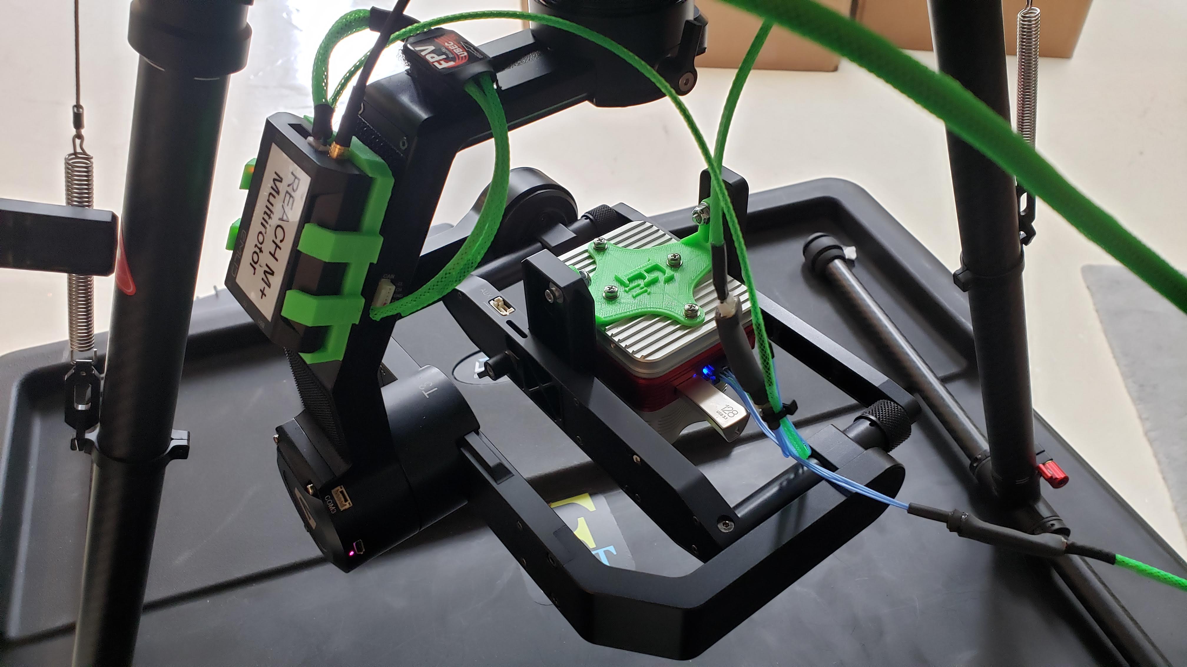
I have a strange occurrence with PPK setup we have been testing. I want to get higher accuracy PPK locations of multispectral images collected with a MicaSense Altum Sensor. I designed and 3-D printed a custom sensor mount for the Altum that mounts to a Gremsy T3 gimbal, and also printed and mounted the M+ to the back arm of the gimbal. The Altum wiring was configured to send a pulse to the M+ at each MS imagestack event. It was tested sucessfully. The green wires are all custom power and sensor wires.
All data was downloaded and processed using EMLIDs rtkconv and rtkpost apps using the recommended settings found online. When I compared the number of MS image stacks recorded on the Altum to the triggered events on the M+, both flights were short events. I had 462 image stacks for the first flight, with 434 recorded by the M+, and for the second flight 437 image stacks and 409 tiggers. Both flights had 28 images more than trigger events. Anyone have any ideas? The UBX base is too large to post here so I will email it directly to support. Thanks for your help.
Did you check for cycle slips in your observation data (as written by @RTK_Hunter below, cycle slips my be the reason why no events are recorded. Cycle slips might be caused by electromagnetic noise emitted by the uav. )? I’m writing on a script to interpolate positions for missing image events.
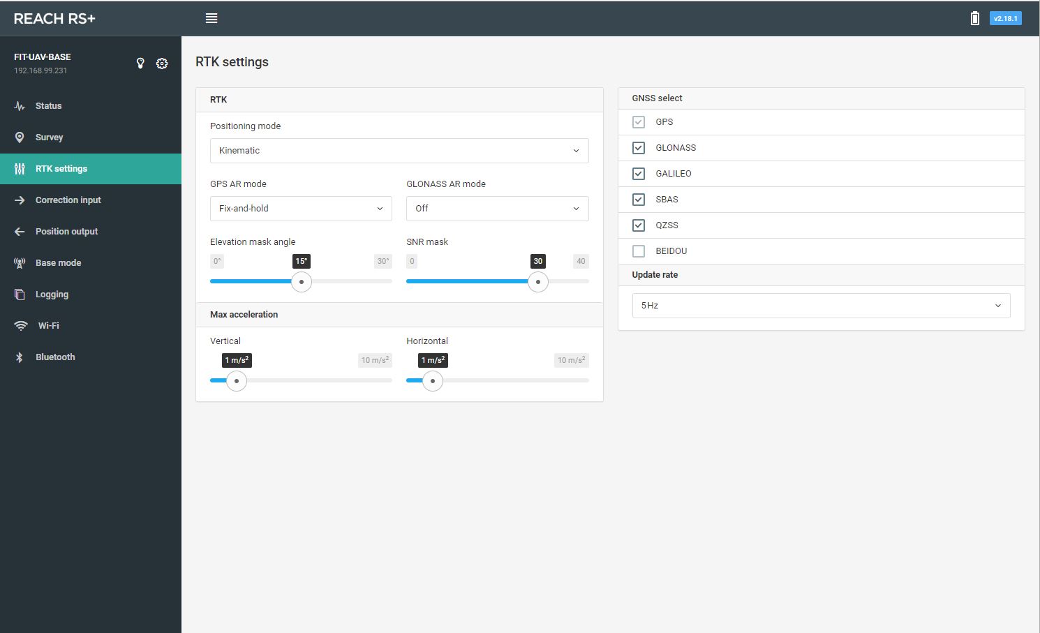
Your RTK settings are not the recommended ones for timemark logging.
The images were auto triggered by the Altum to allow for 80% frontlap and 80% sidelap. The flights were conducted at 120 m static altitude above ground surface, at a velocity of 10.7 m/s. The max image rate for the Altum is 1.5 Hz. I have not investigated where the missing images are from yet…
5 Hz and satellites according to your region. Maybe GPS and Galileo. I used GPS + GLONASS + QZSS for a long time but the GLONASS data quality was always lower then the GPS data quality. I will try GPS and GALILEO from now on.
There are many experienced people at the US (e.g. @RTK_Hunter & @michaelL) so I guess they will come up with good advice.
Sorry @RTK_Hunter, I did not realize you are situated in US too, all this names with RTK.
I currently run GPS, GLONASS, Galileo and SBAS. I have yet to try Beidou in my area as @timd1971 has brought up. By running all I can view the statistics during PPK and remove constellations if they are weak. Since running the Emlid equipment I have seen that there are some fairly consistent issues with GLONASS. Central Texas here.
I emailed the UBX logs to you directly, individually they are all smaller than the 20 MB limit. Is there a way to post process the current data that I have, or will I need to change the GNSS selection and Update Rate? For Montana in the USA what would you recommend as a starting point? GPS only at 10 Hz, GPS/Galileo at 5 Hz, or GPS/GLONASS at 5 Hz? Per Tobias recommendations I will try the next data collect with GPS/Galileo at 5 Hz.
OK thanks everyone. We will try the GPS + GLO @ 5 Hz for the next test. Regarding the GLO AR Mode…Off or ON?
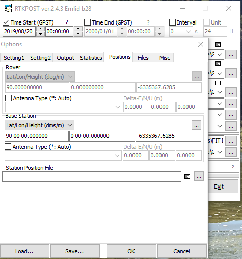
Another question…When post processing the data, if we setup the Reach RS+ head on a 2 m pole on a known surveyed location. Can this be entered in the RTKPOST app in OPTIONS --> POSITIONS? Enter the DMS for the Lat and Long of the surveyed point? Would the Height be the elevation of the point on the ground or ground elevation plus 2.087 m (2 m for pole, 0.022 for the 1/4" to 5/8" adapter, and 0.065 for the distance between the bottom of the Reach RS unit and the center mark).
GLONASS AR should be on. I would highly recommend turning on Galileo as well. As long as you have 3 good satellites you are getting triangulation and they can always be dismissed in processing.
If you have 2 units you could test GPS and GLO vs GPS and GAL. I think the second is the better configuration. @wsurvey recommends to use BEIDOU as well (GPS, GAL & BDU) and fix probably missing events in post processing. He recommends GeoAdjusd which works for P4P images from DJI and I have writtem a tool to match images and events regardless of the camera manufacturer and the time settings. I have greatly profited from @wsurvey earlier recommendations and will adapt these settings for my next campaign. I will have the possibility to check against a Leica device and will report.
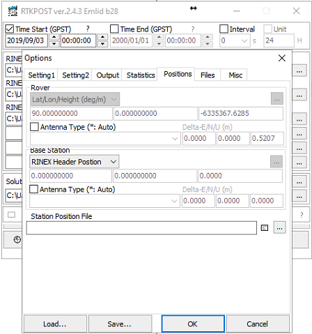
I performed 12 flights over two days last week with the Altum and the Reach M+/RS+ system. I plan to begin the Reach processing today, then import the data into Pix4d for processing. I have a question regarding setting the RS+ antenna height in RTKPOST ver 2.4.3. I am in OPTIONS window as seen below:
I have the coordinates of the base station location collected from an L1/L2 GNSS CHC system, processed in OPUS in the USA. I have the Easting, Northing, and Orthometric height of the surface point on the ground where the base was located. I put my RS+ on a 2 meter pole at this location. If the ground base location is 1531.0145 m (orthometric height) should I enter the height in the Delta U as the ground elevation, ground elevation plus 2 meters (for pole), ground elevation plus 2.022 (2 m for pole and 0.022 for 1/4" to 5/8" adapter), or ground elevation plus 2.087 meters (2 m for pole, 0.022 for the 1/4" to 5/8" adapter, and 0.065 for the distance between the bottom of the Reach RS unit and the center mark?
In addition for the Easting and Northing location to I enter this in the Delta E/N/U (m) field or in the Lat/Lon/Height (DMS/M) field? I tried entering this info in the Delta E/N/U and recieved an empty position file from the output. Thanks everyone for your help.