


I think this is it. Does the EPSG code change between realizations? If not, how can I get the correct transformation in QGIS?
It could.
I just jumped in to this thread and haven’t read what your issue is?
I was trying to figure out how to tackle the problem that arises from the fact that:
RS2 logs in ETRS89 (corrections from NTRIP are in ETRS89) and
M+ is logging in WGS84…
Exactly. This is where many confuses the coordinates system the receiver is using and what your e.g ntrip is using.
If RS2 is receiving data from ntrip and ntrip states its using ETRS89, then the coordinates you get from RS2 will be displayed as WGS84 lat/long or ECEF BUT “adjusted” for the ETRS89 system.
And the same for the M+. It will be whatever the base is using.
Even without RTK?
In RTK it will use what base use.
If you PPK M+ with base data it will be in the same system the base use.
If you don’t use any correction, M+ will show you Reach native system WGS84 the original in lat/long or ECEF
1 Like
If you look up epsg code 4326. You see that’s the original WGS84.
WGS84 latest realization has a different epsg code. Just check in qgis or epsg.io. and see for your self.
Ok, that sounds good. Did I misunderstood the response from emlid support?
…
Or does it mean that if I dont do transformation, the position after ppk will simply bebin Etrs89?
Just use rtkpost of RTKLIB like this :
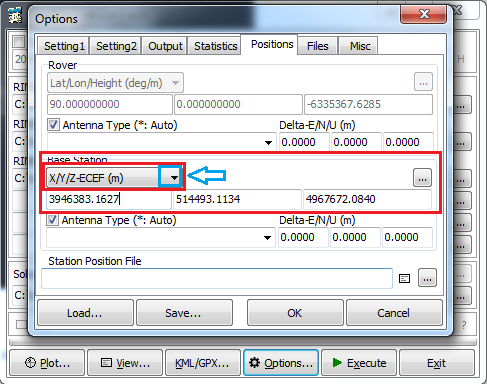
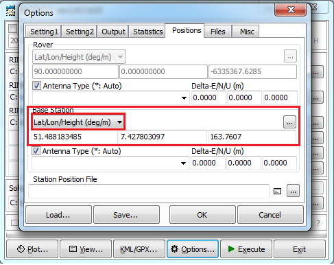
Use the arrow to change from X/Y/Z-ECEF to Lat/Long/Height
1 Like
I am not sure. What was your question?
But maybe easier to tell in what datum you need the coordinates in?
Shallmİ do this also if İ am ok with the data being in the crs/datum of the ntrip caster OR only if i need the data to be in WGS84?
I dont mind wether it is in WGS84 or ETTS89…
Ok it seems Emlid answered for both scenarios. If RTK then you don’t need to do anything.
If postprocessing, then manually fill coordinates or use rinex header if base data is present.
1 Like
The Cartesian coordinate frame of reference used in GPS/GLONASS is called
Earth-Centered, Earth-Fixed (ECEF)…
http://www.satsleuth.com/GPS_ECEF_Datum_transformation.aspx
1 Like
Yes. GPS,Glonass, Galileo Beidou use ECEF in their ephemeris broadcast.
But GPS also broadcast WGS84 the original and the latest realization.
These parameters along with the argument of the perigee, ω, and the description of the position of the satellite on the orbit, known as the true anomaly, provides all the information the user’s computer needs to calculate earth-centered, earth-fixed, World Geodetic System 1984, GPS Week 1762 (WGS84 [G1762]) coordinates of the satellite at any moment
1 Like
Ok, all seems clear now, except the transformation from ETRS89 to WG84. When the conversion returns same output as input, it would not make much sense to put in the base coordinates converted manually instead of using the base data as is (for PPK of Rover coordinates).
So what I will try to find out tomorrow, is the the realization of ETRS89 that my SAPOS corrections are being delivered in…
If your local datum is something like mine (ETRF89=EUREF89) and your transforming parameter for WGS84 is similar.
The WGS84 will state a transforming accuracy for geografic coordinates to be +/-1m. Wich is less accurate then actual local point that could be 0-100cm away. Transforming geografic coordinates is not 100% accurate.
If you compare the defining parameters for WGS84 and ETRF89, they will most likely state 0 or equal in Qgis.
Check out WGS84 and difference between geocentric, geodetic and geografic WGS84 datum
I showed a step by step transition from WGS/ITRF to EUREF89 (based on a master thesis somebody els wrote) taking the earth`s change over time into consideration. This is just a step by step .
I can run all this in one batch with a dedicated local transformtion tool (SKtrans) with just two click but the point was to show there is more to transition then just convert it from XXX to XXX.
As you can see, it doesnt cut it by just use WGS84 to ETRF89. The defining parameter isnt good enough. Qgis could probably do it but i havnt found a way yet.
I guess that you need a tool that does it for you. Problably the top brands out there does it.
So, with the latest QGIS version comes proj6 which can handle epochs of the same CRS. Just as an update to where QGIS is… The functionalities are usable with GDAL convert format and I am currently experimenting with it… I am close and will post an answer when this Odyssey is finished…
1 Like