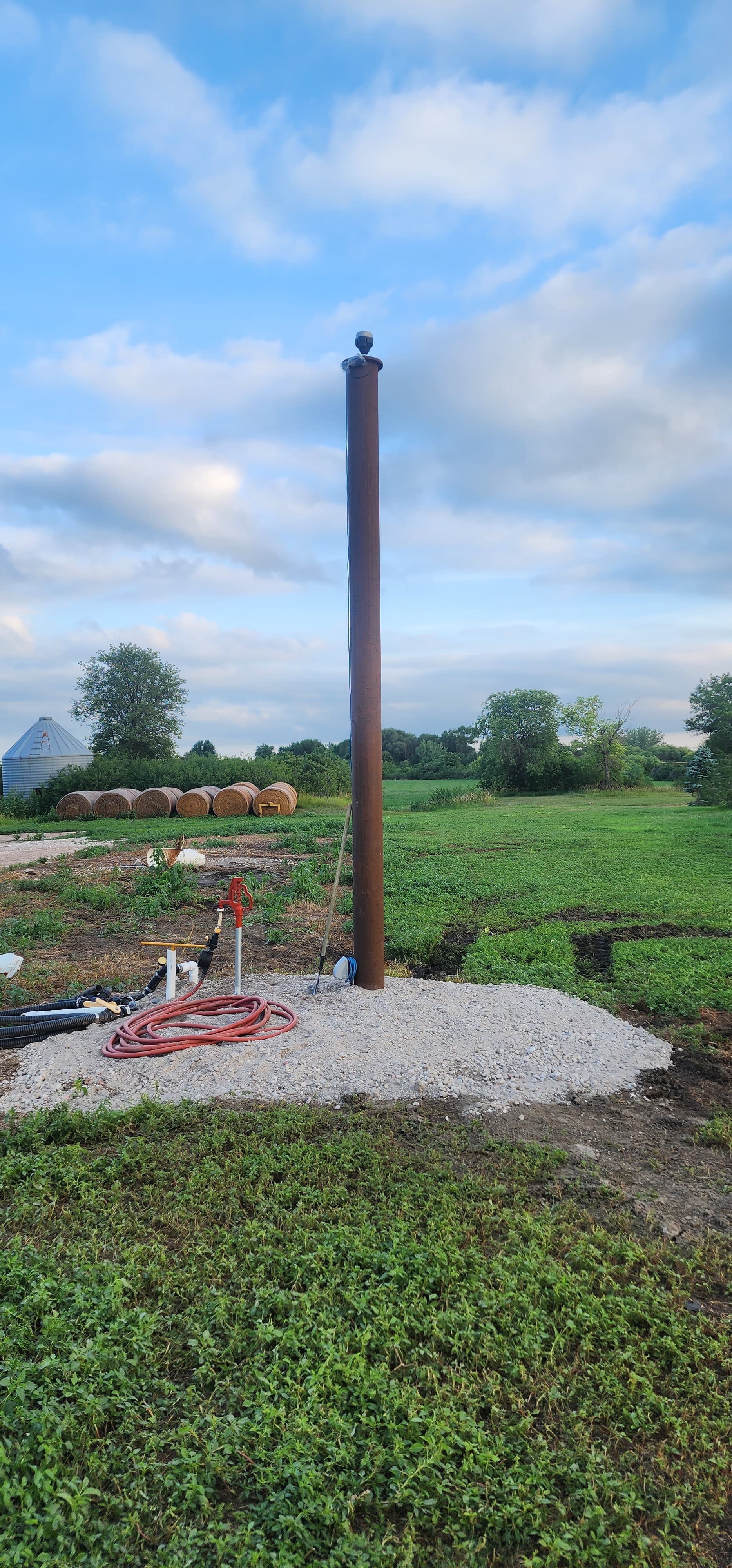
Hello, just got my pole up to set upy new RS2+ on it for permanent, year round use for our tractors running Autosteer. Pole is 20foot long with 5 foot concreted into the ground. Couple of questions on this.
If the pole is 15 foot plus a 2 inch poly sticking out on top, do I plug in 15ft 2in into the antenna height setting?
2nd the pole is as level as a 4ft level can tell me but that still can be off. How important is it that my base is perfectly level? Do I need to purchase a 300 dollar monument adjustable mount?
3rd. Does the direction of my base matter as I spin it onto the bolt? I’m sure this does not have an affect on anything, but since I’m installing this once I want to make it correct.
No, just enter “0” for the base of the RS2+. You don’t need ground elevation and I doubt you could get an accurate height to the ARP of the receiver. What would be the reference point at the ground ? NGS CORS uses the bottom of the antenna, check out some data sheets for the CORS. You’ll see “0” for the ARP .
No, the pole mount may not be actually plumb but again if the mount structure is stable per your description there would be no issue as you are using the base of the receiver as the reference point.
No, not unless you are performing precise geodetic work. NGS references the receiver NRP (North Reference Point) at the MMI (Man Machine Interface) , i.e. the receiver on/off indicator face. If you are performing precise geodetic work, all receivers should face north as that is what the calibration numbers are referenced from.
Great mount !! I would consider some kind of plexiglass enclosure though for the RS2+.
Thank you for the reply. A plexiglass enclosed won’t affect the line of site? Glare? Corners or edges of the box? I agree this is too nice of a unit to just leave out 24/7…but if this works like we want it’ll save us $6700 a year on RTK subscriptions from our caseih Titan dealer. But needs to be reliable and 100% uptime which it should.
I guess it wouldn’t matter, it’s rated IP67 water proof up to 1 meter depth.
I just hate to see survey equipment in the weather. I’m sure it would be okay. They make covers for our Javad T2’s if used as a permanent base station. If you did decide to make a cover, the plexiglass wouldn’t affect the receiver . When I think it’s going to rain, I use a Ziploc bag for all my receivers, Emlid’s and Javad’s.
That is a serious pole for a gnss receiver base station !
Adding context to what @EBE111057 replied. For your base, your receiver location just needs to be stable over time (looks like you have that covered) and the point of reference can be anything so long as it doesn’t change. Therefore, the base of the receiver (ARP) is the logical choice. You could PPP several 48 hour observations over a month and average them and you have your coordinate up on the pole at the base of the unit. Your rover’s don’t care that the reference point is up there.
So I have tried and experimented multiple things to get my coordinates last few days. I have tried the average fix for 30 seconds…it will not let me do average fix for over 1 min. I kicks me off fix into float or single. And the only way I can get a fix on my base in the first place is by putting my NTRIP credentials in the correction input. Unsure why this is.
Anyways the avg fix coordinates did not work. My AB lines were still off. (Using trimble equipment in my tractor. AB lines were made from Trimble RTK base station) the AB lines we have are very old. Back to 2008. So we would like to keep running on the same lines…and have over 250 AB lines made)
I have also taken the trimble AG25 antenna globe off of the roof of the tractor and strung a cable from tractor FMX monitor display to the globe to get it’s coordinates then inputed those coordinates into the emlid. NS AB lines were off 9.5". EW AB lines were off 4’2".
So from there I started adjusting the coordinates myself until I matched my original AB lines. It’s very interesting changing coordinates in the emlid and watching the “offline” distance change on the trimble monitor in the tractor.
So far it looks like most of our AB lines on most fields are matching up fairly close.
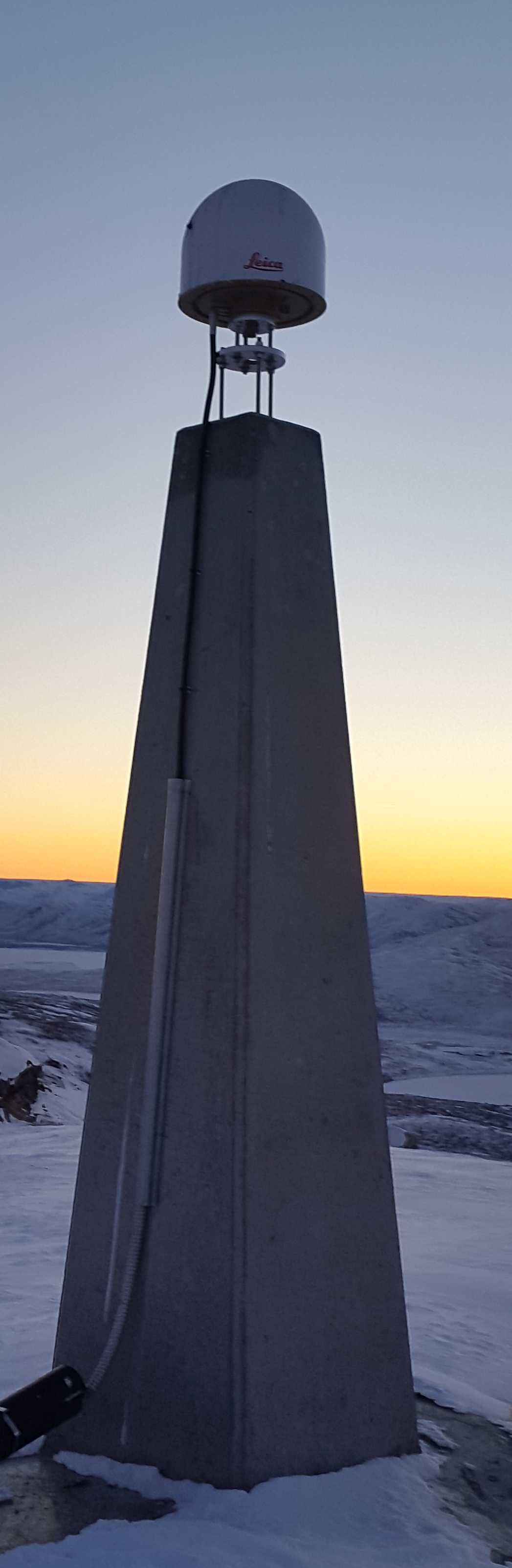
Here is a picture of an antenna I use in Greenland with a lot of snow and ice in the winter.
Antenna stands on a pyramid cast in concrete and anchored in bedrock.
Antenna is protected under a fiberglass radome.
You are referring to getting a coordinate for your new base, correct? You are going about it wrong.
What you want to do is a post process called Precise Point Positioning (PPP).
For PPP, you need to ensure that your receiver saves a log file, and if you use the OPUS service, select the OPUS preset in the settings. OPUS can process up to a 48 hour log so long as it crosses no more than 2 GPS days. However, emlid receivers maximum log time is 24 hours.
After you receive the adjusted coordinate from the PPP process, you enter that into your receiver’s base setting, Manual coordinate. And then your can feed corrections over NTRIP to your tractors.
You could alternately establish your base’s position by first setting it to be the rover and use your existing NTRIP service to find it’s position. But, ultimately, the PPP workflow, done several times over the course of a month and then averaged would probably be better.
Curious though, for this application to get things going faster, since baseline accuracy between the BASE and ROVER is always cm accurate. If the BASE’s stationary point is AVERAGE SINGLE (autonomous) for 5 minutes, can he just record that averaged point to use here on out and run with it? (or better yet, after physically recording that averaged point of the base, plug it in (SAVE BUTTON) as MANUAL so can set it and forget about it for daily operations?)
Note: max antenna height is 6.5535m (21.5’) (your pole is under that, but getting close if you decide to add extension for whatever reason) ; ) But I think you can enter 0 as @EBE111057 Bryan mentioned though?
Going with an averaged single position for the base will provide relative accuracy for his project, true. But it will likely not align well with his previous lines set while using a commercial NTRIP service. He will likely need global accuracy for that.