Understood… good point about the previous lines set.
Might as well go through the PPP process so he has a permanent point record. (or the NTRIP/set Base to Rover temporarily method you mention if quicker)
Understood… good point about the previous lines set.
Might as well go through the PPP process so he has a permanent point record. (or the NTRIP/set Base to Rover temporarily method you mention if quicker)
Yes I am talking about new coordinates for my new base setup. I am unsure how to go about using the PPP method, as to where to get the program and steps to start it. But I understand what you are wanting me to do. And I understand I have gone about all this the wrong way to determine coordinates. But the coordinates I came up with by myself by manually adjusting each digit of the lat and long until I matched up exactly to my existing AB line…I mean it worked. And if I have any other coordinates than what I have saved in the emlid now…my tractor will not drive exactly down our existing corn rows (AB lines). I am very curious though to see if the PPP method would give me similar results and am willing to try that out.
Is there a known physical mark for that circa 2008 base?
Yes the existing base has been officially surveyed in and has been in use since early 2000s with repeatability every year since. Nearly 50 or so rovers(tractors, scrapers, sprayers, combines) have been running off this trimble base with the area farmers. The guy operating and maintaining this base is an official trimble dealer, so everything is set up and surveyed in to specs.
Thank you Matt for your reply.
If the Trimble base logs data, see if you are able to obtain that data in RINEX format. You will want to investigate and inquire about the metadata, paying attention to the reference frame, it’s particular realization and epoch; e.g., NAD83 (2011), epoch 2010.0000. Related to the reference frame information will be the explicit projection system that is being used, for example, it is possible that the projection is geographic; i.e., lat, and lon; but more than likely the projection will be either state plane (e.g., Nebraska, EPSG:26582) or UTM (e.g., UTM14N, EPSG:32164). Pay attention to the units. The next aspect of your metadata hunt will be focused on finding out the Trimble base’s height information and in particular, which geoid model is being used; e.g., Geoid18.
Once you have this metadata, begin logging data on your RS2+ perched atop the pole (props for that!) for later post processing in Emlid Studio. As Dave and Bryan already suggested, log your static observations for several hours and over several days, but before you begin, be sure to set the logging interval to 30 seconds. It’s not critical that every logging session be a certain length or that there are gaps of any amount of time between these logging sessions. What is critical, however, is that the Trimble base is also logging at the same times as your RS2+
I would also suggest that you just try following this procedure with small datasets once or twice to see the process of post processing from start to finish. That procedure is already well document in the Emlid docs, but if you get stuck, feel free to ask questions on the forum or through support@emlid.com. Once you feel good about the data gathering and post processing workflow, then do the longer static sessions.
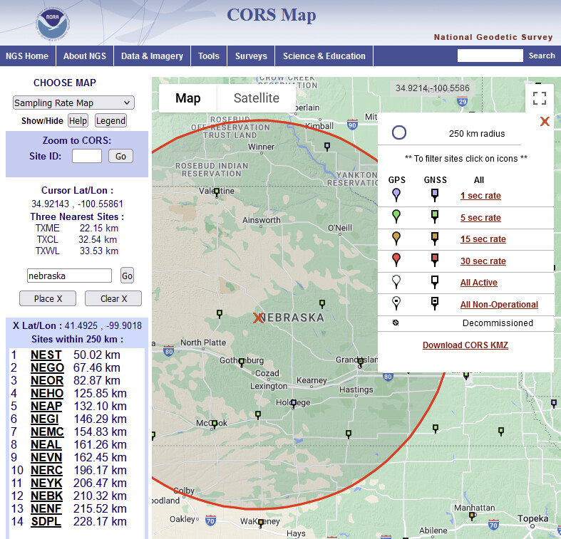
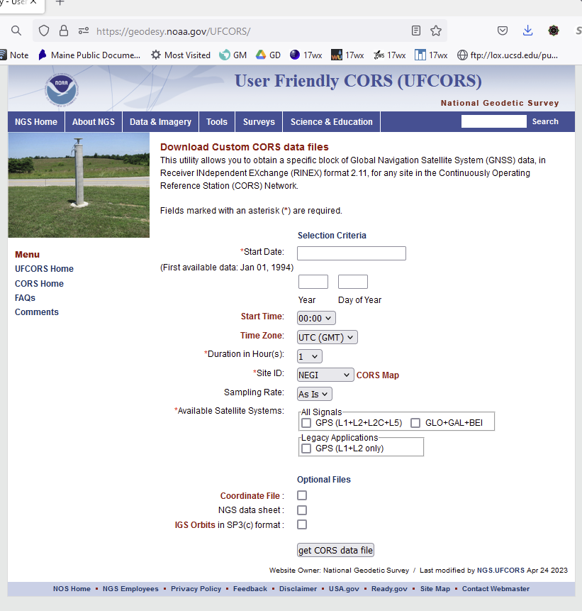
Hopefully the Trimble base is within 10 km of your perched RS2+ and you are able to download data from it, but if it isn’t then you may want to consider using additional and/or alternate data sources such as NGS CORS; e.g., NEGI.
In regards to the earlier discussions above concerning enclosures:
once you’ve gotten a solid post processed position for your RS2+, install the enclosure and repeat the multi-hour multi-day static sessions to make certain there’s no issues being introduced;
mitigate any heat build up caused by being in direct sunlight; e.g., white enclosure, screened bottom to keep nesting insects out;
consider placing a lightning rod if you anticipate such strikes, but in any case make sure your well grounded, and it would hurt to ask what, if any lightning precautions the Trimble base employs.
As for one type of enclosure that I would try starting with is a dock piling cap; e.g.,
Just curious about this agriculture stuff, do you know if there are any of the folks using the Trimble base RTN services tracking all constellations, bands and frequencies? If not, that’s okay. When you download the RINEX file from the Trimble base, and if you’re curious, the tracked satellites will be indicated in the top lines of its header.
On your own tractors, what SVs are they seeing?
If you are already using mapping software for some of your farming aspects, consider loading other data as an independent sanity check and corroboration.
I should have included the caveat that the dock piling cone DIY radome is not approved by NGS - thank you Bryan for making me think it should be mentioned ![]()
From NGS guidelines:>
C.2. Antenna Radome
NGS strongly recommends that no antenna radome be used.WHY: It is well documented that an antenna radome changes the antenna phase centerposition. Its benefit is limited as antennas are constructed so they do not need the“protection” of a radome. The choice of material used, the effects of UV radiation, as well aspossible manufacturing inhomogeneities in the thickness of certain radomes, may createadditional problems in using a single Phase Center Variation (PCV) model for a particularradome model. These two problems imply that either a time-dependent effect on the PCVexists as the radome deteriorates or a calibration of each individual radome is needed as a general model calibration would not be valid.
If a radome is used, the antenna and radome pair must have an IGS absolute antenna calibration (see C.1. Antenna).
Thank you very much for all of your info. I am unsure if I can gather this date from the Trimble base but I can ask and see what he thinks. He may think that since my “made up” coordinates are working with our existing AB lines just run with it. I say this because it seems like every single other NTRIP service I have tried have been off as well. Our temporary Case IH Titan RTK+ NTRIP service comes from a base located in the top of our Case IH dealers shop 5 miles from me. This site has been officially surveyed in as well and every single line has a 2 to 4 inch shift. Just varies on each field. So that tells me…no matter how hard I try to get log files processed ( which I have never done before) it seems I’m going to have some sort of line shift. People running on cors network have same problem I have heard.
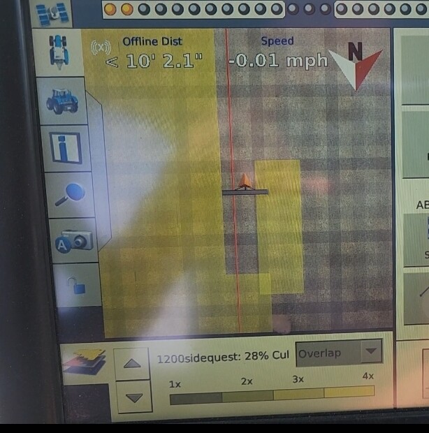
My method on how I determine a line shift on our trimble monitors in our tractors…
I simply lock on to an AB line in the tractor (using the local trimble base) and drive until I’m dead on a “zero” offline distance ( exactly centered on the line).
Then I simply disconnect the RTK antenna retrieving the base corrections, and it automatically switches to our sierra wireless modem which gets us out NTRIP service into the cab. As I do this, the offline dist. will change from zero to whatever I’m off on the existing base I’m connected too.
Thank you Matt for the reply.
As I’m sure that you’ve already guessed, unfortunately I have never seen the inside of a tractor with all of its fascinating GNSS gear; receiver(s) and display device(s), nor have I seen the outside of a tractor with all of its GNSS related bits bolted onto it; communication antenna((s) (spread spectrum?)), GNSS antenna(s). Are there any other GNSS related bits inside or outside? So you really should talk with a local land surveyor familiar with GNSS and agriculture automation. I’m just a Maine dirt surveyor!
Before and after the disconnection from one means of communication to another; e.g., from spread spectrum to cellular, for your tractor’s receiver’s RTK corrections, are you always connected to the same NTRIP service using the exact same physical reference station (mount point) and are you in both instances receiving corrections and getting fixed positions?
Should the bridge of the mustachioed nose (icon) be on the red line and always on the red line, the so-called AB line? ![]()
Is the Trimble base not the same as the “temporary Case IH Titan RTK+ NTRIP service comes from a base located in the top of our Case IH dealers shop 5 miles from me”? Regardless of the number of NTRIP service providers, they all should be more than happy to provide you with the metadata (as described in detail above) for their base station(s). You may be able to find it on their website(s). Knowing this information is fundamental and required before post processing your own data if you intend to be on the same frame, realization, epoch, and height system.
I understand you’ve never processed log files. It is not difficult, but at this point, without understanding the underlying so-called shift issue that you mentioned seeing (and others seeing too) between Trimble base and Titan base; spread spectrum and cellular, post processing static sessions from the RS2+ seems premature.
Damn Kelly ! Good research done ! I wish I had the time to do some research like this.
Don’t forget the delection of the vertical !
https://geodesy.noaa.gov/GEOID/GSVS/deflection-vertical.shtml
I’m wondering if you have the time to help Dave on his issues. I’ve never encountered MLLW vertical datum along the coast. I’ll try and see if I can help Dave also.
If the Trimble dealer has their base listed in Cannet, I may be able to download the RINEX for you. I have a Canadian subscription so that may limit where I can download from. PM me if you still require a RINEX download. Cheers.
Thank you all for your replies. Base has been running very stable for past 3 weeks. To get our tractors to line up on our existing AB lines with zero “shift” in our lines from our previous base we were running on…I ended up just tweaking the coordinates on the rs2+ until I was where I needed to be. If I did any other methods of surveying the base in… I would not get the right coordinates and our AB lines would not match. Is it the correct way to survey in a base??? Absolutely not…but adjusting the lat and long to my needs is what’s gonna work.
Now I am on to the last step and that’s to get permanent power supply. I have the rs232 cable. And the pin out. I’m going to take to my local “AG Express” who makes cables and water tight connections… basically I just need to tell them I need the ground and 6-40v on pin 9 correct and that should get me adequate power? Can they just splice into a USB cable?
yes that worked for me
Do you remember the color or wires you had? Looks like the supply voltage is dark blue. Then which ground did you use? There’s 4 grounds…3 colored and 1 bare wire.
Hi @FarmerMP,
Just in case it helps your local cable supplier, here is the extension pinout of the Reach RS2+ bottom connector.
Thank you for that. I’ve been trying to do it myself with no success. My USB voltage was 5.2v so I’m assuming that was the problem. Does it matter which wire I use for ground? Or just tie all the grounds together?
Hi @FarmerMP,
You only need one of the ground pins (1/2/3 or red/black/green wire, respectively) and the 9 input pin (violet wire).
This topic was automatically closed 100 days after the last reply. New replies are no longer allowed.