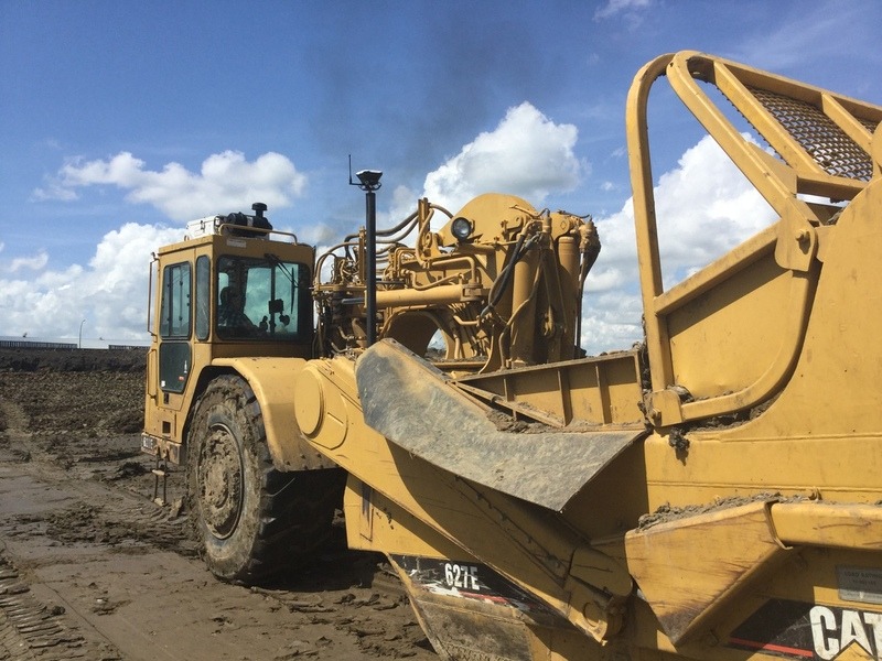
Our community user David Hofer shared on Emlid forum how he uses Reach RS+ and Reach RS2 for centimeter-precise land leveling.
David equipped his wheel tractor-scraper with a Reach RS+, mounted on a damping platform. The platform reduces tough vibrations and bumps and allows holding a fixed solution while the machine drives at a high speed.
RS2 is placed on a construction site and acts as a base by providing real-time corrections to the rover. Such a setup provides a centimeter-precise vertical accuracy that is required for David’s land leveling projects.
“Great job Emlid! Reach devices work the same as Trimble or Topcon but times cheaper. We invested only $15,000 for such a setup and it works awesome for that money!”—David Hofer, Farmer from Alberta, Canada.
To get the best grading accuracy, is needed a software designed for this machinery grading and a rotating laser as base and a laser receiver on the machine telling the exact height to the software and only use the x and y rtk coordinates for the location of the machine to request the required elevation for that coordinate
Hmmm, that would only work for a very limited height difference.
If you really don’t trust the height of a GNSS solution, a robotic total station and 360 deg prism would the answer.
That said, a fixed gnss solution should give you a height with precision less than the machine (ie scraper) is able to “resolve”.
Topcon mmGPS has a transmission range of 120ft vertical and 3000ft horizontal in our experience. This is far below their “spec”, but more than we would ever use. Especially considering that situation that require mm are usually long flat runs… and I think you meant that the GNSS solutions would be more accurate than the machine could ever come close to.
how can you have cm accuracy when the vertical accuracy of RS+ is 1.4cm? That 1.4cm is on a good day with clear skies I would presume. So a moving rover on a damping base with all sorts of vibration and engine shocks would get you cm accuracy? By cm you do mean 10mm or less right?
Our general tolerance in construction is +/- 0.10ft (3cm) and that is easily accomplished on general excavation work. Grade gets dialed in as you get closer to paving and building structures. Hard items typcially are in the 1-2cm range. That shows how tight the control network must be and why we still run level loops on the primary control.
Just revisiting this topic about elevation stake out , now that we got line work in Flow it would be a nice and simpler feature to just have a feature where you could stake the elevation of the line or a recorded point . When the scraper operater is in the stake out screen all he really needs to see is the cut and fill page , not so much the location of the line or point, so it less confusing to him. Thought I would add this to the requests . Thanks