Precise Point Positioning (PPP) is widely used across industries. PPP allows determining the absolute and very accurate coordinates of a particular point on Earth without real-time corrections or base station nearby.
In practice, PPP is usually used for many tasks, where absolute accuracy in data is a priority. In most of the cases, PPP is used to determine the coordinates of the base for further absolutely accurate data collection in both RTK and PPK modes.
PPP is performed using one receiver and a tripod. Although it requires more time to record the data compared to PPK, PPP is now one of the most accurate ways to determine a global georeferencing position.
We gathered all the required information about PPP in one place: the workflow, the setup, the overview of the PPP services, and the ways to submit the data to those services. Check out the detailed guide for Precise Point Positioning by Emlid.
For clarification, in the first part is says GPS-only and then later down it says additionally GLONASS for NRCAN? This would require turning on both initially right?
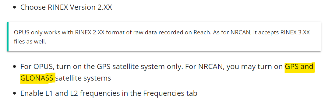
At the moment, OPUS accepts GPS data only, while NRCAN works with both GPS and GLONASS.
While logging, you can enable them both. In that case, the RINEX file recorded on Reach can be pushed to NRCAN directly. However, if you want to process this file with OPUS too, you need to convert the UBX data in RTKCONV so that the .obs file you’ll submit to OPUS contains the GPS observations only.
I have seen on a few occasions where OPUS has been referred to as a PPP system but it always confused me. OPUS doesn’t have a pure PPP product option from what i can tell. for it to work you have to be within range of the CORS network. am i wrong does it work outside the network? it must since you folks are in Russia right?
with PPP you are applying ephemerides (FINAL, RAPID or ULTRA-RAPID) from IGS, in the case of your tutorial, IGS products through NRCAN i believe. hence why its a globally relevant solution source. OPUS applies the same data products, but only (as far as i know) as a additional correction on top of the correction process against the CORS stations.
Is anyone aware of a way to get from the NAD83 (CSRS) to NAD83 (US State Plane 1986)? PPP with NRCAN seems to be way more forgiving/easy to use than OPUS.
Thanks for pointing this out! You’re right about it.
We’ve added both OPUS and NRCAN to one guide as the process of working with them is quite similar from the user’s side. However, we will separate the guides and make it clearer that they are not the same.
For the NRCAN PPP service, there is no maximum baseline. It is a global service and doesn’t work with a base station. Just plop the receiver somewhere, wait a relatively long time over the point, then send the observation file for processing. Very seamless.
NGS OPUS uses the surrounding CORS as reference (think of bases logging data) and your file (rover). It PP the rover using surrounding CORS data. NGS uses PAGES software in determining the rover position. You can download the software, buts it’s very complicated to use. You use to be able to attend seminars in instructions to use. Most state geodetic agencies use to do this.
PPP uses satellite ephemerides to PP the rover position. No CORS are involved in this method.
PP existing CORS against one another is a good sanity check when using new PP software. This is how I learned to use TGO and GNSS Solutions originally. Javad Justin and CHCNAV CG02 PP software are my recent conquests. I don’t use every day, but when I get free time I try to keep learning on both.
I’d like to start using RTKLIB again (it’s been years), but it’s hard to find time running a business and trying to get work out. I wish there was 3 of me !
Hi everyone,
To those that may be interested, the RinexLab (https://rinexlab.com) has a PPP service that processes the four constellations. It can also be processed through an API REST for automation purposes. It works well with the Reach RS2.
TrimbleRTX PPP online post processing is the most accurate of all 6 online service we have tested so far so it would be great to have RS2/RV3 to send directly a RINEX3 static file to TrimbleRTX