Not sure if this will help.
The above linke,dos it show satelites Reach use?
Share links if you got any ![]()
http://science.nasa.gov/iSat/?group=SMD
And another great sat planner. This one is my favourite
http://satpredictor2.deere.com/homePost
Not sure if this will help.
The above linke,dos it show satelites Reach use?
Share links if you got any ![]()
http://science.nasa.gov/iSat/?group=SMD
And another great sat planner. This one is my favourite
http://satpredictor2.deere.com/homePost
web app:
http://www.taroz.net/GNSS-Radar.html
source code on github:
Anybody notice difference from time to time, getting fix?
Ex.getting av fix one day and some time later at at same point, no fix?
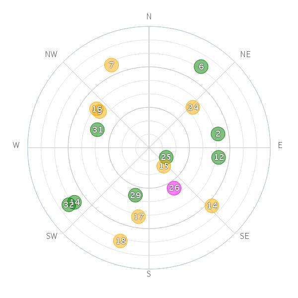
Here`s screenshot from my current position.Any comments on this info?
I choose gps, galileo and glonass, i assume reach process and can use all these sats?
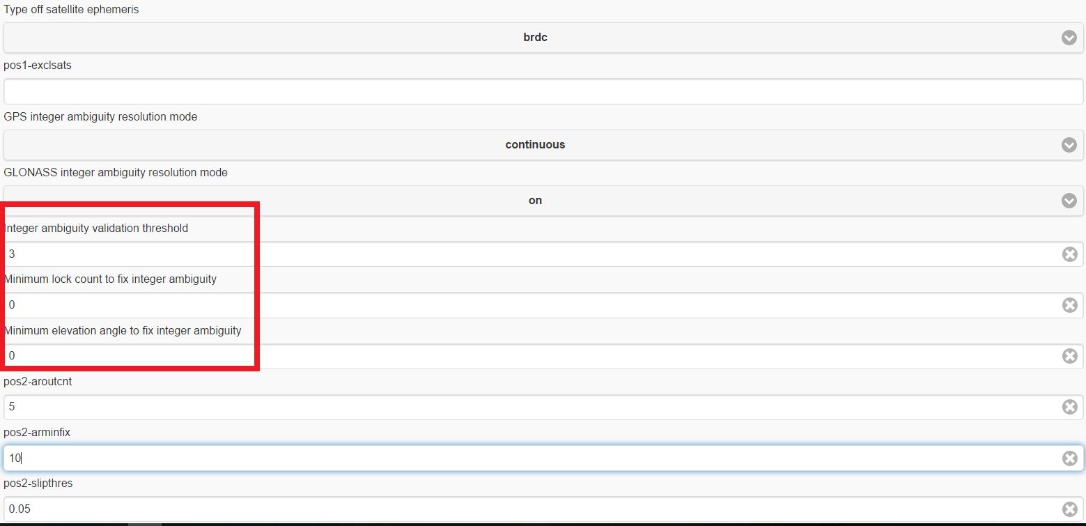
I was told to turn off the integer ambiguity resolution for GLONASS, and I assume that advice still stands. I know there was some talk of a new “fix and bump” mode for GLONASS ambiguity resolution, but I’m not sure if/when it might be implemented.
You can turn off the AR for GLONASS under advanced settings ReachView’s rover mode. For post-processing, you can do the same in the options menu of RTKPOST.exe
Also, if you have 5 GPS satellites showing, try with GPS only. If you get a fix, then add GLONASS and see what happens.
Great tip. I`ll for sure test this .
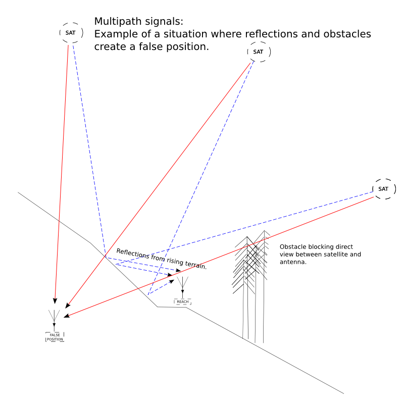
Yes, when logging over a long period of time, I see the fix coming and going, but it usually happens when the antenna is not in an ideal place (like rising terrain blocking part of the sky). With good sky view the fix stays the whole time (many many hours).
All right  I see the level of degrees is set to 10 or 15 as default. Right here where i am testing i have obstacles and measured this to be up to 22 degrees. Should i switch place og try adjusting setting? . I got fix couple of times when moving around in a small spot so i think i am pretty close.
Yes i know about sats and what to expect. I`m just trying to find the minimum or worst condition so i know what to expect when doing live survey, so i dont wast time in an area where there is no hope.
Please share any experience.
I would also like some advice on settings to improve my reception. I have upgraded my antennas and can get 6 to 8 satellites consistently over 45, but very rarely get a fix. I am working in open areas with no obstacles. The equipment that I am connecting to requires a DGPS signal although I don’t really need acuracy better than 15cm. What might be the effect of changing the ambiguity resolution, or the degrees under “advanced”? Or any other setting? BTW I only have access to GPS L1.
@TB_RTK In your skyplot picture above, you have 5 gps satellites which are more than 30 degrees above the horizon. You could raise your elevation mask to something between 22 and 30. Depending on the situation, that may eliminate some multipath signals and get you a fix.
Having a multi-frequency system, (L1/L2/L5, etc.) would help eliminate some of these problems, but they will also empty your wallet of many times more money than Reach does. Instead, it is better to spend time in getting experienced with RTKLIB and save money.
Good point. Recap to see if i got things right.
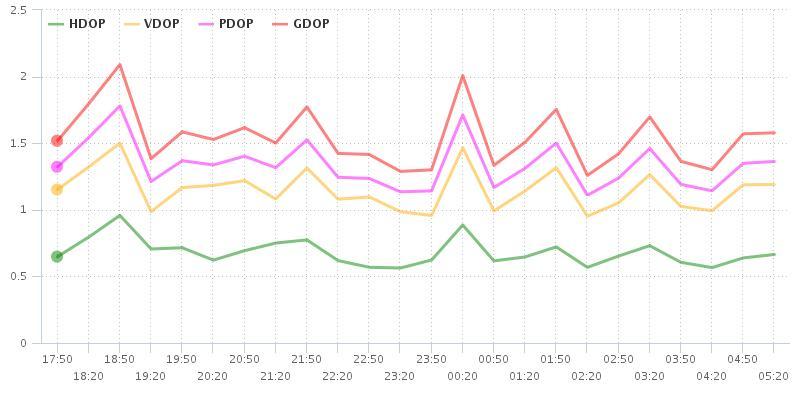
Adjust lvl to 30 to reduce multipath which gives more accurate fix, but loses some accuracy by adding more values to DOP but this is a compromise. Multipath can give large deviation in fix and high DOP gives more inaccurat reading but fixes are closer together. So it all depends on the situasjon and what level of accuracy you need. Right?
Sounds right to me!
We can use Galileo?
You can read about the settings in the manual (in the docs folder in RTKLIB) or find the .pdf on GitHub here.
Not entirely sure, but I think the third one only applies for Fix-and-Hold mode?