


Hi everyone!
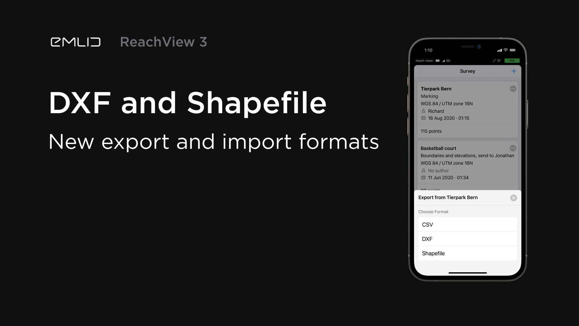
We are excited to announce the long-awaited feature in ReachView 3! Now the app supports DXF and Shapefile formats. You can choose both formats when exporting or importing your projects and easily work with CAD and GIS programs.
23 Likes
This is great and an important update too. Very nice 
8 Likes
I hope you realize how big of a deal DXF is. Now if we can get Engineers to put the CAD in the right place…
9 Likes
You know that will NEVER happen. ; ) Therefore localization.
2 Likes
This is super great new. For current support of CAD file, it could be used for Stakeout or not yet? or just for background map?
1 Like
does this include lines?
6 Likes
Yes, this will be interesting to try out when I get some time this weekend. Wondering also if it will be only a background map or will you be able to stake to points and lines that you select in the dxf file.
I’m a user of the FieldGenius Android version and I like what it can all do, COGO features and all. Just wished it was more stable and not crash as much. I have lessen the crashing somewhat, by disconnecting it from the Emlid receiver through the app, when in between shooting points or staking. Especially seems to help when staking out with the app. Bothersome, but not as time consuming as having to restart the app after a crash, or worse losing your work and not being able to recover the work.
3 Likes
Probably just background but still so helpful. FG Android just released DXF linework as well.
2 Likes
Just tested, it imports only Points from CAD and shapefiles. It is a good start anyway for support of CAD and Shapefiles.
Hope to see improvement on Stakeout out interface like Surpad app.
3 Likes
Hey everyone,
Thanks for the feedback! It’s always a bit unnerving when anticipating the reaction to such a long-awaited feature 
Indeed, we support only the points for now. For now being the main thing here  There is a lot going on behind the scenes in this direction!
10 Likes
Still this means that the points maps that my team creates can be directly imported instead of exported to a CSV, verified and then imported. Just one less file to keep updated is great, especially when the average project can have 5,000 points. Our plan is to create separate jobs for the different scopes such as excavation, utilities, concrete and buildings.
3 Likes
Great news
2 Likes
Unfortunately no…
This is great news and will certainly simplify my work process. Thanks to the development team.
1 Like
This is great, been waiting for it for a while now. I hope the dxf & shapefile importations will soon include polylines & polygons!!
Also, still waiting to see a more functional stake out interface as mentioned in an earlier post in this thread.
4 Likes
Can’t tell for now. But we’re working on the Stake Out screen so we hope to improve it! That’s why your feedback on it is always welcome 
5 Likes
Everyone,
Thanks for the response! Your support means the world 
4 Likes
LINES! We need LINES! 
6 Likes
We’re working on it for sure! Still, this is a complex functionality, so the research takes time.
5 Likes