I’ve tried all kinds of formats with and without headers for my GCP file. Coordinate systems match with Emlid Flow 360… but no luck. Grateful if someone could chime in.
Thanks in advance.
I’ve tried all kinds of formats with and without headers for my GCP file. Coordinate systems match with Emlid Flow 360… but no luck. Grateful if someone could chime in.
Thanks in advance.
I’m having a terrible time getting a .csv file from Emlid Flow 360 in any format into Emlid Studio for stop and go processing. Help! Thanks in advance.
Hi @petehernandez,
Could you please share your CSV file? I’d like to check it in more detail to investigate why it doesn’t work in Emlid Studio. If it’s more convenient, feel free to email it to support@emlid.com. Thanks!
This may or may not be your issue but below Is what I figured out when I ran into that problem a few months back when trying to get a csv to import into Flow.:
That also confused me when I first started using Emlid Flow. Just remember that the "CSV (PENZD)" import option doesn’t use headers on the columns and won’t import the file if there is header information
In contrast, the plain “CSV” import option does require header information (e.g, the words “PointNum”, “Easting”, “Northing”, “Elev”, “Desc”). and will not import if there is no header row. Header on the first line is required.
Also, be careful with your descriptions in the “CSV (PENZD)” option since there are only a few characters that are allowed (letters, numbers, spaces and dashes). That bites me occasionally since I like to use the character “_” a lot which is not allowed.
Just emailed it to support@emlid.com. Thank you.
Hi @petehernandez,
I received your CSV file. Thank you for sharing it!
As I see, it was exported with the PENZD option from Emlid Flow 360. However, the Stop&Go workflow needs the regular CSV format, as Emlid Studio will use the points’ collection time as well.
Could you please check if you experience the same using the regular CSV? Please make sure that All columns is selected under File configuration when exporting your project. Thanks!
Thanks for the reply. I do get Emlid Studio to work if all columns are in the csv file. Then I would lose the northing, easting and elevation columns in the corrected one. I figured out that by reimporting the .csv back into a new project in Emlid Flow, then exporting it again, I could get the northing and easting back but the altitude gets changed to ellisoidal instead of feet. That is my current problem now.
Hi @petehernandez,
Emlid Studio provides the results in geographic coordinates, so the Easting, Northing and Elevation columns will indeed be empty. However, these values will be calculated automatically after importing them into a new project with the same local coordinate system and vertical datum.
I checked this workflow regarding the survey unit. If I created the new project in feet, it was kept after the export, and the altitude was still in feet. Do I understand correctly that, for you, it was changed after the export?
For those PPK’ing your GCPs with “Stop n Go” in Emlid Studio, what is your workflow once Emlid Studio gives the corrected .csv? The Easting, Northing and Elevation columns are empty and the only elevation is in ellipsoidal heights. It’s a bear trying to get a workaround to get that back in easting, northing and orthometric elevation in feet. How are ya’ll dealing with this?
Thanks in advance for any insights.
THank you for that. I tried it and did get the northing and easting back but the elevations are way off. I did use the same coordinate systems as my base.
Prob ellipsoid versus orthometric.
Yes, I would need othrometric converted to feet.
You mean orthometric to ellipsiid height or vice Versa? Both orthometric elevations and ellipsoid heights can be in meters, feet, or US survey feet. The difference is whether your vertical datum is referenced to the ellipsoid or to mean sea level, factoring in the geoid. It’s simple to convert and most survey software applications do this seamlessly.
Thank you. I’ll see if Pix4Dmatic can convert ellipsoidal height back to the original orthometric height in feet.
Maybe when I created a new project I overlooked the unit type and forgot to put it in feet. I know in the field creating a project defaults to meters. I’ll check. Thanks.
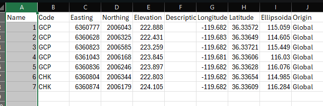
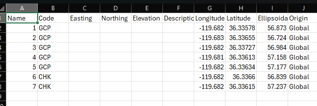
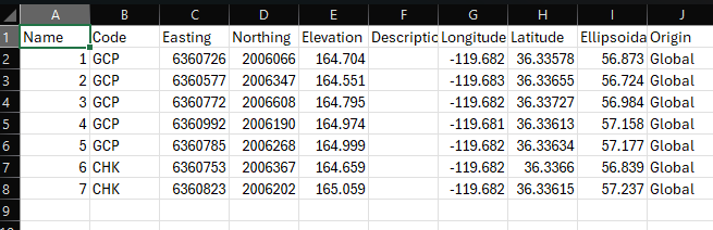
Hello, I’m still having a problem with **Stop 'n Go PPK in Emlid Studio. It deletes the ENZ columns but I fed it back into a new Emlid Flow 360 project with the same settings and get back the E,N columns but the elevation is different. Don’t know what to do about it and thinking about skipping it all together trusting the RS3 is 10 sec. averaging my GCPs well. Check out the screen captures.
Any help to get the elevation to be the same (but corrected) as the original elevation would be great. Thanks in advance.
Hi @petehernandez,
I saw you have been in contact with us over this new thread I answered you there to keep the information all in one place.
This topic was automatically closed 100 days after the last reply. New replies are no longer allowed.