


Hello all does anyone have a solution for this, I’ve tried importing a point from a project to base settings in the coordinate system that i need (StatePlane5) but no luck. thanks for any help.
Hi @chavezindalecio,
Welcome to the community!
Emlid Studio outputs geographic coordinates. To obtain projected coordinates, please follow the steps outlined in this support tip.
You can also share the corrected CSV here or send it to us via support@email.com, and I’d be glad to give you a walkthrough!
2 Likes
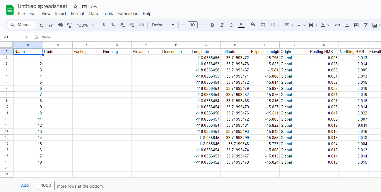
Thank you for the prompt response, i gave that a try and i now have northing and easing in my corrected csv file. A few more questions.
What geographic coordinates system is my base using?
Also, would i be able to project them to state plane in ArcMap? as another option.
to clarify, for the uncorrected CSV, is the lat long always in geographic coordinates? And the Northing Easting always in project coordinates?
Bump^
Hi @chavezindalecio,
Where did you get the base data from?
Also, would i be able to project them to state plane in ArcMap?
I believe this is possible in ArcMap. You can transform the points to your desired projection.
for the uncorrected CSV, is the lat long always in geographic coordinates? And the Northing Easting always in project coordinates?
Yes, you are right. Geographic coordinate systems are three-dimensional grids that define where points are located on the Earth’s surface, expressed in latitude and longitude.
Meanwhile, the projected coordinate system projects these points onto a flat surface, like a map, expressed in northing and easting.
I am using a RS2 for my base and a RS2+ for a rover. The goal is to use the RS2 to correct a wingtra gen 2. The wingtra ppk software accepted the rinex file from the RS2 but im confused with the coordinate systems.
To add to this, my control points are now in state plane 5 with the workflow mentioned above. But whats my ortho going to be in?
What I have found lately is that ES still outputs Stop&Go corrected CSVs without projected coordinates even if the original CSV file had them (working in RTK but correcting base with PPP afterwards). We had projects where averaging for survey points was turned off and every one of those points are corrected without E/N/U and their corresponding RMS values.
Changing the averaging to 1s while collecting, the problem disappeared and even manually changing the recording end value to 0.1s later than start time in the CSV also makes ES output projected coordinates.
I remember reading about this issue some time ago but I don’t know if it was ruled as a bug or working as intended.
1 Like
Hi @chavezindalecio,
I haven’t tried Wingtrahub, so pardon my ignorance. Is there a way to specify the coordinate system in Wingtrahub? The results in Emlid Studio are always in Global CS and depend on the datum of the base.
Hi @Gabriel_C,
The results in Emlid Studio are always in geographic coordinates. You must transform them via Emlid Flow or 3rd party software to obtain projected coordinates.
We had projects where averaging for survey points was turned off and every one of those points are corrected without E/N/U and their corresponding RMS values
When the points are collected instantly, Emlid Studio will return an error. The points collected should be averaged to post-process the CSV in Stop&Go.
Hi Ruth,
Here is a snip of my coordinate system options in Wingtrahub.
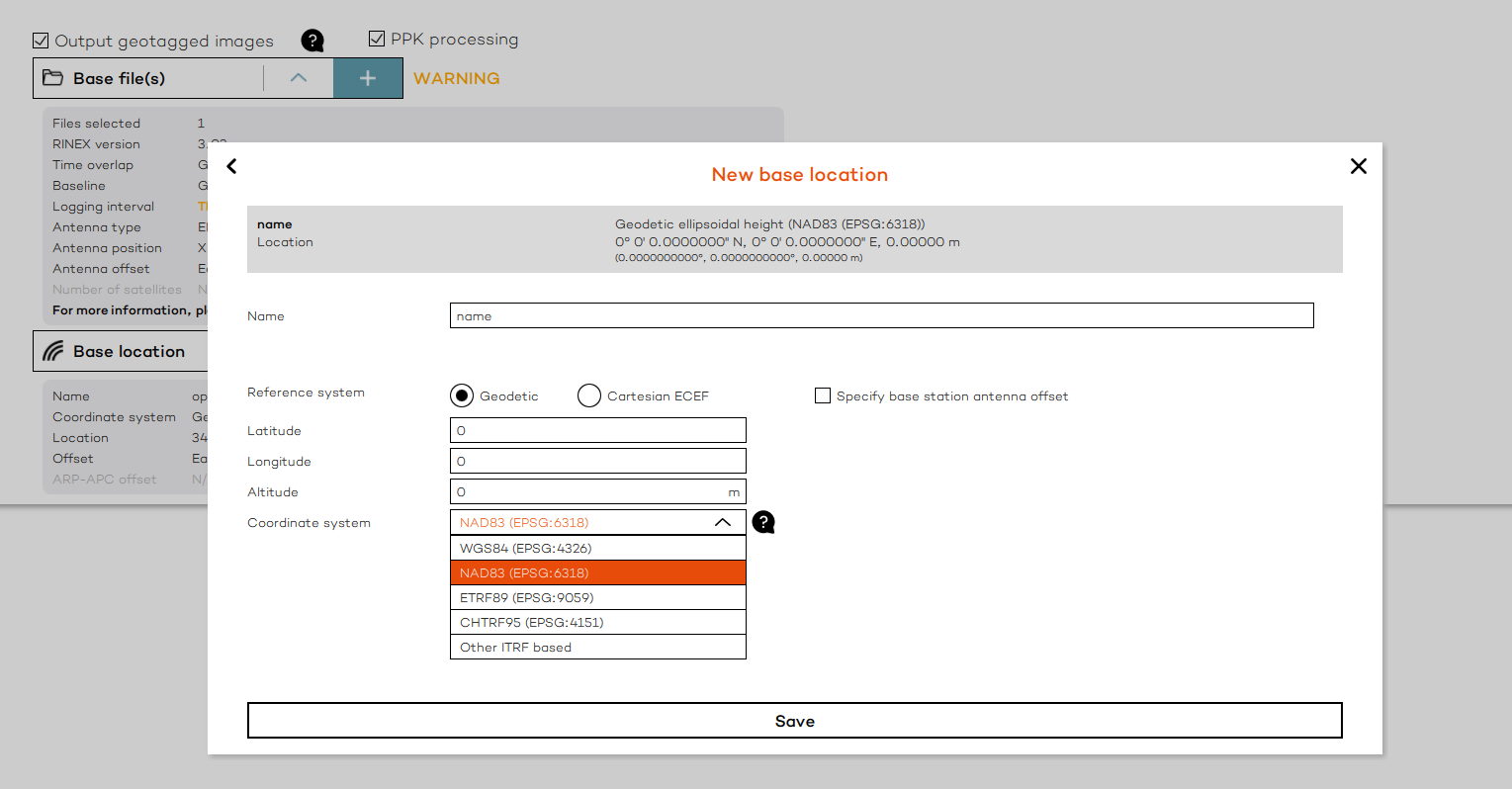
Where can i see the “datum of the base”? I imported the single point that was using NAD83 SP but i don’t see anything on the base settings the specify what CS its using.
Again, thank you for your help with this.
Thank you Gabriel, I’ll give this a try next time. The Import export method Ruth mentioned above worked but I want to eliminate any error if possible.
I was actually mistaken, Ruth is right, E/N/U disappears when we reprocess with Stop&Go. I was mixed up because we were mixing RTK and PPK in our project.
1 Like
Hi @chavezindalecio,
Will you use one of the points from the corrected CSV as the base coordinates? If so, could you please give me a walkthrough on how you post-process your data with Stop and Go in Emlid Studio?
You can also send an email to us support@emlid.com if it’s more convenient for you. Thanks!
Hi ruth.bongon
i cant use one of the points form the corrected CSV. Those points are from my rover.
Emlid Studio
- I upload the rover Rinex file to rover tab
- Base Rinex to the base tab
- Rinex file was sent to opus and im plugging in the nad83 GCS Meters
coordinates to the lat long option under base on emlid studio. - I set the navigation file to the same base.
- Then generate my corrected csv.
- I do the workflow you mentioned above to get me to get me in to nad83 SP5.
Wingtrahub
- Process the PPK with emlid base Rinex file and use the opus nad83 GCS Meters
coordinates get 100% fix
Pix4d
- Process my ortho in nad83 GCS Meters
- Bring both my ortho and corrected points into ArcMap and check GCPs and im one meter away.
Same question, is there a way to verify that my base in set up in GCS nad38 (6318)?
Hi @chavezindalecio,
The workflow seems correct. I’m curious, though. Why didn’t you use the corrected CSV as ground control and checkpoints during the photogrammetric processing? Even with PPK and RTK drone surveys, you’d still need at least 1 or 2 ground control points. In a metaphorical sense, these GCPs will pin your model onto the ground.
Thank you Ruth. Wingtra, has a hi accuracy claim in there PPK system, and only recommends checkpoints. I have some intuition that something is off with he coordinate system. because all my GCPs are falling close to the meter mark away all in the same direction.
Say i wanted to switch my workflow to WGS 84 (4326)
When starting a rover project in Nad83 state plane 5 are the lat long coordinates collected, a on the fly conversion of what the state plane coordinates would be? or are they wgs 84 lat long coordinates?
I if i understand correctly the Northing Easting are already projected.
I i convert my st5 N E to WGS 84 will i arrive at the same coordinate listed in my lat long?
The corrected coordinates are in NAD83(2011). If you need the coordinates of the rover points in WGS84, you should use the ITRF-based coordinates provided by OPUS as the base coordinates in Emlid Studio.
This might take time, but I suggest testing the workflow using at least 1 point for ground control and manually marking them on the images in your photogrammetry software.
I’m going to try the same workflow in WGS and report back. Again, thanks for your time!
1 Like