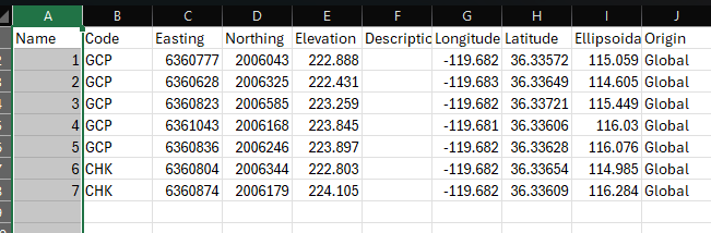
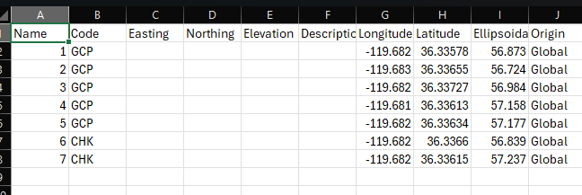
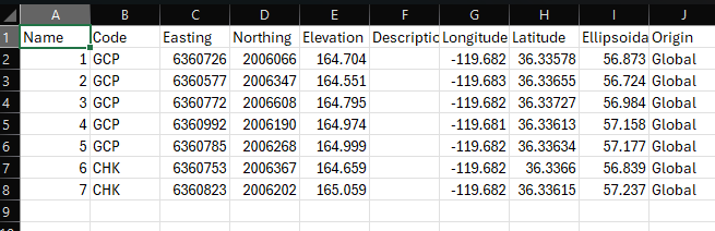
Hello, I’m still having a problem with Stop 'n Go PPK in Emlid Studio. It deletes the ENZ columns but I fed it back into a new Emlid Flow 360 project with the same settings and get back the E,N columns but the elevation is different. Don’t know what to do about it and thinking about skipping it all together trusting the RS3 is 10 sec. averaging my GCPs well. Check out the screen captures.
Any help to get the elevation to be the same (but corrected) as the original elevation would be great. Thanks in advance.
The elevation issue might be caused by a mismatch in vertical datums between your Emlid Flow project and your reference data.
Could you let me know the coordinate system you’re using for your project and how you’re collecting the GCPs in Emlid Flow? Also, please export the project to a CSV file and send it over—I’d like to take a closer look. You can share directly here or send to our support email address: suport@emlid.com.
If I understand correctly, you compared your elevation from the Reach using stop-and-go with the OPUS result and saw discrepancies in the elevation. Do you still have the issue with elevation? Do you correct your base with an accurate position when processing in Emlid Studio?
Could you share more about the Pix4DMatic workflow? Did you compare it with point processing here?
The problem is resolved. Though the orthometric height in feet has been changed to ellipsoidal height in meters. I can convert myself. It was resolved when I created a new known point with OPUS. Thank you for following up.