I already connect my rover through Bluetooth, and created a profile for emlid caster to get mount points then when to correction input over BT created the profile and filled all of the credentials. On emlid caster it says My Rovers online 1/10 but it still shows “Waiting for FIX.”
If I got you right, you’re trying to get the corrections from Emlid NTRIP Caster to the Reach RS3. If so, then it’s not going to work this way since our Caster isn’t an NTRIP service that provides correction. Emlid Caster can be used as a tool for transmitting the corrections from your base to your rover over NTRIP. Here’s the article that covers this topic in more detail.
Now when it comes to getting a NTRIP service and knowing your Coordinate System in my case I’m located in El Paso, Texas United States which service would you recommend or a website would help.
Thanks again.
Hi Michael, I use the Hexagon HxGN SmartNet (Leica) service here in Texas and purchased a Texas State wide year subscription paid in advance. You can find out more here at this Link: HxGN SmartNet | HxGN SmartNet
They offer Single Base (MSM_Near) and Network Multiple Base VRS (MSM_VRS) type service that you can choose from for the Mount Points. It is broadcast in NAD83(NA2011) (MYCS2) Reference Frame and the Epoch is 2010.00
There is also other service providers in Texas.
One is https://www.rockrobotic.com/rock-base
You can either purchase a Base unit and installed it at your home/office and gain access to their network that way or you can just purchase access for $40.00 a month + tax. It would be a Single Base type service, so you have to be within about 35k of a Base Station. I would like to take advantage of it, but they don’t offer service everywhere I would need it.
Yeah I wished. As far as I understand, taxpayers helped pay for the equipment located mostly at the Texas Department of Transportation locations, but we can’t access the correction service unless you are on one of their projects. I pay $1,450.00 with tax a year with the SmartNet option. Great service but not cheap. Cheaper than the $2,000.00 a year with AllTerra RTK Network - RTKnet option, though they cover 4 states. I can’t always deploy a Base unit like I would like to because of the theft problem. I envy the states with low cost or free access!
SC is not free, it’s $600/year but very affordable. As taxpayers to any city, county, state or federal mafia we own all equipment, offices and any other material objects that are purchased by the mafia.
I for one despise paying any tax, however law enforcement, first responders and fire departments are necessary. Even some basic forms of government overseeing.
I feel fortunate to be able to pay for a state wide correction service, to have access to the base files of the states RTN and also the national CORS
Thank you I got it to work! I’m using Point One Navigation
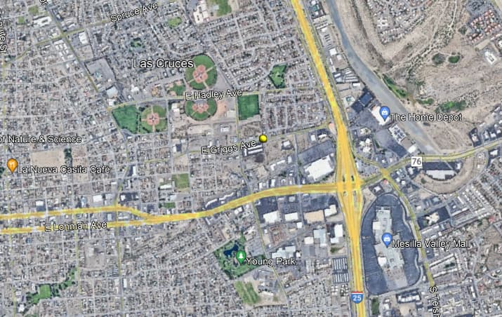
Now the problem that I have is finding why the coordinates that the city gave me are not were they suppose to be.
For example,
Easting = 1484494.389
Northing = 479078.291
Elevation = 4060.06
When I add this point is puts it in the ocean south-left side of Mexico, not in Las Cruces, NM where it is suppose to be. It’s way off I know Im doing something wrong.
Hi Michael, the coordinate that you posted seems like it is correct for Las Cruces, NM. area.
In Earthpoint, using US Survey ft, (https://www.earthpoint.us/StatePlane.aspx) I used the following Zone: Zone 3002 - New Mexico Central
Meters US Survey Feet International Feet X 452474.795 1484494.389 1484497.358 Y 146023.355 479078.291 479079.249
Calculated Values - based on Degrees Lat Long to seven decimal places. Position Type State Plane - New Mexico Central Degrees Lat Long 32.3160615°, -106.7547353° Degrees Minutes 32°18.96369’, -106°45.28412’ Degrees Minutes Seconds 32°18’57.8215", -106°45’17.0471" State Plane X Y (Meters) 3002 452474.795mE 146023.355mN X Y (US Survey Feet) 3002 1484494.389UsFtE 479078.291UsFtN X Y (International Feet) 3002 1484497.358ftE 479079.249ftN
It also can produce a kml file for Google Earth and that shows Las Cruces, NM