


To receive the exact result through EUREF, only your session of a dozen or so minutes is enough.
This is best shown by an example. Send such a session, preferably raw data (* .ubx), plus info in what coordinate system you want the result.
Do i understand this correct, you can send raw log to euref and they will send you the result?
1 Like
No, not like that. I will show you how to calculate it (this example of Christian Gruner) using free of charge EPN (EUREF European Reference Network) and legacy software (also free of charge for L1).
1 Like
These are basically EUREF (GREF) data, free of charge, with free of charge software, Emlid RTKpost ?
Maybe I am misunderstanding your statement?
It is difficult to explain with generalities. Just attach your session (about 20 minutes, interval 1 second) and on this example I will explain how to calculate it very precisely. It does not have to be a specific point but something in this area.
Here is one .ubx from a known position you can try. WGS84 or UTM32
then maybe give RINEX, or start and end time:confused:
Converted .ubx files
Does it work now?
Yes, thanks.
looking forward to seeing the results 
The results are in reports. For the RS (Rapid Static) method, a 15-minute session is enough. WGS84 and NTM05. At UTM32 it will take some time.
Land Survey Overview1.pdf (129.7 KB)
Land Survey Overview3.pdf (186.6 KB)
What software is that and where can I find it? You said it was free?
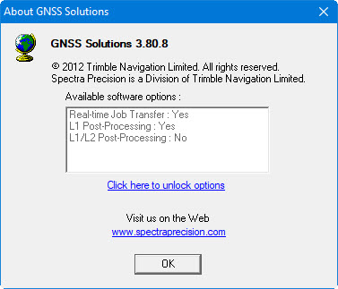
From what I can see, GNSS Solutions isn’t a free product? Can’t find a price, but can’t find a way to download (even for a trial) either?
Here, the thread topic is how to measure when referring to distant stations using a single-frequency receiver (here 143km). I do not advertise any software. But it is difficult to explain anything without specific information on the forum.
Here I show that a short static session is enough for the Reach module, but postprocessing is needed through VRS close to our point. This is a known Rapid Static method.
The self-generation of VRS is a task for professionals. It is better to order where they have such options.
In Poland, for example, ASG-EUPOS (governmental). The cost is 1-2 euros per VRS (3h sessions) (minimum order 70h). This is also not advertising, only information that does not make sense for your own postprocessing.
Let us not deviate from the subject. How does this 15-minute session with geodetic data of this point agree?
Thank you.
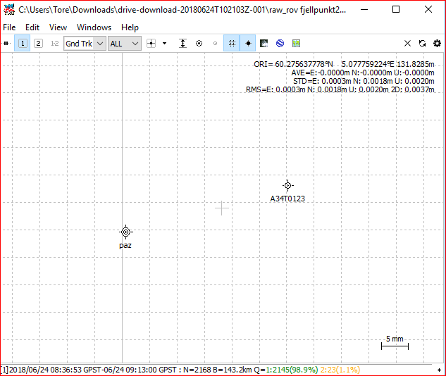
Here is the absolute coordintes for the point named A34T0123
60.275638120 - 5.077759770 WGS84
How far of is it?
But here is the result when i use @r.pazus processed value and compare it to known point.
paz= is processed and A34T0123 is the actual known point. Not shabby at all 
Like the use of VRS to gain better process data.
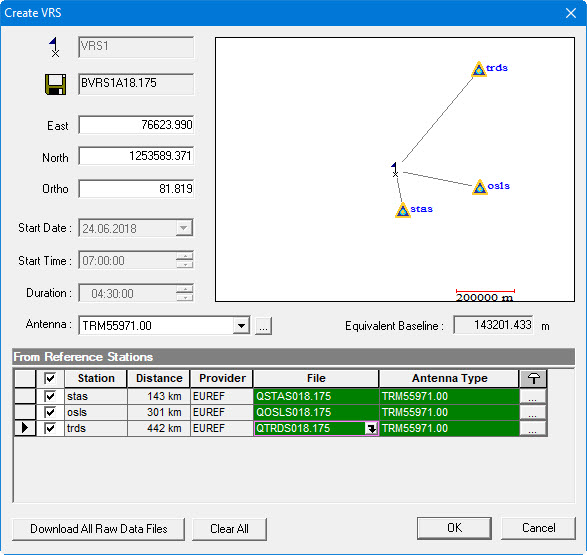
So if I understand this correctly, being a n00b at this, GNSS Solutions uses more than one EUREF base station to create a VRF closer to the point of our raw logs? From that VRF, we can then get a another raw log, that can be for calculation in, say RTKpost, with a much smaller baseline ?
Exactly. A minimum of 3 reference stations are needed to generate VRS. Here in EUREF all were far away: stas (Stavanger) 143km, osls (Oslo) 301km and trds (Trondheim) 442km. This is an unfavorable situation in EUREF for this area of Norway.
This virtual session must be longer to receive such accuracy. EUREF has a disadvantage because the observations at the reference stations are in the interval of 30 seconds.
But our 15-minute Reach measurement is enough to get, as you can see, the high accuracy of the point’s location.
I did not check if there is any VRS generating service in Norway on request.
Included are the RINEX files used for the calculation.
15min.zip (572.2 KB)
vrs1.zip (171.1 KB)
Having VRS, there is no need for sofisticated postprocessing.