


Please share the accuracy results if you can. With adjusted time lag and no GCP, what could be the accuracy compared to your check points?
Ok, so trying to retag the photos as a group with a multi-battery mission is probably not the best idea. It seems to have match from 1st to last well, but images around the transition of batteries was not good. Processing in chunks now.
1 Like
Hi timmyd,
from your pix4d report, the result looked good.
-
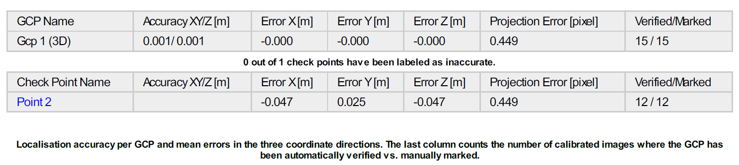
In Pix4D, you can use only one point for GCP? I thought we need at least 3 GCPs.
-
What was the time lag you apply? 300ms?
Thank you for your response.
I was able to complete the post processing on the multi-battery flight and it is processing. I’ll have more results soon.
I believe he used one GCP for placement on the site and not standard GCP processing. I would suggest though that for real accuracy and repeatability that three be used. I’m interested in the offset as well, but I believe a third of a second is way too much unless you were flying a 1mph…
I think it really depends on the job you are doing and the needs of the end user. If I had a job that I was providing for a surveyor, I would still have 3 GCP’s.
Right now my number one project is getting a system down pat for updating the EXIF and XMP data for the images taken on the Phantom 4 Pro with the PPK data from the M+. I was able to download P4P RTK images today from the drone deploy thread that @michaelL is active in and look at the EXIF tags. It will be very slick once I get the process down for updating the P4P images with the necessary Metadata to drop them straight into Pix4D (or DD) with accuracy (standard deviation) values that I get from EZsurv.
1 Like
@michaelL thought maybe you may have an idea on this. The new P4P RTK photos have a section in the EXIF XMP data for the RTK accuracy. Those tags are:
Rtk Flag : 16 (I have no idea what this is for. It seems to always be 16?)
Rtk Std Lon : 2.70368
Rtk Std Lat : 1.53912
Rtk Std Hgt : 3.68277
I need to figure out how to easily take the data from my CSV file which will contain :
Image File Name
Latitude
Longitude
Altitude
The custom tags listed above
I need the EXIF editor to write (update) all the images with this data. It just be overwriting the EXIF GPS data for the Lat/Lon/Alt, but it would be adding the XMP tags for the Accuracy values. I have tried and played with multiple EXIF editors and I can’t seem to find one that will do what I just described. The main program that these all rely on is exiftool.exe. It may do it, but I am not sure how to accomplish it. Let me know if you have any insight.
The only two I have been able to get to do what I wanted as far as sync’ing the new geotags are exiftool and Geosetter. Not a big fan of exif tool after that. I am not familiar with the need for XMP tags so unfortunately I can’t help with that.
EVENTLOG.bin - exposure, time stamp and log file.
PPKRAW.bin - satellite observation data and ephemeris data.
Rinex.obs - you know this
Timestamps.MRK is a ASCII format that stores exposure and time stamp.
I don’t know where you get the equivalent of the base OBS as it seems like most people are having trouble understanding it and many are using networks instead. I’ll let you know if I find something out.
Can u be more specific on the obs question? What kind of problems are they having? Are the problems using RTKLib?
Apparently most people don’t read instructions and are having a hard time configuring. Even worse they expect that it is going to work RTK all the time and without GCPs so they are in for a disappointing surprise. Several people that i have chatted with jumped right in and didn’t even know what PPK was or how to get into that mode.
My problem is that since I have never had one in my hands I don’t know where the base OBS file is stored.
Thanks for the reply. I tried Geosetter but I can not see how to update EXIF data from a CSV file. It seems that it should be so simple to find a program that will take the CSV file (which contains the Image file name) and then update all the images with the EXIF data in the CSV file (provided the TAG names are correct). But so far I have had no luck. I think some folks have written scripts for this kind of stuff in the past but I am not a script writer.
Sooooo, if you can share info on how to update the EXIF data using Geosetter or come across a program that will write/update the EXIF data please let me know.
I will upload a complete EXIF txt file exported from one image on a P4P RTK model.
NOTE: I don’t have a P4P RTK model. I simply downloaded the images from the thread you are on in DD forum so that I could get the EXIF format.
The specific data that we need to inject into the regular P4P images for Pix4D to read the accuracy (and I assume DD) is the four tags:
Rtk Flag : 16
Rtk Std Lon : 0.00000
Rtk Std Lat : 0.00000
Rtk Std Hgt : 0.00000
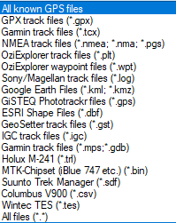
I’m not quite understanding what you are trying to achieve or why you need that extra data. All I am doing is using RTKLIB to end up at a GPX file (from the events POS) and using that file in Geosetter to update the GPS information. These are the file types Geosetter accepts as track files. I don’t know if the CSV they use is a standard CSV or if it has some special “Columbus” header… I assume you can get your CSV into Google Earth. We can also learn to do it through QGIS. 
I verified that you can import a CSV into QGIS and save the data as a GPX… and many other formats.
The plot thickens. I will definitely be looking into this a little further.
https://www.expouav.com/news/latest/geocue-gnss-capability-phantom-4-rtk/
Paying special attention to this part. “Currently, the DJI D-RTK-2 base station (optionally available) for the P4R can only be used in RTK mode and then only if it is being sited on a known location. The D-RTK-2 does not allow access to an observation file.”
So apparently only the drone data can be PPK along with a network OBS file?
Now my head is spinning. If you can put the P4P in PPK mode then why can’t I use my Emlid or Topcon base OBS file and post process the same way that we are now. I’m afraid that it’s going to be really hard to get an answer to that.
Hello chascoadmin,
What did you mean by “5hz is not fast enough for the drone”?
I ended up going the other way; went from 14hz back to 5hz so I could track another constellation. This gave me more fixed track for no measurable drawback
I have my first PPK flight tomorrow with a fixed wing w/ Emlid M. Going to start at 14hz GPS only. Did you go back and conduct the same flight with these parameters, any difference?
I had a much harder time matching consistent time offset so I ended up using the full track instead of the events file. It was hard to tell exactly where to match the point, but they were consistent and proved relative after processing.
I am now running 14hz with GPS, Galileo and SBS and it has been working fine.
I ran this setup again today and missed several events. I don’t know that it has anything to do with the extra sat constellations, but I was still able to match and image to a time and then use the full track.
Hello chascoadmin,
What did you mean by “5hz is not fast enough for the drone”?
I ended up going the other way; went from 14hz back to 5hz so I could track another constellation. This gave me more fixed track for no measurable drawback
I was experiencing cycle slips as was evident in rtkplot. Even going to 10hz was better. @Brian_Christal, my problem now is that the sensor appears to be missing events.