


I’m interested in hiring someone into my company to discuss the process of outfitting either a Phantom 4 Pro or a Yuneec H520 with Emlid GPS components and a PPK workflow. Anyone interested? I have leverage in construction drone operations to create further opportunities.
Hi Michael,
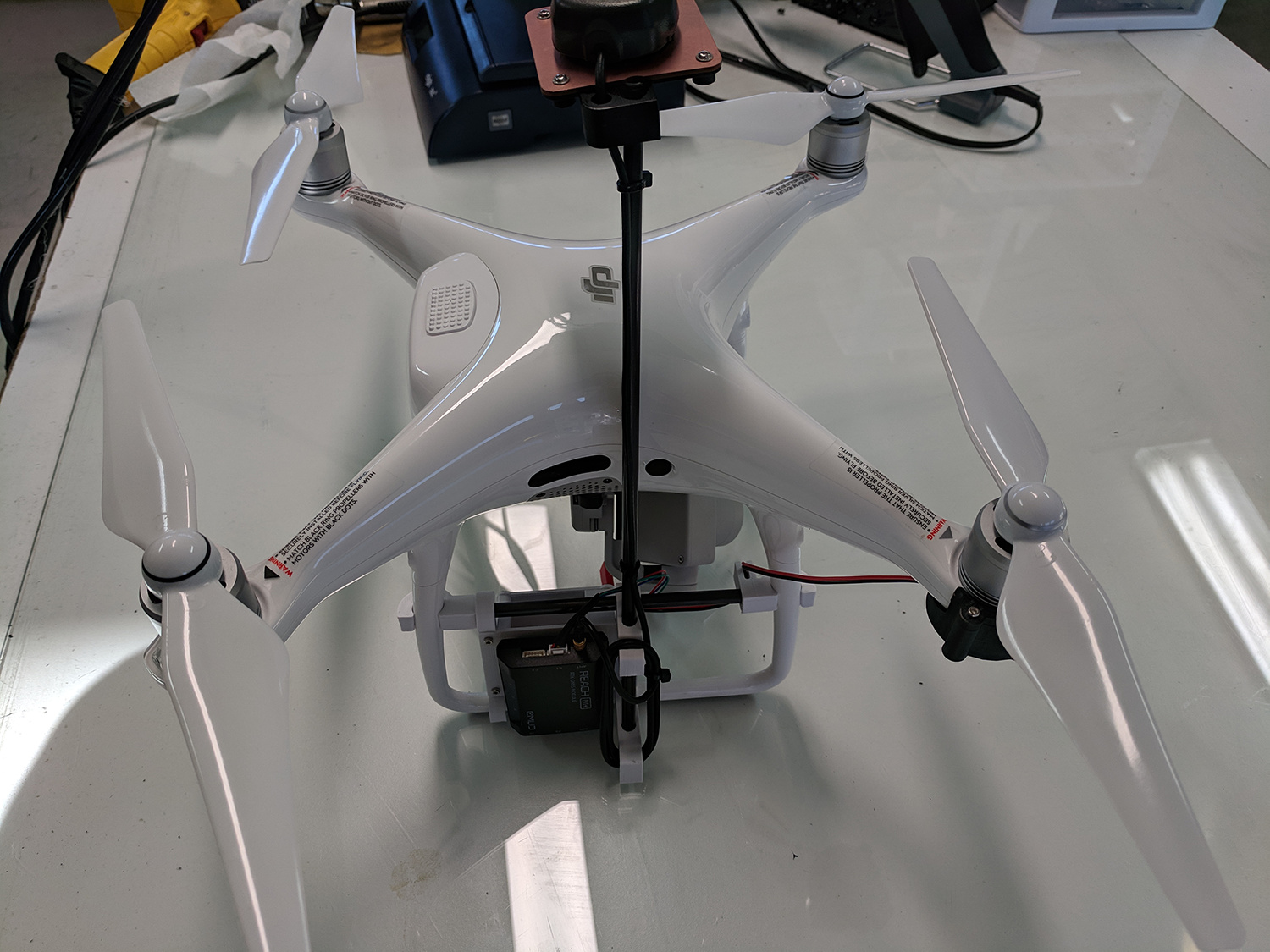
I’m in Texas and have the product you are looking for. I need additional testing. It’s a Reach adapter for Phantom 4 Pro. It snaps on. No drilling or gluing. These will sell for $250 when testing is finished. Let me know if you would like to order today [beta] for $100. The adapter picks up the LED flash when the camera is triggered. We also have a program to offset the picture events due to LED lag. You’ll need a Reach M+ and Tallysman antenna.
Let me know if you’re interested.
-Brian
Tuffwing
830-446-1500
1 Like
Brian,
You can count me in on beta. I originally got a kit but the mounting was not good so I worked on redoing the mounting. I am not a pro designer so there are certainly lots of room for improvement. I am ready to do PPK with my P4P so I would love to jump in!
Tim
Midsouth360
1 Like
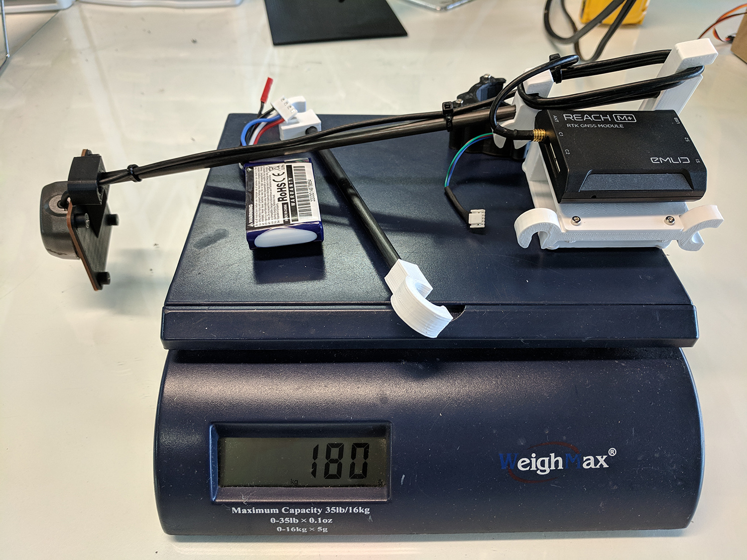
Hello Brian, what does your kit weigh with battery?
i assume it’s powered by external battery?
@Brian_Christal, That’s a well-designed install! I have a spare P4P so I’ll throw a buck at it. What part of Texas?
Hello. I’m in for beta !!!
Hi Michael,
I’m in Boerne. Nice projects on your web site. If you send an email to brian.christal@gmail.com I’ll send back a PayPal invoice.
Thanks!
Brian
Hi wsurvey,
Sorry I’m in the field this week so I don’t have my scale. It is as light as possible. The mast and crossbar are 6mm carbon fiber tube - almost no weight. The tiny ground plane and 3D printed parts are light as well. The weight is the Tallysman antenna, Reach Module and 370mah 3S battery (39g).
Hi Brian
Do you also going to sell the software/program separately?
Hi Bimbodanu,
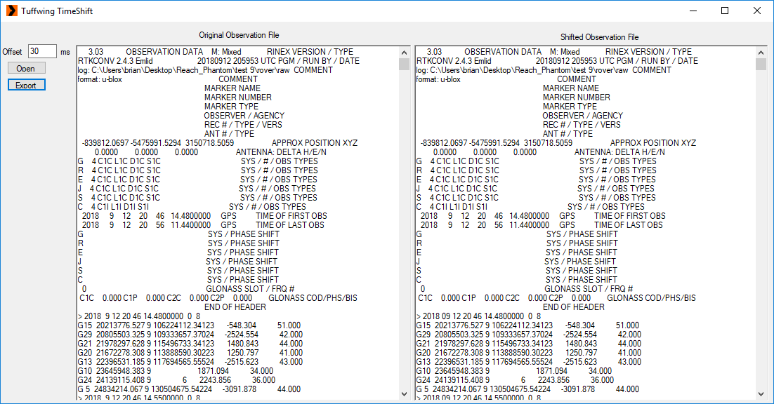
I’m am not the author of the software. The author eventually wants to sell it. For now we’re just trying to verify usefulness and work on new features. Here’s a screenshot of the time shift utility.
- Open an observation file
- Enter time offset in milliseconds
- All time mark events are get time added, then re-inserted in chronological order with the satellite observations.
- Export > filename with time appended.
It works - but much more testing needed to verify what accuracy you can get with time shifted events.
-Brian
Cool, we’ll wait your reach adaptor to the final release
Cheers Brian
Looking forward to testing.
That makes two of us!!
Brian, Is there any way to get a copy of this event-shifting software. Can it handle negative offsets?
I need to work a few things out with the author first.
Yes, It processes negative time. However I did not run the obs file through RTKPOST and compare geotags in Excel or Pix4D.

Hello Mr. Christal,
If you would count me in as well, I have the items you mentioned in the previous message.
Thank you in advance.
Ok, I finally had a little bit of time the past couple of days to go through the documentation I could find for RTKLIB and I understand some of it in terms or traditional surveying, but I also had an opportunity to fly the Tuffwing P4P Reach M+, generated the events.pos file and am now stuck with what to do with my images. Any help would be greatly appreciated. Merry Christmas to you all and your families!
Michael,
Here are the links to Brian’s pages for doing this in RTKLib. I am going to do 2 tut videos this week. One is using EZserve do PPK the drone flights using Brian’s kit and the second will be using RTKlib. Option 1 is way easier but it can be done in both.
I have flown multiple missions now to test Brian’s (Tuffwings) kit and it working like a champ.
http://www.tuffwing.com/support/reach_ppk_tutorial.html
http://www.tuffwing.com/support/Reach_precision_gps_ppk_setup.html#Image_georeferencing
http://www.tuffwing.com/support/reach_geotag_event_hot_shoe_cable.html
http://www.tuffwing.com/support/ReachGPS_Pix4D_sample_data.html
Here is my most recent mission that I flew with 359 images. All 359 were accounted for in the camera events (using M+). I used 1 GCP and 1 checkpoint, and I believe this was 5cm accuracy. Very sweet setup!
Here is the Pix4D report:
2018-12-22 Snowden PPK_report.pdf (1.8 MB)
1 Like