


Awesome, thanks @timmyd. I have run two tests now and it captured my events as well, including the DroneDeploy preflight test shot. Since I usually takeoff from one of my GCPs it may be a good way to get that for the processing if needed. Or at least a checkpoint.
I have chatted with Stephanie, but still need to have the demo.
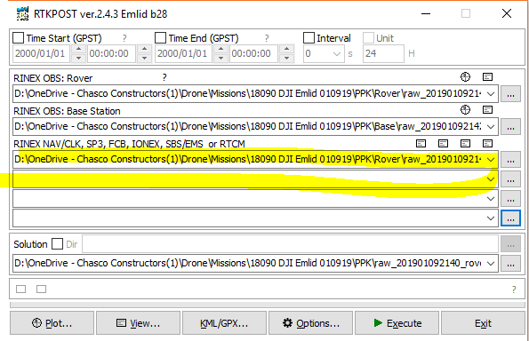
Hi all! I am making my first attempt at using RTKLIB to process my Reach M+ P4P and RS+ data. I am at RTKPOST now and don’t know which, or if both NAV files?
According to Emlid, you should use the rover nav file. However, especially under difficult conditions, I find it helpful to use the mgex .yyp files for this.
1 Like
Got it. I will try both and ground-truth. Thanks @wizprod.
Next thing I need help understanding is the positions tab in options. What do I do when I set my base station up on a known point? I manually entered the coordinates in base mode, but did not run corrections. Do I need the base obs at all? Or can I just manually enter it in positions? The documentation suggest Rinex Header…
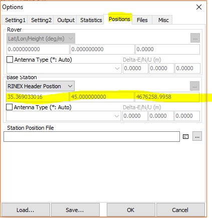
Use the drop-down just over the 3 input-fields, and choose the right option.
That’s what I was assuming, but wanted to make sure. So what does the base obs do if I enter manually?
*Also, I need to enter the rod height somewhere? In antenna underneath?
![]()
1 Like
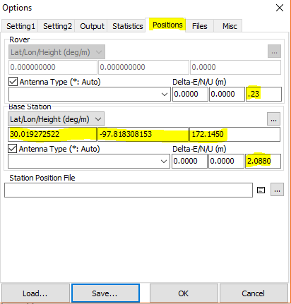
You probably need to put a 0 (zero) in front of (.23)
If RTKpost is that smart i would be surprised 
 , does that make sense to put in from the Tallysman down to the camera center?
Everything seemed to post-process correctly, but I won’t know until I can upgrade the geotags in the images and process the map. I am going to try to use Geosetter. First thing I ran into is that it does not like the Emlid RTKLIB GPX file.
Sorry, on my third beer.(Friday night here). Everything seems to make sense now ![]()
I might edit this post in the morning
1 Like
Enjoy! Thanks for the live assistance! I’ve got two hours left… 
1 Like
But yeah, a positive value would put the antenna above the object you need the correct value for.
Ok, got the GPX file into Geosetter and it doesn’t have time, elevations or airspeed. The POS files do. With the events file there has to be an easier way?
1 Like
So now I see another offset value underneath that. Do I need to put the rover antenna height in there as well?
You dont have to if offsets been applied earlier.
I left that offset alone and am processing the data. I have a case study running and will have processed these images with 6 different methods so the ground-truth and end of this thread are near! Once I am comfortable with this mission and results I will, of course, run subsequent flights to proof the workflow. By the end I should have solid data comparison of the following.
Ground Survey
vs
Drone Surveys
- DJI P4P with single-point calibration
- Emlid P4P M+ (mounted-only) with single-point
- DJI P4P with GCPs
- Emlid P4P M+ PPK with single-point calibration
- Emlid P4P M+ PPK with GCPs