


Hello everyone!
In this post I’d like to share some hands-on experience surveying with a DJI Phantom 4 Pro upgraded with Emlid Reach.
I’ve been using different kinds of drones for aerial surveying – both self-made and commercial. Typically, all of them require additional preparations on the ground in order to achieve centimeter grade accuracy of orthophotos and DEMs. Mainly putting a bunch of ground reference points and getting their coordinates for later use in photogrammetric processing.
But recently I got a Phantom 4 with integrated Emlid Reach from these guys. I gave my preference to this solution cause it is one of the most affordable on the market. Plus, detachable antenna seemed like an advantage to me. You just unplug it when you don’t need it. The drone operates as usual without it.
First thing I decided to check the accuracy of the survey with this PPK drone. A hilly area with height variations about 13 m was used as a test site. Before the flight, 10 ground control points where installed and their coordinates determined. Then a base station was set up in static mode with 1 Hz update.

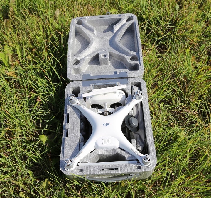
It worth mentioning that upgraded Phantom 4 from UAV-Design fits in its original case, which means hustle free transportation.
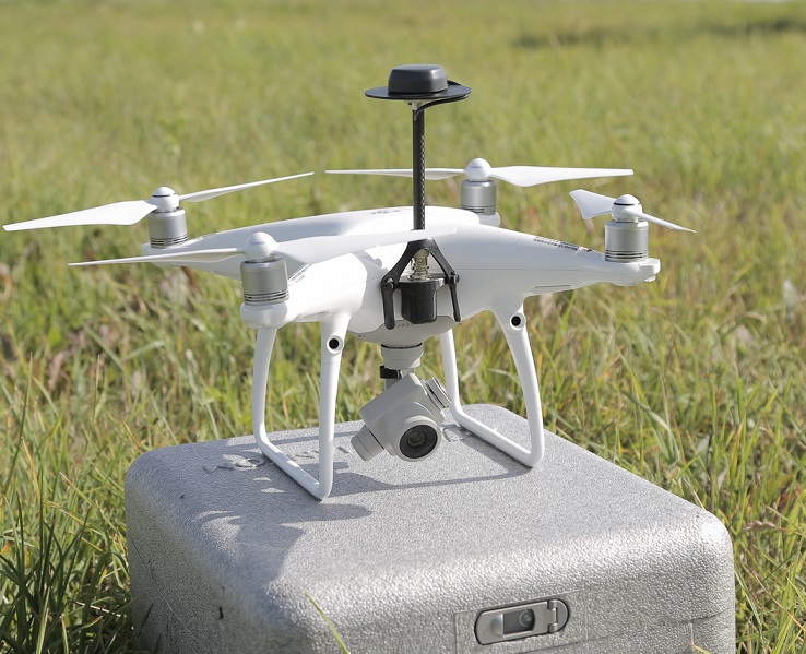
As I mentioned above, the GNSS antenna is detachable and sits separately in the case. There is a connector on the front side of the drone. You just plug the antenna in and fix it in place with two locks. If you just want to shoot some video with your phantom, there is no need to fly with the GNSS antenna, you can easily take it off. On the picture you can see 70mm ground plane.
To cut the long story short, there were 4 flights at the altitude of 68m to 90m. For flight planning I used Pix4Dcapture. Post processing done in RTKLIB and Magnet Tools for comparison. Obtained image center coordinates where fed into Agisoft Photoscan.

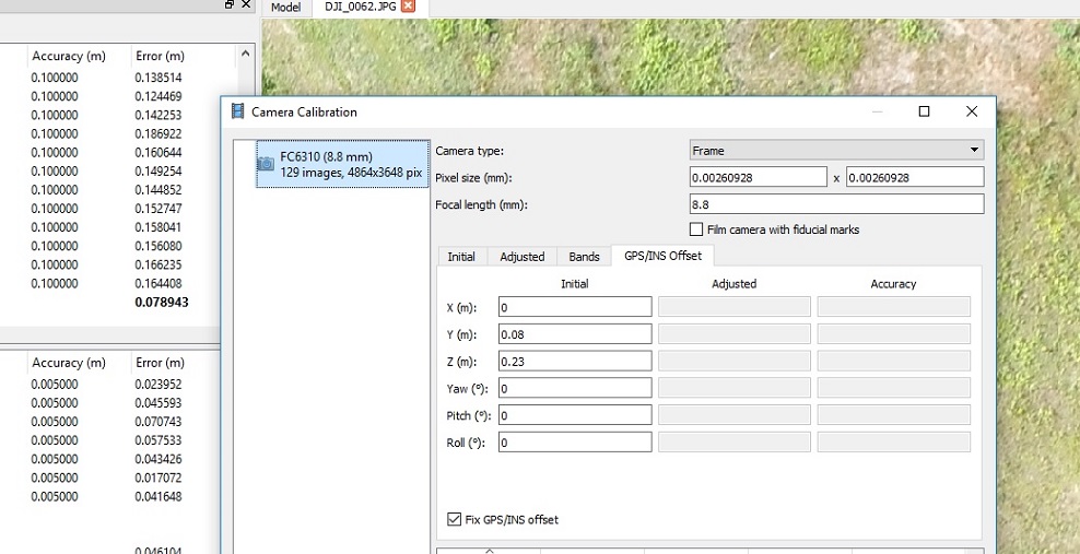
The drone comes with a precise camera center to antenna center offset value, which also goes in Photoscan for more accurate calculations.
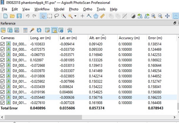
Here are some results of the image alignment.
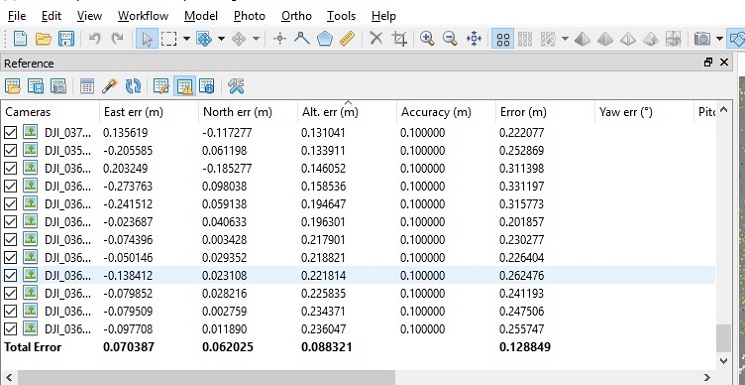
Flight 1, altitude 68m, ground speed 8 m/s. The errors of the image centers after alignment:
!
Flight 2, altitude 90m, speed 10 m/s. The errors of the image centers after alignment:
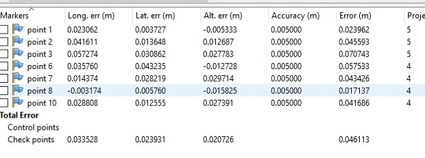
Then it was time to check the ground control points positions. After entering the coordinates of all GCPs, their markers appeared almost in the center of the corresponding GCP image.
The errors at the GCPs for the Flight 1 (altitude 68 m, speed 8 m/s):
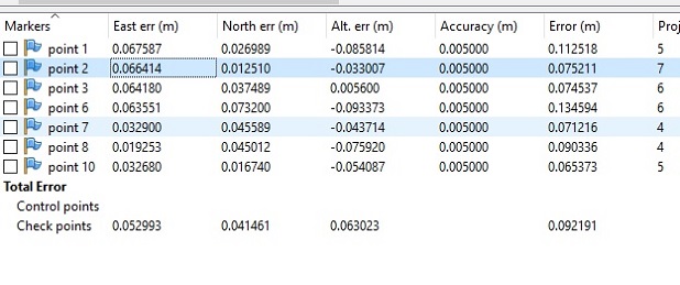
The errors at the GCPs for the Flight 2 (altitude 90 m, speed 10 m/s):
Based on the conducted test we can conclude, that using the UAV-Design upgraded drone it is possible to get 5-6 cm horizontal and vertical accuracy of orthophotos even without ground reference points (I would still keep 1 or 2 for additional control). In my opinion that is useful for surveying of 50 Ha and more. In one flight it is possible to capture about 30-35 Ha.
Thank you for reading and good luck with your surveys!
A special thanks to UAV-Design team for the affordable and easy to use survey drone.