The New ReachView 3 is out

https://emlid.com/wp-content/uploads/2020/12/ReachView3-1-2048x1152.jpg

We are excited to share the news: the all-new ReachView 3 is now out of beta! This means the app is available for download from App Store or Google Play and ready for work.

For the past months, thousands of users took part in beta testing and provided us with valuable feedback. We know many of you were anticipating this announcement, and we appreciate your support in helping us bring this day closer. ReachView 3 is now the recommended way of working with all our receivers.

Let’s see what’s inside the new app!

Coordinate Systems on Board

The coordinate system support is finally here with more than a thousand coordinate systems available. No more need for third-party software for transformation! Create a survey project with ReachView 3 on your iOS/Android device, and you are ready for the RTK survey.

The selection is based on the EPSG and IGN registries and supports thousands of different coordinate systems worldwide.

crs-selection

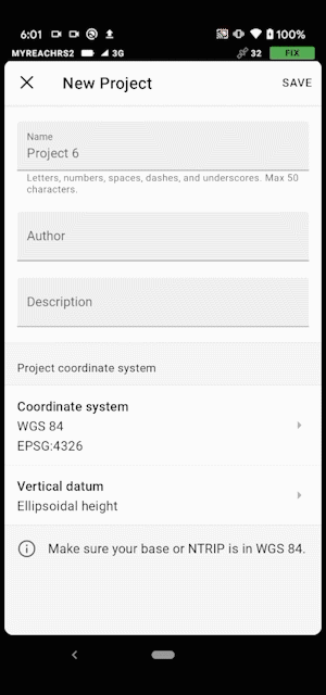
Coordinate systems in ReachView 3

ReachView 3 has built-in support for grid and geoid transformations. Choose the appropriate coordinate system, and the app will prompt you to download all the required additional files. Currently, the app supports EGM2008 and many more local vertical datums around the globe.
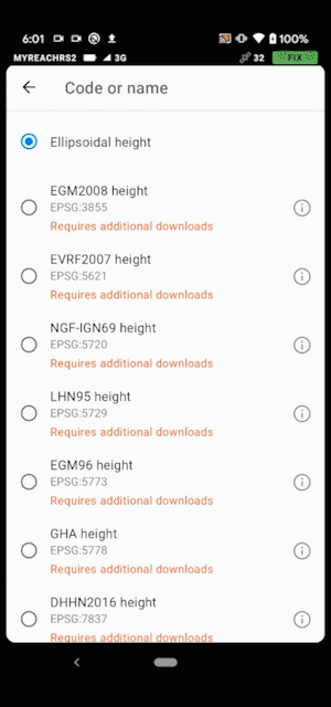
geoid-download
Geoid download

With a coordinate system support comes support for different units of measurement. The pole height settings and stakeout distances will automatically work in feet or meters, depending on your project’s coordinate system. Go to the Emlid Docs to see the list of countries that are already covered.

New Interface Allows Handling Complex Projects

You can rely on ReachView 3 when managing a project with thousands of points on the go. The new interface of ReachView 3 enables smooth navigation within the app, no matter how complex your project is.

The point collection and stakeout tools are now even more convenient to use than it was previously. For point collection, we have added time averaging, auto-naming, and description fields.

Collection-mini
Collect points without leaving the map

During point stakeout in ReachView 3, you can now move the map freely. Just use the “Zoom in”, “Zoom out”, and “Fit to map” options for faster assessment of the survey.

Survey Data is Stored on your Mobile Device

All survey data is now stored on the mobile device you work with, so you can access it anytime without connecting to your receivers.

Import and export collected data using Dropbox, Drive, Mail, or any other file-sharing app on your phone. CSV export is already available with more options coming soon.

Import-mini
Easily import points from your iOS or Android device

Export
Export to Google Drive, Dropbox, Mail, or any other app

We have reworked the antenna height configuration in the project settings. Just enter the pole’s height — the rest will be done by the ReachView 3. The app will automatically take into account thread adapter height and the distance to the antenna reference point of the receiver.

Pole-height-new (1)
Configure the antenna height with ease

Easier Connection and Configuration

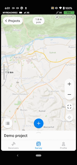
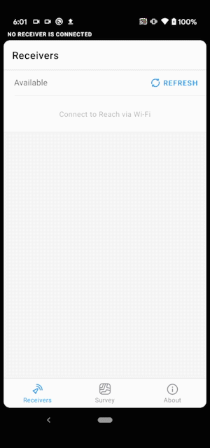
Accessing Reach with the new app becomes much easier. We have eliminated complicated steps of scanning for the available receiver and connecting to it. Once the receiver and the mobile device are on the same network, ReachView 3 automatically connects to it. If there is more than one receiver, ReachView 3 will show them in the list.

Autoconnection
The app automatically connects to the only Reach in network

With ReachView 3, the status bar is globally visible. Receiver solution status, battery charge, the number of satellites in view, the type of Internet connection―all information will be available throughout the app.

Correction Input Profiles Added

Keep all accounts for NTRIP services in one place and switch between them effortlessly, no matter how many of them you have. All credentials are stored inside the ReachView 3. You can set up the same correction input settings for several Reach units after only entering the credentials once.

NTRIP2
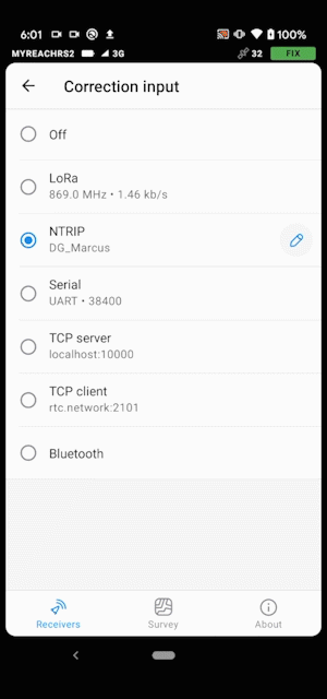
Switch between NTRIP profiles

Get ReachView 3 Today

ReachView 3 is an entirely new mobile app by Emlid. Familiar point collection and stakeout tools are now powered with the completely new user interface, coordinate system support, and ability to manage big projects. The app is already available in multiple languages for Android (English, German, Italian, Russian, Spanish, and Turkish), translations for the iOS are coming soon.

We’re looking to continuously deliver new features with a simple app update. ReachView 3 is available for all Reach devices with firmware 2.24.2 and higher.

Download ReachView 3 for iOS and Android today!

41 Likes

Looking good Emlid team, word is spreading…!

Two requests:

  1. 0.2Hz / 5s raw data logging interval

  2. On the Survey Tab, when changing Point Name or Point Description, the ‘edit’ text button is too small.
    On an 8" iPad Mini it is painfully tedious trying to press the ‘edit’ button to change the attributes of a point.
    If you can make the entire text area (existing description and ‘edit’ button) all a link to the edit modal, this would be abundantly helpful in real-world usage.

4 Likes

Congrats team on the successful rollout of Reachview 3.

Not sure if I am the only one who thinks it could be better this way for survey workflow, Point ID/Name, Easting, Northing, Elevation & Code/ Feature Code.

4 Likes

Great work Emlid! 4 different people have purchased your RS2 devices in my country based on the assurance I gave them. I’m glad after I trained them on how to use it, I haven’t heard a single complaint. It gives me pleasure to be a beneficiary your technology.:clinking_glasses: Cheers to more successful revolutionary moments ahead.

One issue ( ReachView 3 Beta - #291 by richie1aubyn ) I discovered during testing of the app in it’s beta stage has still not been solved. I trust it’s in one of your near future releases. We the users in Ghana are still waiting for the fix. Thanks!

4 Likes

Hi there,

Glad to hear your feedback!

Did I get correctly that some software you use has such requirements? If so, what’s the software?

Do you mean you’d like to have an additional attribute?

I see you were discussing this with Andrei, so it was definitely noted. By the way, thank you for sharing your good experience not only with us but with your friends too! :slightly_smiling_face:

2 Likes

Hello! Congratulations on the launch! I have used and tested this app since its inception in beta version. You guys have made excellent progress and I am really very happy with the brand and the units.

Apart from this, I always had two wishes for this app (I know it was discussed above, but I never really remember what the answer was outside of what was being considered); that the coordinates of the base can be placed in the same projection system on which we are working or at least in the meantime, that csv is also exported in Geographic Coordinates (sometines will be really usefull to have this if the point was not saved) in addition to how it is today that the field of coordinates exists in the base in actual system).
Another of the great wishes that I have, that as a Surveyor, many times it is necessary to stake out lines formed by measured or loaded points (it is something very useful when carrying out our work).
Congratulations again. Keep it up !
Greetings from Mendoza, Argentina !!!

8 Likes

Hi Svetlana,
The software is really NGS OPUS, which utilizes a 15s interval, and does not accept filesizes >100MB, which makes uploading 1Hz datasets impossible for 24hr occupations (which happens often enough).

Thus, while 5Hz is more than required (15s), it is perfect for the application, as i use other post-processing services which will utilize the 5s interval.

This cuts down on filesize tremendously, and would enable me to upload long-duration occupation datasets to the NGS OPUS system: OPUS: the Online Positioning User Service, process your GNSS data in the National Spatial Reference System

Thanks tremendously!

4 Likes

I would second this request, as the feature code is very helpful info when viewing large datasets in ReachView3.

Either “DESC” or “CODE” is useful here. (they are separate, but I’m using them like they’re the same here, because storing BOTH “desc” and “code” is a bit redundant for the level of development the app is at so far)

We typically use “PNEZD” or “PENZD” as a standard, and I think everyone will probably agree that PENZD would be fine, as we can easily switch the Northing and Easting.

Also, if there is the “DESC” field is null, you can just leave it blank when importing.

4 Likes

So where it helps simplify people’s data manipulation is where you have to take Topo shots of say a road and you want the right, Centre-line, left shots to group themselves or say some shots that happen to be of the same feature like say edge of pavement, Control Point.

Would end up looking like
Point ID, Easting, Northing, Elevation, Feature Code
1 100.000 250.000 83.467 MH [Manhole]
2 41.311 96.322 155.235 MH [Manhole]
3
4

When I capture some other feature like say a Control Point or Topo Point, I can start assigning point ID from 1 to as many of that feature I capture.

2 Likes

If this is going into the future roadmap, I would urge the development team to create different tabs for Description and Code as they are two different things and there might be another outcry for separating both if they are mixed up

3 Likes

Agreed @tisijola
So, I recommend to use “Description” for now, as it meets the most basic “PENZD” definition

3 Likes

Hello, Thank You for great improvement witch reachview 3, we are using that since beta for drone mapping (GCP measure, UAV base, UAV rover).
Probably there is a little change that can help people using that app for drone mapping. If there been posibility to have last timemark time visible in main app screen. (thats great to check if there is all ok with camera capture on drone startup)
I have also other idea, maybe there is a good idea to gave users posibility to choose favorite tabs/function(like logging, camera control etc., wi-fi off) to be visible at main screen (then timemark time may be right side of camera control tab)

1 Like

Hi rccam,

Do you use RTK for GCP placement or Static?..would like to know how you and others carry this out efficiently.

1 Like

We are using RTK method for GCP (with paid ASG Eupos VRS NTRIP stream in Poland).

And static solutions (with afterdate unpaid VRS stream) generated to obtain correct cordinates of base for further PPK calculations of UAV position.

Sometimes in difficult places for GCP measure we are also using secound receiver placed as our own base but thats realy rare.

We are using AzusRTN (receiver from @r.pazus based on reach) + emlid reach M+ on our planes

Hi Lucas,

Glad to hear about your good experience :slightly_smiling_face:

I can say that all features you’ve mentioned are indeed noted. Some of them are already on our roadmap. However, thank you for asking about them once again. It will help us to get the priorities.

Hi @geohawk, @tisijola,

I guess I got you. Do you want to manually enter these codes or create some kind of list with default codes to choose from?

Also, thank you for the clarification! I’ll pass it to the team.

Hi @rccam,

Thank you for being a beta tester of ReachView 3! It was a great help to us.

I’ve noted your requests. They will be discussed with the team.

1 Like

Hi Svetlana,

Would be nice if you provided a rich default Feature Code list and provide an option for adding custom ones.

Thanks

Hi Svetlana! Thanks for the answer.
I’m glad that mi wishes are listened !!!

About priority’s , base in projection systems I think is one of the most important things. Staking lines is an amazing features to land surveyors like me, and i think is really important. Is the last thing that is missing.

Again, congrats for all the team.

Greetings from Argentina.

7 Likes