I agree with you. It would also be good if Reachview3 can export timestamps in GPS time, that are the same that the post-processed .pos file from Rtkpost.
It would be easier to work with a stop and go workflow.
I agree with you. It would also be good if Reachview3 can export timestamps in GPS time, that are the same that the post-processed .pos file from Rtkpost.
It would be easier to work with a stop and go workflow.
Thank you @ivan.korenev
+1 for manual creation of points via coordinate entry
The new survey interface for point naming is too cumbersome. Both options for point naming need to be on the point collection screen. Pressing edit for every point then adding the name is too cumbersome. Please change this.
Hi Joel,
Thanks for the feedback. I’ll discuss it with the team.
A post was split to a new topic: Baltic CS
Strongly agree with this constructive criticism. The current naming system is cumbersome, also sometimes unclear whether the edited name applies to the most-recently gathered point… or does a change to the name only apply to the next point to be gathered?
Hi @manscuto842,
The name changes apply to the next point. Thanks for sharing your feedback!
I just wanted to chime in and offer some thoughts after having used my RS2’s and Reachview for a couple years and doing a handful of jobs with them. I also got the opportunity to check out FieldGenius Android to compare how each software performs.
The RS2 with Reachview 3 is exceptional.
I did a small experiment and took shots using both FieldGenius and ReachView 3 for two completely different jobs that were geographically about 30 miles apart. The results were extremely similar, RV3 provided identical elevation and coordinate data as FieldGenius without any issue. Huge thanks to the Emlid team for their hardwork! I can do things with the RS2 units it used to take a pair of very expensive Trimble’s/Spectra’s to do. Please let me know if you guys start making robotic total stations 
Yeah, I’ve suggested it. I seriously don’t think Emlid would… but could you imagine the excitement if they did, with the quality they already exude with their GNSS line!!!
You’d be a billionaire if a Robotic Total Station DISRUPTOR arrived on the scene. I’d make it a bit more than just the typical Robotic Total Station also. Hybrid GNSS also with 3D layout like the Leica Disto 3D, GEOMAX ZOOM 3D, TOPCON LN-100, etc etc etc.
The Robotic Total Station (not to mention just the traditional Total Station) market is a racquet gone on waaaaay too long.
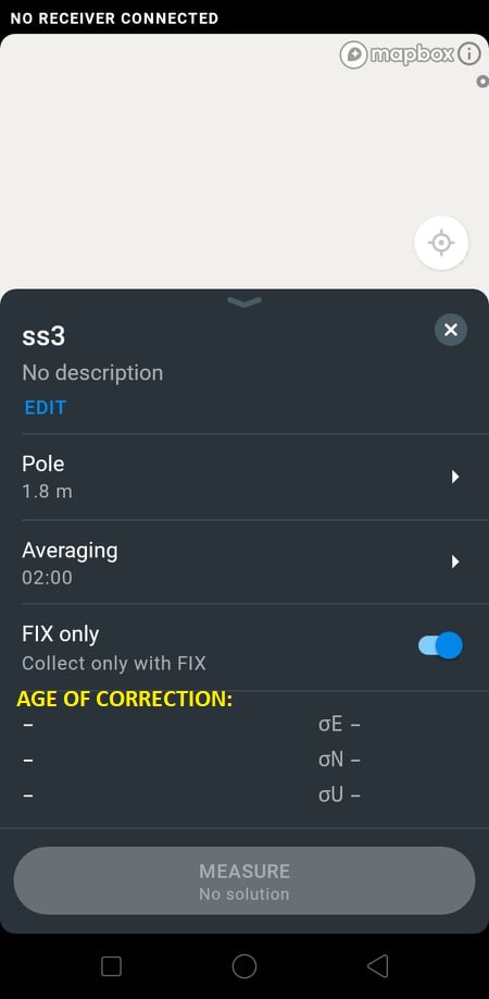
suggestion to add age of correction in every point reading in csv export.
you can use the maximum age of correction or average in every point reading?
Hi @willstar_beleno,
Did I get it correctly that you’d like to have Age of corrections as an auto-rule for point collection?
Hi, since some people already asked for a code field I would add on this that it would be great if you could simply add survey fields while creating the project. I would love to specify something like simple numeric fields (size), or option lists (gcp type) for every survey point.
Hi Julian,
Thanks, noted!
The Robotic Total Station (not to mention just the traditional Total Station) market is a racquet gone on waaaaay too long.
Hmmmm… I don’t know about that.
The economics of mass producing optical-mechanical devices that have reliable, repeatable tolerances in the 10, 5, or 2-seconds-of-arc range in 3 axes of motion are probably… significantly different, and significantly more difficult than the economics of mass-producing 100% solid state radio receivers.
I understand that. But it’s been waaaay too long, many many many years, that this market has been around with rediculous over-pricing. Technology has advanced so much since then, along with lower component costs. Tear one down and you’ll see they are no more than stepper motors, encoders, electronics and optics. Obviously certain components would be premium priced, but no where near the asking price.
A prime example is the very old Trimble 5600 series Robotic Total Stations. 1,2,3 & 5 seconds. They are a bit more involved getting everything necessary together to get the entire system working, but it can be done for $1500-$2000. The main problem with these units is battery power from age, radios and the internal backup battery failure will brick them if the internal settings weren’t backed up prior to. Only Trimble service centers can replace them etc, but Trimble phased these out, so they will not anymore or smaller service centers will do it for a pretty penny. Either way, these units work just fine like TODAYS $25,000-$50,000+ RTS. All in all, it’s quite possible and it’s NOT impossible.
Even something in the middle of the road or just above average would be sufficient for most. If your work requires precision of a gnat’s patootie at extremely long shots, then sure, go hock your house for a Trimble, Leica etc. But at least the choice would be there versus the ONLY choice have currently.
A little more time, and someone smart will come along and change all that.
Just like Emlid did for GNSS. I think most here REALLY appreciate that and are not against it.
I have a confusion in the new version of RV3 to configure the base.
Why can’t I enter the height of the base in average single, can I only enter in Manual?
Or you must first enter manual to configure the instrumental height and then go to average single?
Thank you
Hi @agrimgalina,
It used to work like that in previous versions too. Average modes calculate coordinates of phase center right away. So, there is no need to enter the base height in these modes.