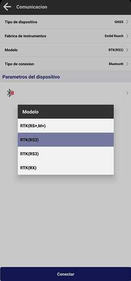
Hello, does anyone have experience connecting the Survey Master and Emlid Reach RS3 receiver together? Can anyone provide some guidance? And does TILT compensation work at all? Thank you in advance!
Hi Zoltan,
Welcome to our forum!
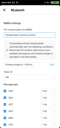
We haven’t tested the integration with Survey Master specifically, but it should work with Android apps that support receiving NMEA position via Bluetooth. Could you please try it following this guide?
We’ve added an option to stream already tilt-compensated position from Reach RS3. This feature is available on our latest firmware version 32.
You can try it, and yes, it “normally” should work via NMEA… but i think if you search past posts, newer versions are deliberately made not to work with receivers not made by the software/hardware developer.
Thanks for the quick response.
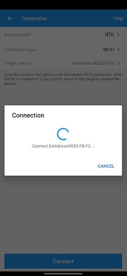
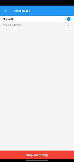
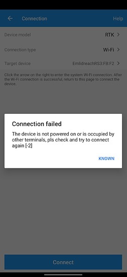
Yes, I solved these steps. The problem is that the Survey Master app cannot connect to the Emlid RS3 via Wi-Fi or Bluetooth (see photos)
Perhaps the Trimble Access 2020 is possible to connect the Emlid Reach RS3?
The reason why I ask these questions is because the Emlid Flow application contains very few functions (I miss a lot of COGO, CAD, CODING, LAYERS functions for this much money)!
Good day! If you have a Survey master version higher than 2.9.0.220525, then you will not be able to connect it to Emlid, if you want to use a higher version, then you will have to buy this program, but otherwise everything works without problems. I have not tested Tilt yet, I did not have time. Everything else in version 2.9.0.220525 works fine.
I’ve seen similar feedback from other users, and as @geotimege mentioned, the latest version of the app seems not to support third-party receivers. From our end, everything looks fine.
I’d like to better understand how we can implement them in Emlid Flow.
- CAD: Could you please explain how you’d like to use CAD in your projects?
- Coding: Are you looking to add custom codes to your objects? If so, what kind of attributes?
- Layers: Do you need to organize different data types into separate layers? Would you prefer to differentiate them by color or some other method?
Currently, we have the following COGO features:
- Traverse Tool: Allows you to create a new point relative to an existing one using distance, azimuth, and height difference.
- Inverse Tool: Lets you calculate geometry data for existing points.
Do you need any other COGO options? Which specific features would be most useful to you?
helmert.zip (1.4 KB)
Hi Inkar,
I won’t speak for Zoltan, but I can offer some COGO functions that many surveyors find useful. I will offer examples from Carlson ( https://files.carlsonsw.com/mirror/manuals/SurvCE_V6_Manual.pdf ) as that is what I am currently using.
Traverse.
From reading the manual ( Calculate traverse | Emlid Flow and Emlid Flow 360 ), it seems Emlid could add the following methods:
- Manual Traverse (see p. 407): When performing a cadastral survey, many of the older plans use astronomic bearings. Using an Emlid GNSS, those no longer apply so we cannot simply plug in a bearing and a distance. Typically, one would calculate an interior/exterior angle and use that to calculate a point.
Say one found some property monuments on the front of a lot. We will call them points #1 and #2. We wish to calculate a monument at the back. Looking at the old plan, we could find the interior lot angle. By “occupying” point #2 and “backsighting” #1, we could calculate the position of point #3.
I typically do this with an Angle Right (AR) or Angle Left (AL) option.
Trimble has a fancier option where you can punch in the astronomic bearing, it will note the difference, and you can finish your calcs using the plan’s astronomic bearings. Carlson isn’t quite as robust in that regards, so I just use the interior angles and an HP Prime calculator simulator on my data collector (DC).
-
Point Projection (see p. 389): When checking to see if a number of cadastral monuments are all in a straight line (ie. along a street), it is handy to use this COGO. One sets your baseline via 2 points and then you can check the chainage and offset of other points in relation to that baseline. This is also helpful in staking road items off an alignment if it is a straight line.
-
Point Average (see p. 411): When measuring a point, multiple times, and even over multiple time periods, it becomes helpful to have a routine that averages out the measurements using something more robust than just a mean/mode/median averaging. Something based off of least squares is ideal (ie. “Kuusniemi, Heidi & Lachapelle, Gérard. (2004). GNSS Signal Reliability Testing in Urban and Indoor Environments. 2004” or something similar).
Some others include: intersections, areas (ie. of a closed polyline, hinged, and sliding), triangle calculators (ie. side-side-side, side-angle-side, angle-side-angle, side-angle-angle, side-side-angle where all calculate the sides, interior angles, etc.), curv calculators (ie. radius-delta, radius-chord, radius-arc, and any of the spiral-arc with PC/PT, etc.), degree-minute-second (DMS) to decimal-degree (DD), lat/long to state plane/UTM, etc.
There are a number of COGO commands surveyors use. Some examples of COGO programs and their functions are the following:
There’s also the good ol’ Helmert. I have attached an AutoCAD LISP example.
There are more, but this is a good start.
Honestly @inkar.madikyzy , Emlid needs to really concentrate on providing full COGO functions for the app instead of slowly “dripping” out individual pieces that should be provided like any other survey software.
A good example as mentioned by @Jaccen is “SGS prime COGO”. It provides the surveyor with all he needs and then some. Why can’t you use this software as a guide for your development ? I just don’t understand why only “pieces” of COGO functions are released. You’ve known about the surveyors needs since at least the beginnings of your development and there have been dozens here on the forum begging for COGO since I originally bought my M2’s about 3 years ago.
You’ve made some progress slowly on this issue however a complete COGO package has yet to be seen.
Also the subscription plan really stinks as the user doesn’t really gain that much. If there is ever a full COGO package developed and released it should be a one time sale. Upgrade purchases can be an option to the user if needed. Surveyors not only look at the hardware but most importantly the software that comes with it.
This will be a major hindrance for future sales if not already. It’s great that the data can be used by third party software, but there’s something lost when the developer can’t provide a basic COGO package.
I really enjoy using my M2’S and RS2 when I can, but I also dread using the software simply because it hasn’t a full COGO suite.
Unless there is some major hardware or better software improvement, I don’t see Emlid progressing any further in the GNSS business.
CAD: if I measure a line, points can be added to the end and between points. A circular arc can be measured based on 3 points, the polygon can be closed. After that, it should be possible to correct the polygons, insert or omit points.
Coding: It is possible to choose which symbol to use at point code. e.g. wood, channel cover etc. Also, in the case of a line, it should be possible, e.g. dashed, dotted, thick, etc. to choose. And as well as to determine in which layer they should be placed. Of course, it would be possible to export them in .dxf format afterwards.
Layers: Of course, the layers can be differentiated by color and name. If I import the created .dxf in emlid flow, I only see black lines! And most of the projects contain a few layers, which would be very beneficial to display as I prepared them in advance on the computer.
And yes I totally agree with EBE111057 Bryan Enfinger! I think it is very important to develop a COGO package as soon as possible! The current one is really not good for anything!
I would say that if it takes a long time or the development doesn’t work, then let’s buy it from whoever has it and implement it in the Flow!
Yes, we who work with it every day are willing to pay the price of the software. These are the reasons why I started looking for other software instead of Emlid Flow!
I’m even willing to test the features. But I need a solution as soon as possible, because I just suffer in the field.
Jaccen, are you using Carlson SurvCE along side an Emlid Reach RS_? If so, curious what tablet or other equipment you have SurvCE running on? Thanks.
Hi SteveB.
I have used the following combos:
-Carlson Surveyor+ with SurvCE 5
-Carlson RT4 with SurvPC 6
-Stonex SRT10W with SurvPC 6
All were with an RS2 (ie. the older 3g version).
It is not a perfect marriage between the two, but it works. Some features are missing and that is no fault of Emlid (ie. Emlid is not officially supported by Carlson). Field genius officially supports it so it would probably be a better option for Emlid hardware if you also want to use a total station.
Hi, inkar.madikyzy, don’t take it as an intrusion, I just want to ask if Emlid wants to integrate COGO functions into the software, and if so, when? My free 30-day trial expires on September 6th, so I’ll have to decide by then.
Thank you in advance for your answer.
Hi @zoltan.gasparik,
Thank you for your detailed explanation and for sharing your requests! We carefully consider all feature suggestions as we work on enhancing our software. However, integrating new functionalities can be quite complex. Our priority is to release updates with maximum functionality, so there is no ETA I can provide now. I’ll keep you updated with any progress.
A big thank you to everyone for sharing your ideas! Understanding your workflows and how these functions could be used helps us a lot in planning our updates. I’ve added all your suggestions to our internal list.
I am trying these days SurPro , it has absolute compatibility with emlid and various tools. It has a 30-day trial version.
Thanks for the advice ofuentes.sigman. Maybe there is a user guide or a description of the program? I can’t find it on the alpha geo page. Is TILT supported? Which coordinate systems are pre predefined?
Hi inkar.madikyzy,
I have a few comments that could improve the efficiency and manageability of EmlidFlow.
Which is the forum where such requests or tips can be sent?
Hi @zoltan.gasparik,
You can share your comments and suggestions in this thread, or if you prefer, you can share them via support@emlid.com.
Hola…
-
How can I change (edit raw data) the height of the antenna if I have already measured the given point and only later realized that the wrong height was set?
-
Im using Android 14 system. I have 2 NTRIP mountpoints in preset in EmlidFlow. But I can’t switch between them. Or I don’t know which one is in use! What is the solution?
-
I would be very grateful if an audio signal would indicate the loss of TILT compensation. Because in a 3rd party app you can’t notice if the compensation is lost. Then it makes no sense for bluetooth to transmit the compensated data (if they are not actually compensated). And it would be nice to mark the tilt icon with red and green in EmlidFlow during the stake out process. Because it is very confusing! It’s not a problem with the measurement, because it doesn’t allow you to measure if tilt is lost, but the staking out, you can see the live data, which are either compensated or not. The TILT icon in the list is too small or insignificant. That’s why it would be good to indicate TILT is lost with a sound.
-
it would be good to upload your own sound file for the FIX and Tilt signals. Or make the sound alerts more different.
-
CAD functions that I miss: if I measure a line, points can be added to the end and between points. A circular arc can be measured based on 3 points, the polygon can be closed. After that, it should be possible to correct the polygons, insert or omit points.
-
Coding functions that I miss:: It is possible to choose which symbol to use at point code. e.g. tree, channel cover, triangle, circle, X etc. Also, in the case of a line, it should be possible, e.g. dashed, dotted, thick, etc. to choose. And as well as to determine in which layer they should be placed. Of course, it would be possible to export them in .dxf format afterwards.
-
Layer functions that I miss: Of course, the layers can be differentiated by color and name. If I import the created .dxf in emlid flow, I only see black lines! And most of the projects contain a few layers, which would be very beneficial to display as I prepared them in advance on the computer.
-
Turn on/off WMS layers in EmlidFlow
-
Why can I measure two or more points with the same point name? This is unacceptable!
-
Staking out a line is a disaster. This does not work as it should. I would recommend that if I am behind the starting point, then the value should be marked with - and if in front of it, then with +. If I am to the right of the line, then R, if to the left, then with the letter L or also + and -. When staking out, you can only see from the graphics that I should move right/left or forward/back. The data does not provide any such information.
- 1 for audible notification when tilt is lost.
I’ve had “compensated” positions being sent to third party apps that were sitting 2m above the surface , which I can only assume is the uncompensated position of the antenna phase centre


