


Hi @Zinou, I’m trying to upload the OBS files here but it is been blocked. I’m stranded now
@wizprod please the ubx data is not recognized by the post processing software I’m using (Topcon tools). It is the only software that allows me to process in my local coordinate reference system. (WAR office). I don’t think rtkpost/rtklib can do that. What are my choices here??
Convert the UBX til Rinex using RTKconv, and then import the Rinex into the Topcon tool ?
You can use wetransfer.com or similar instead.
I’ve done so but it seems Topcon tools doesn’t recognize the obs and .nav files it only recognise .19o and .19n files. Loading the .obs in Topcon tools freezes it and takes about 30mins to load it(the observation file) which then loads as hundreds of points instead of one point. And most importantly doesn’t make any vector connection with the raw data from the base or reference unit. I just don’t understand this because what I know in my country is, when I set one unit as a base and I use the other to observe points of a parcel, say 4 points, when I import them, they should all make a vector connection to the base. If a colleague has set a reference somewhere at the same time you were making your observation, you can take his/her raw reference data and the vectors will connect when you import you site points along with it. I don’t know if I’m missing s point with Emlid??
If it only accepts .19n, it means it only supports GPS?
You can setup RTKconv to only output GPS and also split up the navigation messages into seperate constellations.
Regarding reading it as 4 points, then remember that the UBX constains the raw-log from all the satellites.
If you set the RS2 to 1 hz, you will have 1 position (observation) pr second.
If you want to make 1 point from several observations, you have to either Survey them from the Survey tab in Reachview, or postprocess them.
This could then result in a .csv file containing the position and elevation, along with RMS, collection start/stop etc.
Yes @wizprod and thanks for your submissions. I tried this yesterday and it worked seemlessly. My 2 problems with that in relation to my workflow is, the coordinates I get is not in my local reference coordinate transformation therefore I cannot submit it to authorities as my processed data, it would have been perfect albeit I’ll still need to attached the raw data of each point I observe on a site for the authority to post process and get the same coordinates as I presented using our local reference coordinate system.
Can you kindly illustrate how that can be achieved with a normal video recording from your phone if that will not be too much to ask.
I cannot, but it is very straight forward in RTKconv:
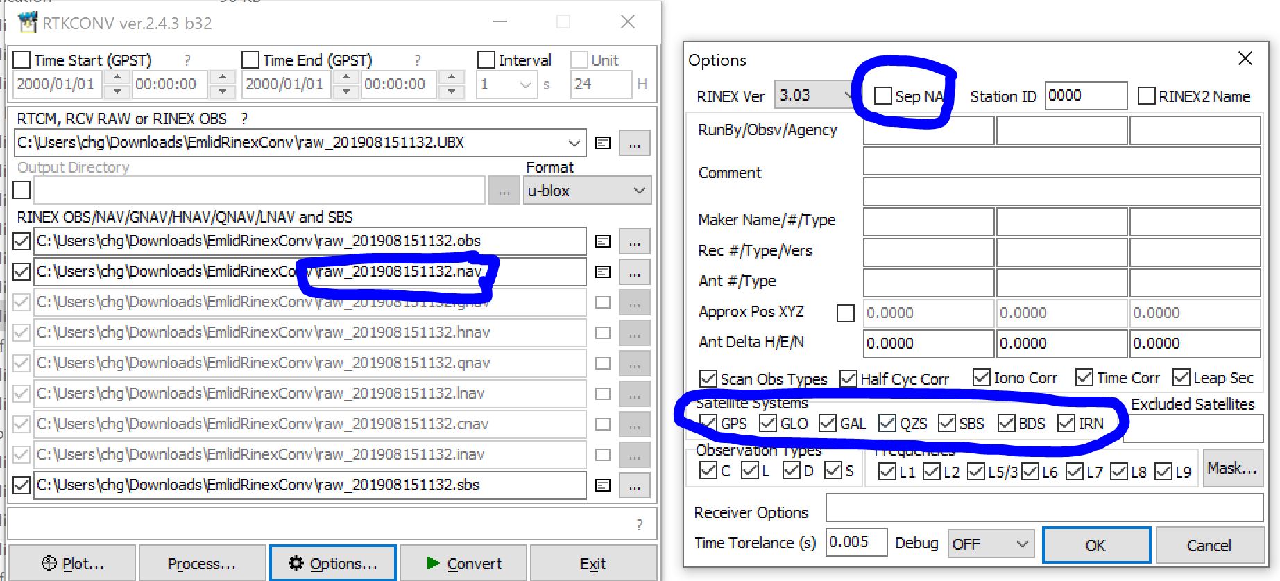
Remember that .obs and .19o are the same file, just with different endings. Same goes for the .nav
Thanks, am I supposed to tick or untick the sep NA tick box??
yep
2 posts were split to a new topic: Filling out report fields for receiver and antenna details
This topic was automatically closed 100 days after the last reply. New replies are no longer allowed.