Hi Luis,
Thank you for sharing your v2.17.0 test results with us!
May I ask you to provide a more detailed description of the issue you’ve experienced? It’ll help a lot.
Hi Luis,
Thank you for sharing your v2.17.0 test results with us!
May I ask you to provide a more detailed description of the issue you’ve experienced? It’ll help a lot.
Hello Tatiana! when I go to stakeout points that half a week ago I find differences of approximately 20 cm, I check the coordinates of the base and are correct, then I return to the same points and the difference is 5 mm? I do not understand that variation. I’m going to try switching to continuous instead of fix and hold on the Rover and see what happens. There is no accuracy in the staking and if in the lifting of points
Seems you need to stick with the initial settings you first measured with? So when you went back to check (even with a new version of ReachView), should be very close?
i.e. if you first measured with FIX & HOLD, then go back and use FIX & HOLD again? Same if you used CONTINUOUS? Stick with CONTINUOUS when you went back? Not FIX&HOLD first then go back and switch using CONTINUOUS?
maybe keep them consistent on BOTH the BASE & ROVER also?
Is your pole/antenna height remaining the same and you didn’t change it between first measuring and going back to check later?
What sucks about things like this, you’ll rack your brain over and over, and then later find out it was a simple setting or discrepancy that caused inconsistency maybe? The language barrier probably isn’t making it any easier also… so feel your pain Luis. ; )
If Tim the language is a problem. Always use fix and hold with version 2.17 the antenna heights were entered into the base and the Rover exactly. I have confusion between fix and hold and continuous but they must be the same coordinates. The value of AR is low in continuous. I’ll do some experiences and I’ll tell you
I hope you get it resolved! ; )
Also, would anyone know if being off by 20-28cm (7.874-11.024") would FIX&HOLD and CONTINUOUS even really be off that much between using either one? Seems some other problem?
It is possible that it is another problem !!
What do you think of the Topographer Pro?
welllllll…. maybe try another APP then to see? I’ve only used FieldGenius 9/10 only… (you mention stakeout is slow which I find it is also).
When I get time, I need to look into SurvCE/PC or MapIt GIS Pro (you may want to look at that also?) I have not got into Topographer Pro, but Tore has.
I keep my fingers crossed over time, Emlid will produce a FULL Survey app… they are on the right road now to it. Slowly but surely. So best to use an established 3rd party solution with maybe a data collector (or Windows 10 tablet (Surface)). i.e. FieldGenius, SurvCE/PC, SurveyPro, Topcon Magnet Field etc.
I am just not familiar yet with the Android (or even iOS)apps that offer survey features such as Mobile Topographer Pro etc. The coordinate systems and GEOIDS are not really centered around the United States either, except for MapitGIS pro I think may have NAD83? again, I really just use FieldGenius, so more famililar with it and it offers everything one would need.
I just have to get out and test stakeout with it more as it is very slow update as you mention also.
I did tests with fielgenius 10 of evaluation and it goes very well only that for stakeout in very slow on the other hand it works well. I also hope that EMLID can solve the data collection and be more complete for our use in Topography. It is not for my problem to pass geographic coordinates to a frame of reference, so for the moment I prefer ReachView
Luis,
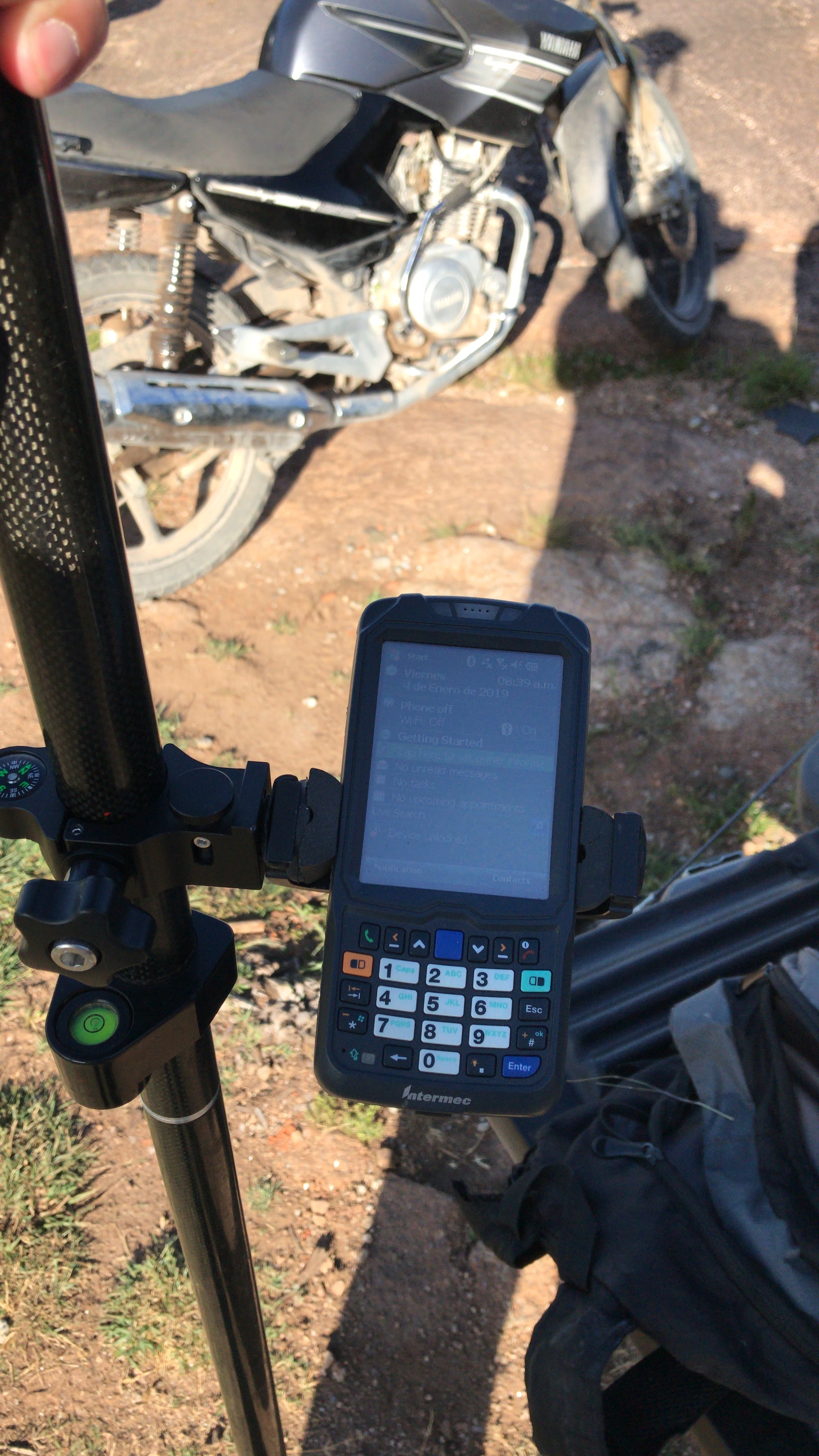
Just curious. What exact device we’re you using with FieldGenius 10 that was slow stakeout? A older Windows Mobile 6 type data collector like a Trimble Nomad 900G which am using and seems slow for stakeout?
Or are you using a Windows 7/8/10 based tablet? I have a old Windows 10 Surface Pro 1 which I still need to try to see if stakeout works faster.
Used Bluetooth communication so far only on the Nomad 900G.
I have a Emlid serial cable I still need to try with my Nomad 900G to see if the bluetooth is the problem when I ever get time.
Thanks Luis.
Luis,
There’s not enough information to draw the conclusions on why you get such results. We can help to investigate that but we need more detailed information. Please be more descriptive and follow the template when reporting an issue. This will help us a lot.
In the meantime, from your description, I can assume several reasons why you are getting these results. However, we need raw logs, survey project file, and actual (or measured) point’s coordinates to check where the difference occurs.
Overall, it’s very unlikely that the difference in your measurements has something to do with the latest ReachView update. During further tests please make sure AR ratio is much higher than 3 and keeps growing before starting collecting/staking out points. This is to make sure you have a reliable fix. You can use either fix-n-hold or continuous depending on the environmental conditions.
Apologize if the answer to this is above that this is become quite a lengthy thread. Is there a list of improvements/bug fixes for 2.17?
this thread has been split out of the initial Stakeout feature thread. (v2.17.0 is DEV version maybe?)
I think this is what you’re looking for maybe?:
Yes, the dev version. I didn’t see anything on that thread or and searches I did. I saw this, but it does not detail the changes.
Dimitri what are the environmental conditions?
Luis,
I was not completely correct here with using this adjective, sorry for the confusion.
I’ve meant the surrounding conditions such as the view of the sky, possible obstructions or vegetation nearby, sources of interference and so on.
I saw that you work in quite an open area so any of AR modes for GPS should work fine!
I was able to get the movement of my rover on the FieldGenius 9/10 screen to update faster on my Trimble Nomad 900G Windows Mobile 6.1 during stakeout etc. It was updating way too slow about every 10 seconds or so before which wasn’t feasible to work. So now it’s almost real-time!
You have to set your RTK Settings in ReachView to have as many satellite constellations as you can for your region obviouslly, but the KEY is to set the FREQUENCY to 1Hz! Not 5Hz, 10Hz or 14Hz! For some reason I was lead to believe the HIGHER the FREQUENCY the better or faster, but turns out that wasn’t the case for my situation, but the opposite. I set to 1Hz, and works quite well now. (thanks to @wizprod also as he suggested this solution months ago but I am just now getting around to using my EMLID Reach RS units again! Thank you @wizprod!)
Maybe try this to see if it helps you for faster stake out in FieldGenius.
now I do some tests and I tell you Tim. but I am convinced that the rechview when I have more Topography tools will overcome it !!!
This topic was automatically closed 100 days after the last reply. New replies are no longer allowed.