Hi community,
we have recently purchased a set of Reach RS+'s.
Today we signed up for a 3 day trial for the Topcon TopNet Live corrections and tested the accuracy with NTRIP set up on the base.
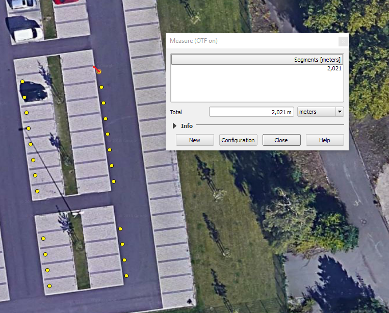
Once we finished our survey with the rover, we opened the points in QGIS and found that the measurements are off by roughly 2m.
I am sure someone will load your files and check it out though.
Also, do not worry about the Reach RS+'s accuracy, they are DEFINITLY cm accurate in RTK and even more so post processed. You’ll get it figured out with the great help here!
You might be familiar with QGIS but I will suggest it anyways. Your coordinate systems are very important when using google maps imagery. Imagery can jump around a lot. Does it get any better if you zoom out? Otherwise, in my experience, I would have to say that google maps can easily be out several metres or more.
Thank you for the replies! i must admit i’m not very confident about the accuracy of the base map (google maps). I’ll measure a geodetic survey (reference) point today and share my results.
there are not too many decimals on the reference point you are using. Do you have a more precise coordinate?
The UTM is only within 1 meter (no decimals).
What CRS do you normally use? And what CRS are the NTRIP stations set too? It could be an epoch based conversion from this to WGS84. So your reading is where the point was at a set time. If you set a known coordinate as the base I assume you will have no issues. Another option is to measure the offset by averaging a readings on know points and apply this as a correction or find what it corresponds with.
I am having similar issues in Australia but am sure the issue is in CRS/geoid conversions. The same applies precision is great but haven’t yet cracked the positional misalignment when using Ntrip corrections.
Can you try just using the BASE and ROVER and LoRa without NTRIP to see what you get?
What do you get if you use JUST the ROVER WITHOUT the BASE and NTRIP?
Is your antenna reference point (ARP) heights correct on your BASE and ROVER? More particularly when taking the base into account? If your base averaging is off, so is your rover.
Yes, the reference point you used came from a site called GeoHack, so I don’t know that you want to determine the accuracy of your Reach based on that
The published coordinate you used might be correct, but to what accuracy? in what year? in what CRS (Coordinate Reference System)? who was the authority that determined it?
I’ve repeated what was already said above, but it is really important to understand and learn how to compensate for the different variables.
I use WGS84 and the NTRIP station is set to the same, as well as QGIS.
I will try these asap.
I measured the rover height before starting the survey then entered it in the ReachView app.
An average FIX was accumulated on the base for 15 min.
I was using that website since it listed all Reference points available in Germany and it is available in English. The official website (German only) is this: Reference Point Mülheim
Published in 2014, WGS84, measured and placed by the German department for geodata management, land registry and Cadastre.
Don’t get me wrong, that’s what i’m trying to achieve. I’m a fan of Emlid already
I went to the linked German site and it appears to be of a general nature and catering to people with mobile phones or handheld GPS. There is not a reference the to detailed data that one would expect for a proper survey monument. I suspect there is another place (maybe not public?) where you can get the detailed data, including the accuracy of the published coordinate and when it was last checked. Additionally, you might see a figure for drift per year and possibly ties to other nearby survey monuments.
All in all, it doesn’t seem to be the right source for checking against your centimeter grade equipment. Hopefully a better source of reference data will present itself to you!
I get a 1,17 meter offset to the east trying converting from ETRS89 to WGS84 and comparing the distance.
Can you try with another point?
Google maps is also off by 1-2 meters, looking at images from the ground.
At this point in time I would suspect your NTRIP input to be flawed or in some other reference system, thus affecting your base, which will in turn affect your absolute coordinates of your rover.
Can you try postprocessing both base and rover using EUREF/IGS stations?
I am wondering if he just sets the base up on a known point, he can enter the “accurate” known point data in ReachView and use the rover to verify again via LoRa.
If using NTRIP, does he even need to have the EMLID Reach RS BASE in the equation? Could use that as an additional Rover for surveying?
Or is it better to use NTRIP with the Reach RS Base (corrections from CORS service?) and then corrections from the Reach RS Base to the Rover?
In the initial post, maybe this is the problem? It’s an AVERAGED fix at the RS base? So maybe 2 different reference points versus just one? Rover going from that?
In theory you could do without a base, however, if the NTRIP station is far away, it is more precise to have the base close by with a known coordinate.