


I’m not sure how i would do this. If the base is placed over a known point it would physically occupy that space and would hinder me to measure it with a rover. I’ve also read somewhere that the rover shouldn’t be too close to the base when the the base is correcting it?
@darellon
There must be other monuments in the area with better descriptions and more precision?
I think we somehow need to rule out that this specific monument has imprecise coordinates documented. Otherwise it is a wild goose chase…
1 Like
Good point. Contacted the local city council yesterday since they have a bunch of measuring points distributed throughout our city. Their statement over the phone sounded promising and hoping to get some accurate points near by.
3 Likes
Hi,
As was said earlier, Google maps aren’t precise enough to use it as a reference standard.
I’d also recommend looking for a more reliable source of reference data.
3 Likes
The interesting thing is that the points are all off by the same amount in the same direction in the photo. That points to the coordinate system and not that hardware. Are you SURE you are using the same coordinate system as the map software you’re comparing the points to?
1 Like
Hey @darellon not trying to beat a dead horse to death, but for cm accuracy image comparison never rely on google maps or any other third party aerial service for that matter…non of them. Unless they are an actual photogrammetry aerial service provider. Maybe like everyone has mentioned your NTRIP provider may be the issue. I would not worry about rod heights being wrong, because your issue is horizontal, a vertical height would not change the horizontal outcome.
I would do as @timd1971 suggested and find a known benchmark and occupy it for 45min.-1 hour then save. Next create another project, with the rover still occupied over the BM and connect to the local NTRIP and record. Do a comparison of the two.
Is this correct?
Seems antenna heights would also need be taken into account for proper trilateration calculations even if still only concerned with horizontal measurements since all x,y,z points in 3d space.
First let me just say I’m not a GPS or math guru. I’m assuming no matter what your rod height is the frequency of the GPS ground station sending the signal to the satellites is not changing, I dont think changing the rod height is changing an XY value on a plane. Like you mentioned on trilateration the speed of light *time difference = distance. If I put 10000m in my height and I’m actually at MSL, wouldnt the XY still be correct like a plumb bob? Within the earths atmosphere of course 
I just don’t see the z elevation changing the outcome of an XY value, maybe someone can chime in that knows more about this then I do?
Understood, but I just need clarification in case vert antenna heights of both the base and rover are important in calculating the resulting x,y,z cords. If they are, I don’t want to go on thinking vert height doensn’t mean anything even if just concerned with x,y horizontal measurements.
I probably am not understanding correctly, but seems if the Z height is different than 0, this would affect the X, Y resulting calculated distances also?
Thank you Garrett.
Case closed?
2 Likes
When I get time today, I’ll take a look at Mark’s video again. I’ve seen his stuff, good learning material.
Thank you.
The city council sent us coordinates of some recently measured points that are meant for land registry purposes.
Results:
(Red dots: Reference points from the council, Purple dots: Reach RS+ measurements)
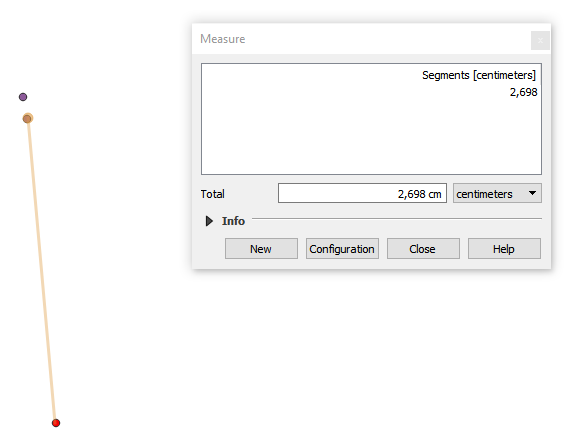
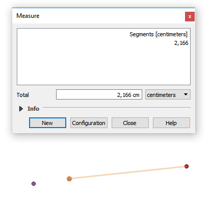
Got very excited seeing these  and will play around with the settings of the devices to get even better results
We did this survey with a different NTRIP correction service for the base, so i’m guessing the CRS of the previous correction service was the issue as was stated in some posts above.
Thank you very much for all your comments and help!
5 Likes
Awesome to see! Glad you had success!
1 Like
Curious, how does your GoogleMaps base map look now compared to your initial post?
1 Like
I’ll measure them again in a bit and post the difference
You don’t have to go out of your way!
Glad you found your solution!
i’m curious too 
Remember that when doing any surveys always keep all the relevant files and logs. When possible also conduct a number of independent checks on known points with the same settings. If you do this you will always be able to work out an accurate correction if your original data is offset. Not sure how it is in Germany but generally accurate survey point details are available online. In Australia for instance I can look up control points along with location sketches. With the new setout features I can also preload these into the Reach before the survey.
An important part of any survey work is to be able to verify and check accuracy both during and after the activity
2 Likes