


Hi. We have recently completed a drone survey a large regional UK airport. We have a Reach RS2 and were using for GCPs with our M300 drone. We noticed inconsistencies, even though we had a fix all the time. Low PDOP of 1-1.5. 30-40 satellites in view. Using Premium Positioning RTK NTRIP correction and working in OSGB.
Repeat GCP measurements were off by 20-30cm in both x-y and z coordinates when checking the spots the next day. Yet kit works well normally? Is it RF interference from the airport (we were working on the apron)? Or something else.
Thanks and hopefully someone will have a view!
1 Like
Seems like some sort of check needs to be incorporated in the Emlid Flow software? I.e. Age of Corrections at top of interface?
This might be something else though.
1 Like
As @EBE111057 has mentioned in the past… maybe read up on this?
2 Likes
Yep, there was a major G4 flare event 03/27 and 03/38. There was definitely some disturbance on HF radio and GNSS signals.
I usually look at this every day.
https://www.swpc.noaa.gov/communities/global-positioning-system-gps-community-dashboard
and at the NASA SDO (Solar Dynamics Observatory). It usually has a 30 min latency, pretty cool imagery of various observation wavelengths of the sun with some having 48 hr loop videos
I sometimes visit the site and leave the imagery running on my front office computer. Clients are usually amazed
5 Likes
Thanks for this. Are these G4 flares likely to last for minutes or hours? Could it affect data collection over the whole of a day. We had an M300 drone (with RTK) flying at the same time and that seemed to produce some good maps. Its just our GPCs look out?
1 Like
It can last for hours yes.
However, how is the nature of this offset? Very constant, or random on all 3 axis?
1 Like
Can try and compute the offsets, so it is clear if the offset is constant from point to point?
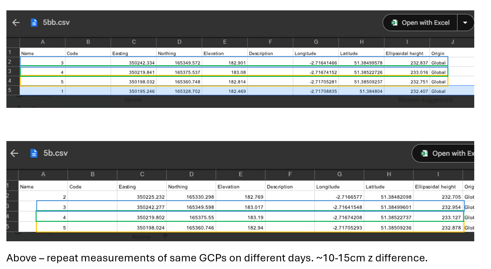
I had looked at that but they seemed inconsistent. I’m attaching the original files
7b2_verify.pdf (41.7 KB)
7b_verify.pdf (40.1 KB)
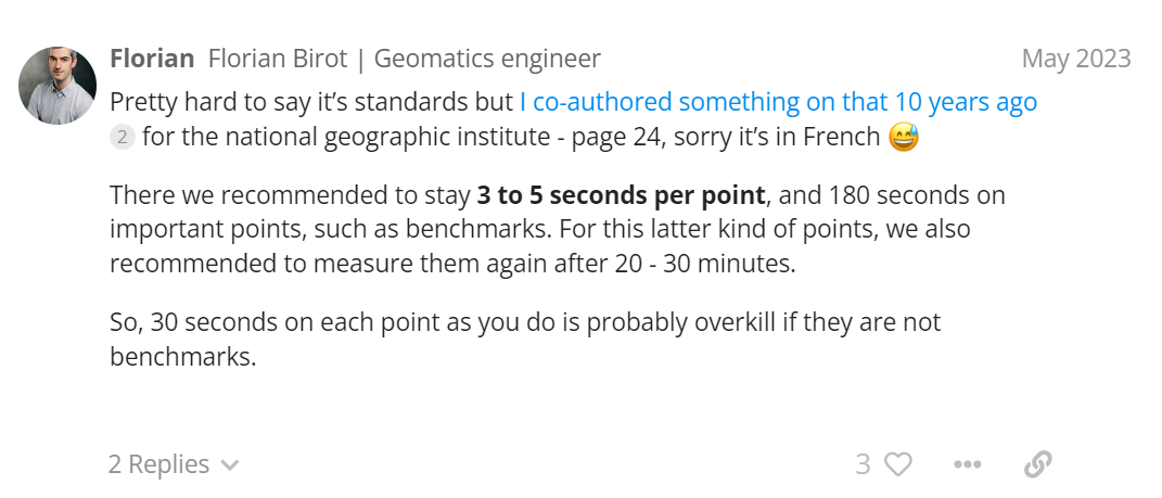
What were the observation times for each control mark ? Time on station is imperative for accuracy. Our procedures for observation of control marks if using an RTN service is a minimum of 10 minutes and revisiting 24 hours later. If performing a static campaign, 1 hr observation times. We using commercial PP software.
2 Likes
Probably only 5 minutes. Is that too short?
Your delta’s of points 3-5 aren’t very good, however if your doing any kind of precise work observation times need to be increased and re-observed for a sanity check, especially airport work.
Point 3= 0.057N, -0.026E -0.116
Point 4= 0.039N, -0.013E -0.110
Point 5=. 0.008N, 0.002E -0.126
We’ve only done 1 airport project, the FAA standards were pretty tight i.e., 0.01m accuracy RMS for all observation of control marks and the raw data had to be prepared in NGS “bluebook” standards for submittal to their database. We were using Javad receivers and occupation times were 1 hour with re-observed 24 hrs later. Imagery was provided by Sanborn.
We used satellite planning software so PDOP was below 2 for observations
Using Emlid’s receivers you’ll have to increase observation times to a minimum of 1 hr and possibly re-observed 24 hrs later. Even using an RTN service, I would observe a minimum of 30 minute’s and re-observed 24 hrs later.
2 Likes
Thanks for this - do you think we would get a surveyor with Trimble kit to help?
2 Likes
I would definitely call a professional land surveyor. He should be using more precise capable equipment . He should observe static data. What are the accuracy standards and who is requesting this ? Observation techniques should be based on this.
There’s nothing wrong with Emlid’s equipment. A lot of issues are caused by inexperienced users and lack of knowledge. With accurate observation times and procedures, Emlid’s equipment is as accurate as any other. Time on station is imperative for an accurate work.
6 Likes
Thanks - thats useful. They really want <30mm accuracy
2 Likes
![]()
We are VERY LUCKY to have @EBE111057 PROFESSIONAL REGISTERED SURVEYOR here in the EMLID community. ![]()
6 Likes
To clarify @excellent.geography that is NOT aimed at you, but from reading over the many years here, seems LOTS of this occurs with new users that are NOT qualified much less registered surveyors.
1 Like
Yes - this is all true. Wasnt seeing the significance of observation time for taking this kind of survey work. @EBE111057 - appreciate all your input to this conversation.
2 Likes
2 Likes
Well, there’s nothing wrong with his methodology, however from my experience if using an RTN 10 minutes is well worth the extra time. You should be logging raw data per point and this is satisfactory for PP to a local base also logging data onsite. Short observation times as you described are not sufficient for PP and in my opinion you are taking a big gamble with the accuracy of your observation with such a short time on station.
In our boundary surveys in high multipath areas using our state’s RTN, we observe 10 minutes per station along with a base also logging onsite. We use our Javad receivers for our boundary surveys and control surveys. They are very expensive receivers but well worth the money for our use. Usually our baselines are approximately 2-3 km. I always PP our data and compare the RTN positions. They are always within 2-3 cm, sometimes less than that. We use Javad, Emlid and Trimble equipment. I usually use an Emlid receiver as a base.
As discussed in another post, short baselines are your friend as well as time on station for sufficient data to PP. This will ensure that the point measured is as accurate as it can be. I despise re-observing a project… I lose valuable time and money.
2 Likes