


I’m setting up my new Reach RS+ with my local VRS RTN (it says connected under correction input) then under position output I connected it to an android phone with ESRI Collector on it and changed the GPS receiver to the RS+. I took it outside and its using 16 satellites mostly green bars but my PDOP in Collector is well over 18 feet. What could I be doing wrong here and how do I troubleshoot it? In the ReachView status screen it says LLH ± 0.0000000m which seems wrong, and I have no idea if/how the corrections are being applied. Thank you and sorry for the newbie question
Hello,
What’s the solution status you see in ReachView Status Tab?
I think I figured it out… I asked the RTN office about the mount point and format settings and changed them to VRS_RTCM31 and RTCM3 and now i’m seeing the base satellite info and getting a fix once in a while. One additional question I have, I have it set to “fix-and-hold” but my receiver often jumps back and forth between fix and float in static mode. How do you get it to stay in FIX status long enough to take a point?
Hi @electricblue,
-
If you’re working in static mode be sure that Reach is stable during measurements.
-
Also, you can wait a bit longer until you’ll get high AR validation ratio values.
-
Be sure that your local VRS RTN provides stable correction output. How far is your base located from the rover? Do you have a stable Internet connection?
I’m not sure how I can find out how far away the station its connected to is, they have stations all over the state, 30km, 60km, and 20km away but I have no idea which one the Reach connects to or how I would change it. I just tried to capture some survey monuments and got some disappointing results, 48cm+ off.
If you’re that much off, it is not likely to be the reach, but the NTRIP provider not sending corrections in wgs84.
Also, if using a VRS, you baseline should be quite short. That’s is the whole point of VRS.
my baseline was a couple meters in both locations, is the baseline the accuracy of the base station, or the base stations accuracy for use in my location? They send corrections in GCS_NAD83(2011), is that a problem?
Yep, that’s likely to be the reason for your offset. Emlid works with standard GNSS wgs84 + gnss elipsoid.
I spoke with my local US Geodetic Survey office and it sounds like everyone in the US will be using NAD83(2011) until 2022 
Did some more testing, this time straight WGS84 -> WGS84 in Collector, RTK Fix right away and the result was 2.43ft off
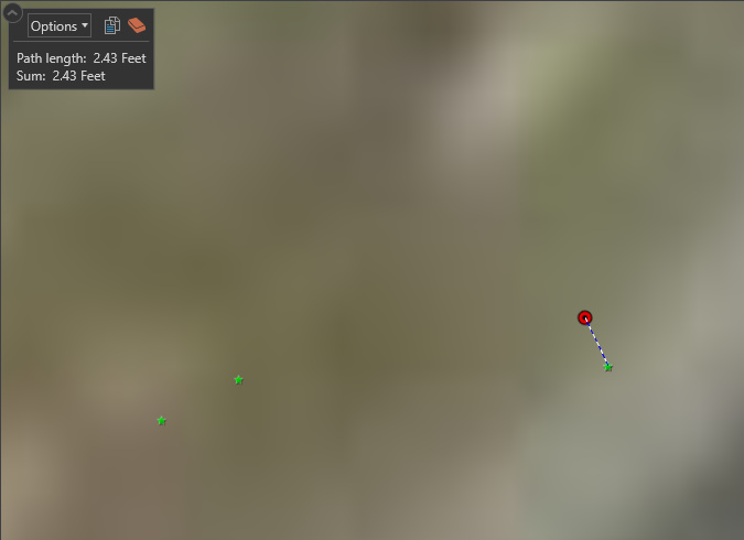
Which I thought sounds very familiar, probably because its likely very close to the shift between NAD83 and WGS84 in my area
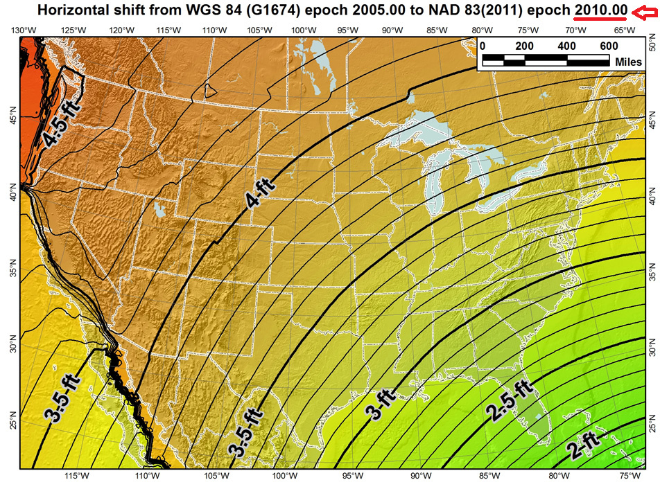
So maybe my best bet to avoiding post processing hell is a const shift of 2.43ft in that direction? Or could there be a more elegant solution? Maybe some way to do the transformation after the fact (or Emlid could add a coordinates dropdown in Correction Input settings lol)…
I used this website to transform the point and it’s only 5cm off!
https://tagis.dep.wv.gov/convert/
This accuracy would be perfect for my use if I could somehow make it automatic. What is the best 3rd party data controller to make this happen in real time?
Hi @electricblue,
I think that the best way to do it if there’s no WGS84 NTRIP nearby is to reproject all your point in GIS after collecting. I’d recommend using QGIS for that workflow.
Yes I did something similar
Thanks for your help!
This topic was automatically closed 100 days after the last reply. New replies are no longer allowed.