


Hello! How can i see the .pos file obtained from rtk lib on google earth? Thanks in advance!
Also, how can i transform the pos file in a dxf file?
There is a button to export a KML or GPX file which is a recording of the track and waypoints. Both can be imported into Google Earth.
Do you mean transform the coordinates in CAD or convert the POS data into a DXF?
1 Like
Hi SAM,
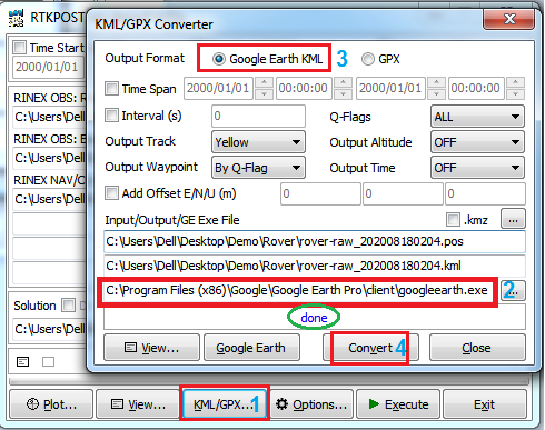
Just follow this screenshot below 
2 Likes
The pos data in a dxf file would be wonderful. To be more accurate i think i need to obtain the coordinates, and then trasform them in my system coordinates.
Thank you!
We normally use QGIS. You can import the GPX file from RTKPOST and export that as a DXF in a different coordinate system.
1 Like
You can find a lot of converters in the net the easy way is to transform Lat/Lon/Ellip Height to XYZ in UTM format.
Maybe this site can help you to transform directly online :
2 Likes
2 posts were split to a new topic: PPK with RTKLib
Thanks!
This topic was automatically closed 100 days after the last reply. New replies are no longer allowed.