RX issues with accuracy

I’ve bought 2 of the RX units and talked a guy I know into buying 2 as well. Neither of us are impressed. They do not do as well as the RS2 or RS2+ units. Using the same correction service, with the same pole in the same place, just changing out the GPS receivers, I regularly can get 1-2cm precision with the RS2 but closer to 30cm with the RX units. I did this same test several times over the course of several weeks and only once did the RX match the RS2 in accuracy. It was on the day with the most pristine weather imaginable. Any other time, not so much.

The RX does seem to do okay with a base/rover setup with a short baseline. I suspect the RX is similar to the RS+ units, in that it can technically get 1cm but you shouldn’t hold your breath waiting. I can find a use for the RX’s I already own, but I won’t be buying any more.

@rpc78 - Hi Ryan, thank you for posting the results of your tests. One thing I wondered about is related to what Michael was mentioning. I understand that your tests involved the same correction service, and just want to make sure I understand (what I’ve only assumed) that all of your tests used the same Android cell phone, had the same GSM/ LTE generation; e.g., 4G, the same number of bars, the Emlid Flow app, and we’re only talking RTK and no post-processing. Please affirm which of my assumptions are correct and which are not.

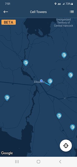
The number of bars displayed in the upper ribbon of your Android device is a simplified indicator. A better way of gauging cellular network signal strength and speed is using Opensignal. Opensignal is a free to use, advert free mobile connectivity and network signal speed test app.

For example, just sitting here in the office my Galaxy S23 is showing 5G with 4 bars. Opensignal shows a latency of 51 ms and a download speed of 151 MBps. If you try these tests using Opensignal, be sure to turn off your phone’s WiFi.

Another thing to be aware of is switching towers. Tower switching is transparent to the user and is continually being done as signal strength from the tower to your device dips, and the network switches to another tower with better signal strength.

For example, again, just sitting here in the office with my Galaxy S23, 5G with 4 bars. Opensignal shows a latency of 46 ms and a download speed of 162 MBps.

The really nerd-cool thing in Opensignal is the map of cell towers. In test-1 above, the map showed that the device was connected to a tower-1, and in test-2 connected to a different tower.

Years ago, we used to have to do mission planning in order to make sure we’d be seeing enough SVs. Now we need apps like Opensignal when doing Network RTK.

4 Likes

Wow, that’s a cool website and app !

Thanks for the suggestion !

3 Likes

Better late getting back to this than never, I guess.

So the answer to your questions is “yeah, kind of like that”. I haven’t tested this since I last wrote on here, but on the different occasions I experienced this, I used the same phone, or sometimes that phone and a tablet, but I purposely took shots with both mobile devices hooked to both GPS units, using each device’s 4G connection, my home wifi (I was testing right off my back patio), and even each other’s hotspots. To be honest, there were shots mixed in where the accuracy would go up to close to a meter, and those were cases of the units disconnecting from the phone or tablet, but I was mindful of those types of issues. Any latency or speed problems would have affected both GPS units equally, in a somewhat controlled testing environment.

From my limited comparison of the RX side-by side with the RS2 or RS2+, over maybe 5 to 7 sessions of taking about 10 shots with each unit, usually using the same phone and internet for both GPS units, but occasionally switching if the I suspected network problems, there was only one time I can recall where the RX got below 1 inch. I noted it was a clear, sunny day. Many of the other times, it was after dark and there was enough fog in the air that I could hear the electricity ionizing the water droplets along the powerlines, and every shot would be around 11 inches. The RS2+ always got down to below an inch, usually about 1.3cm.

I’ve tested it another time using an RS2+ as a base and the RX as a rover, both of them being in the same yard. Those shots all came in around 1cm, and I shot about 250 of them really rapidly.

***any reference to precision or accuracy is based on the GPS meta data.

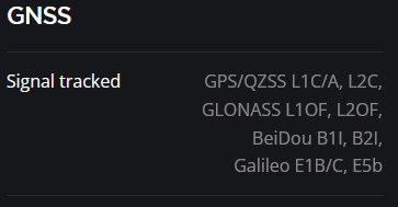
Could it be that the RX is only single band, like the RS+, where it’s technically capable of centimeter RTK, especially when working with a short baseline, but it doesn’t perform well in less than ideal environments?

Hi Ryan

image

Both RX and RS2+ lists identical specs.

5 of the past 6 weeks I’ve spent full time testing the RX in a variety of areas having a wide range of cellular signal strengths as well as a wide range of GNSS environments ranging from friendly to only appropriate for total station locations. These tests have been performed pro bono for an Emlid dealer, E38 Survey Solutions and with much appreciation for lending the equipment to me for an article I plan on writing later this summer.

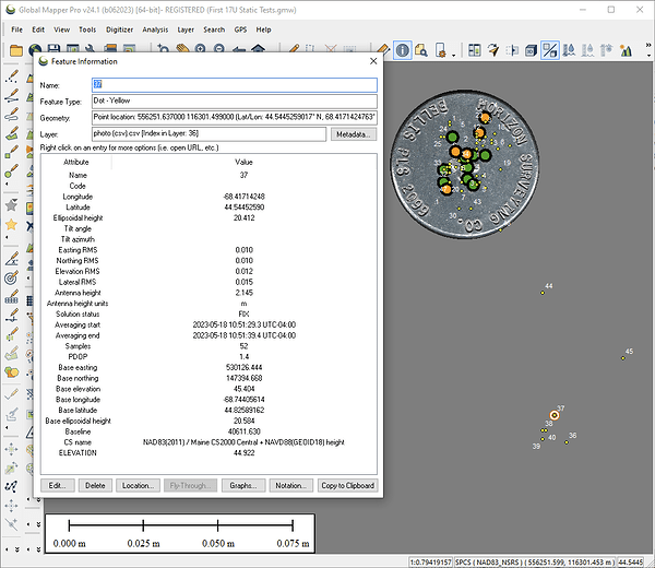
Most of those tests involved the RX receiving corrections from the MaineDOT’s RTN, and mostly using the VRS option for a mount point. Some single MEDOT CORS-baseline tests were performed also, but because the baselines were 40 km, the results were much better sticking with the VRS option. For example, single-baseline results didn’t land on the 2" diameter survey ID cap:

This isn’t to say that all points collected by the RX using the VRS option landed on the mark, though throughout the entirety of my tests, generally and horizontally speaking, most of them did.

2 Likes

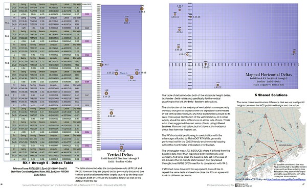
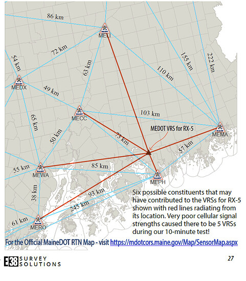
It appears the baseline distances between cors are 200+km ?

I’m not sure I would trust a vrs station solution with those kind of baseline lengths with that short of observation time.

Best solution is observe longer observation times at different times of day for those distances or use locally established positions via another receiver on the project site with short baselines.

Computing a vrs station from long baselines for short observation, i. e. realtime RTN is not good.

4 Likes

@EBE111057
Thank you for noticing this Bryan. I’m embarrassed to no end for not questioning this at the time when I created this illustration. I will fix this drawing immediately but wanted to just stop and say thank you. The distances are wrong, indeed! There isn’t any excuse for my oversight, but there is a short explanation for my bad. More on that after the fix!

Kind regards,

Kelly

1 Like

I thought there was something wrong, no problem with apology. We all make mistakes or blunders. My brother usually catches mine as he’s always pushing me to hurry up. This is from his 24 yrs in the military with his “military mode” attitude.

I like how you use the GM Pro for your report ! It’s pretty cool to see that. I’ve never thought about using it as you have. I like the report style, very informative and easy to understand !

I’m usually using GM just for GIS functions and importing data or exporting LIDAR/vector/raster info. It’s great software even though it’s a little pricey compared with a year or two ago. They’ve gotten proud of their product.

Thanks for your informative report ! I’ll have to try and use mine like yours when I get time !

2 Likes

Just to be clear, the report was assembled using Affinity Publisher 2. The map showing the bad distances between CORS was made in Global Mapper, exported in PDF, then inserted into AfPub2 and was where additional graphics and text were added. The deltas table and graphs were made in LibreOffice Calc. The table was exported as a PDF and the graphs were exported as SVG and EPS.

1 Like

The previous image (above) related to the bad distances shown on the network map has been deleted and the revised image has been inserted in its place. Below is a larger version of just the VRS map.

As mentioned earlier, there isn’t any excuse for my oversight, but there is an explanation for my bad.

Briefly, in Global Mapper I created a gridded surface using the using the (19) MaineDOT CORS - all 2D only; no Z, flattened. As part of that process, the option to save the TIN was chosen. The TIN’s area features were converted to closed polylines which were then split into single line features. These lines features were then attributed with their respective measurements and the LENGTH attribute chosen for the labels. How I messed this up the first go around remains unknown even after I spent the entire morning screwing around trying to repeat my mistake (Rage over a lost penny :wink:

2 Likes

Curious if you happen to also shoot the points using the Javad equipment receiving corrections from the MaineDOT’s RTN, as another point of comparison with the RX receiver.

1 Like

Good question, and full disclosure: the DPOS results weren’t actually from Javad gear, and no, I didn’t have it connected to MaineDOT’s RTN.

The units that I used for the baseline dataset for this test series; i.e., 30-minute static, 30-second sampling, GPS and GLO only, and post processing through DPOS, were Topcon HiPer Lite+ units. These units are quite close to where they were developmentally when Javad sold his Javad Positioning Systems company to Topcon. In fact, they’re close enough that I’m able to run them via JMT (Android) and then post process the .jps files through DPOS. JMT is also flexible enough that I was able to add a custom antenna profile to it, and that profile gets recorded along with the SV observations.

5 years ago I retired and sold all of my field equipment to a fine young man in western Maine, Isak Porter. I miss the LS & T2, but know it’s serving him well and helping in supporting his family.

3 Likes

Thanks Kelly for taking the time to explain some of the process behind the testing.
Interesting, that you were able to use the JMT app to run the Topcon receiver and process using Javad’s DPOS. But like you said, Javad’s technology was the behind the system he sold to Topcon. Quite interesting to read about his accomplishments during his lifetime. I recently had the chance to pick up an used LS & T2 myself and I’m slowly learning the system. Look forward to reading your full report on the RX. Regards, Mark

3 Likes

This topic was automatically closed 100 days after the last reply. New replies are no longer allowed.