


RTNFriend is using slices of EGM2008 model, which is very accurate, here in my country it checks to precise leveling benchmarks within 5-10cm.
Accuracy of 5-10cm is pretty good. Is it the same for all other places?
Just an idea. Maybe Emlid should integrate your app features to its ReachView app 
There were accuracy estimates somewhere on this page NGA Geomatics - WGS 84
One of the (exe) programs should provide it, forgot which one.
This site is where I get geoid from. The global model is about 700mb which does not make sence to handle and keep it on a mobile device. For this reson I cut slices of it for countries, Users should select their country (EU for eurepe, , EUN for scandinavia, there are many other countries as well) and the app will downlond and use appropriate slice of egm2008
hi there, i’m in Zambia, can you make a geoid file for me?
Ok, will post download link tonight here, you will have to place the file in RTNFriend folder on your mobile device.
It will be downloadable from whithin the app in next release 1.26
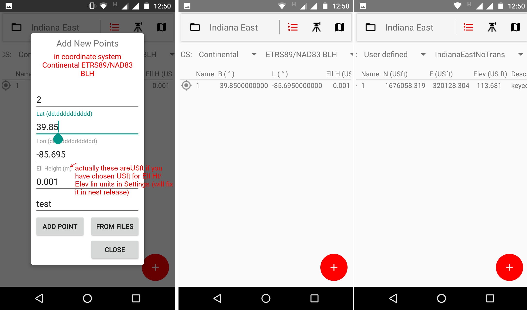
I am trying to define NAD83(2011) / Indiana East (EPSG::6458) but is seems to be off. Can you verify how to input the a,b ellipsoid parameters?
Please try this link egm2008zm.dat or this one: egm2008zm.dat
Please verify the model by taking RTK shots on several leveling benchmakrs. If you see constant difference it can be adjusted by adding or subtracting it from Antenna Height during survey (H.I. field in Survey tab - Instrument icon) - but this is really a dirty trick.
Hi, I need some more time…, are Northings and Easting of EPSG::6458 in meters of US Survey feet ?. I thought US is all 100% imperial. I assume the units are (m) as epsg says.
I will get back tomorrow., I got stuck on scale factor in 7-parameter helmet transformation from WGS84 to NAD83(2011)
you’re doing just fine… what you are doing definitely takes time to accomplish and probably isn’t INSTANT. I am sure many of us can patiently wait for your work like most other developers do anyways. ; )
Thank you.
Units are US ft. I also use geoid12b for orthometric heights.
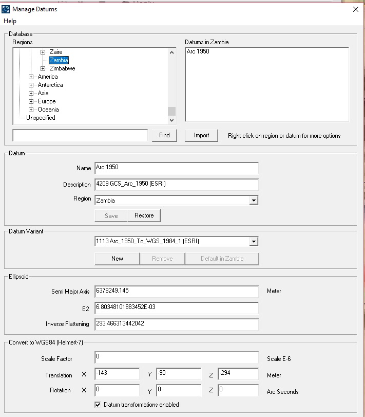
above is a screen shot of the parameters for an arc 1950 datum that id like you to make a geoid file out of for me.
thanks a lot, let me see how it fares
Hi eichhornk,
The left picture represents projection definition and transformation parameters from NAD83 to NAD83(2011) just in case your base in in NAD83, picture to the right account for situation if your base in on NAD83(2011). All lenear units (in both cases) had to be converted to US Survey feets, this included a,b, tX, tY, tZ, falseN, falseE.

you can copy and paste parameters bellow (the is an error in left picture in falseN … field, please use bellow numbers - they are correct)
For the left picture:
USft
20925604.47417 20855444.88384
3.25928 -6.24444 -1.72752 1.00000000171504
0.02591467 0.00942645 0.01159935
20925604.47417 20855444.88384
820208.3330000002 328083.333 37.5 -85.66666666666667 0.999966667
For the right picture
USft
20925604.47417 20855444.88384
0 0 0 1
0 0 0
20925604.47417 20855444.88384
820208.3330000002 328083.333 37.5 -85.66666666666667 0.999966667
I wanted to verify myself, i went to this page NAD83 / Indiana East (ftUS): EPSG Projection -- Spatial Reference In top right corner there is example of transforming BL to NE, I used right picture params and I got the same results:
Unfortunately I do not support file format of the geoid you specified, I will try to add it, as it is more accurate than egm2008, but it will take a long while ← This is not the case anymore I just looked at the GEOID12b files and found them to be almost identical to mine, I will do my best to include GEOID12b in next release 1.26
Just realized that I need to put more decimal places for USfeet, currently I have 3, will change to 4 in next release.
Regards,
RTNFriend
please try fileI linked to, if it does not work I will try to figure something out, Wii probably put geoid correction parameter in settings, if the deviation is constant. (egm2008 is given in relation to WGS84 datum, hopefully you RTK network is internally on that datum or the one close to it)
thank you
Hello
RTN FRIEND
Many of the majority have bought a couple of reaches + Rs; Your application for users without a video of how to use it when we fear two reach, is somewhat confusing, how to configure on the base and how to configure the cost of your application in the rover is the least if you help us with a video in detail we will have this option
yes, it is quite confusing…also note… there is a subscription fee for the app after a trial time I noticed.
Hi,
The app is free for two month (I may increase it to 3) after that it is 13$ per six month subscription. I warned about that in my very first post, but that was edited off by staff (I think they wanted me to look as good guy ;). I do hope my app offers way more that it is asking for.
I would love to make videos but I do not have Reach RS receivers, I had one for a week this spring to adapt into my app an that was it.
RTNFriend is primarily designed for use with RTK Network rovers, So it is assumed Reach RS is used as network rover. There is great reason to use it this way: because many RTK network capable to generate Virtual Reference Stations. What it means is that your vectors to base are always short (this is important for L1 only receivers), so the Reach initializes quick and reliably, you do not have to worry about establishing control network for your RTK work. Recently Reach receivers started to resolve ambiquities on GLONASS when used with non-Reach base, such as VRS or any other real base, I believe that shortens initialization time.
I you have Reach base + Reach Rover that is different story, the app is not designed to setup Reach base, and LORa radio link configuration, you would have to do it by yourself via Reach WiFi interface. Once the Rover is receiving base data of course my app can be used with rover, in this case only External RTK Receiver Connect button should be pressed, Base button should not be pressed as the receiver is already receiving base data via its internal radio. (Internet is not needed in this case). Of course base has to be setup on a known points, otherwise Static control has to be established before doing any RTK job. SurvCE can do RTK site calibration, RTNfriend does not do that yet, but you still need known points around.
Let me know if you have any questions/suggestion this always makes app better.
Thank you.