


Hi,
I wrote a data-collection app for android which has been tested with Reach RS receiver, If you would like to try it is here and the manuals are here. The app allows to define custom user coordinate systems (to use with Reach RS) but it is a metric app, and it projects to Transverse Mercator only so not much of a diversity in this regard…
4 Likes
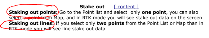
I got it installed already  Haven’t used it yet though I want to draw everyone’s attention to two important features. Here is a screenshot from the manual. Point stakeout and Line stakeout. Good job!
2 Likes
Thank you I will look at it.
Does this app work when I have my reach base sending correction on the internet with youcors and my rover receiving the correction through ntrip?
I responded via email but I am not sure whether the message went through or not… You can still use the app, just do not connect to youcors base from the app, connect to the rover only. Thank you. Let me know what country are you from and I will make geoid file, so you can get elevations above sea level with ReachRS.
Thank you. I will look at the app. I am in Canada
…geoid can be downloaded from here. It has to be placed in RTNFriend folder on your Android device. In the next app release most geoids will be downloadable from within the app.
Thanks a lot. And sorry for too many questions. Does your app allow custom local or ground coordinate systems or is it only wgs84?
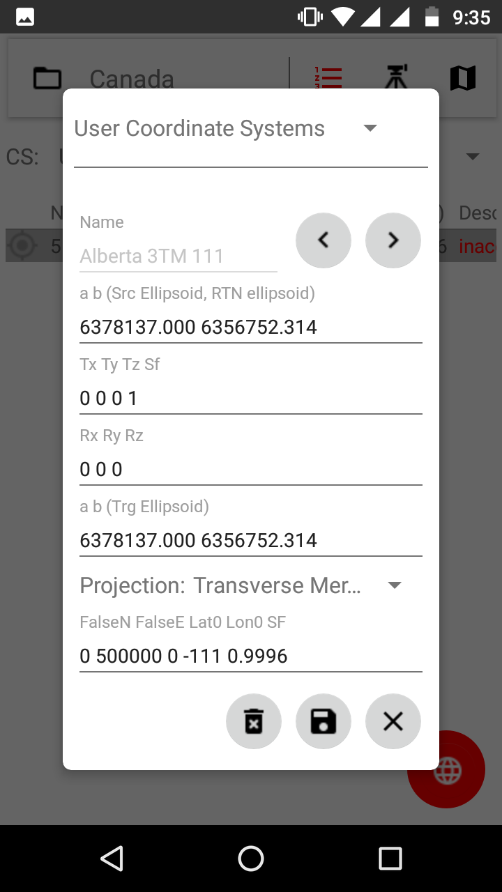
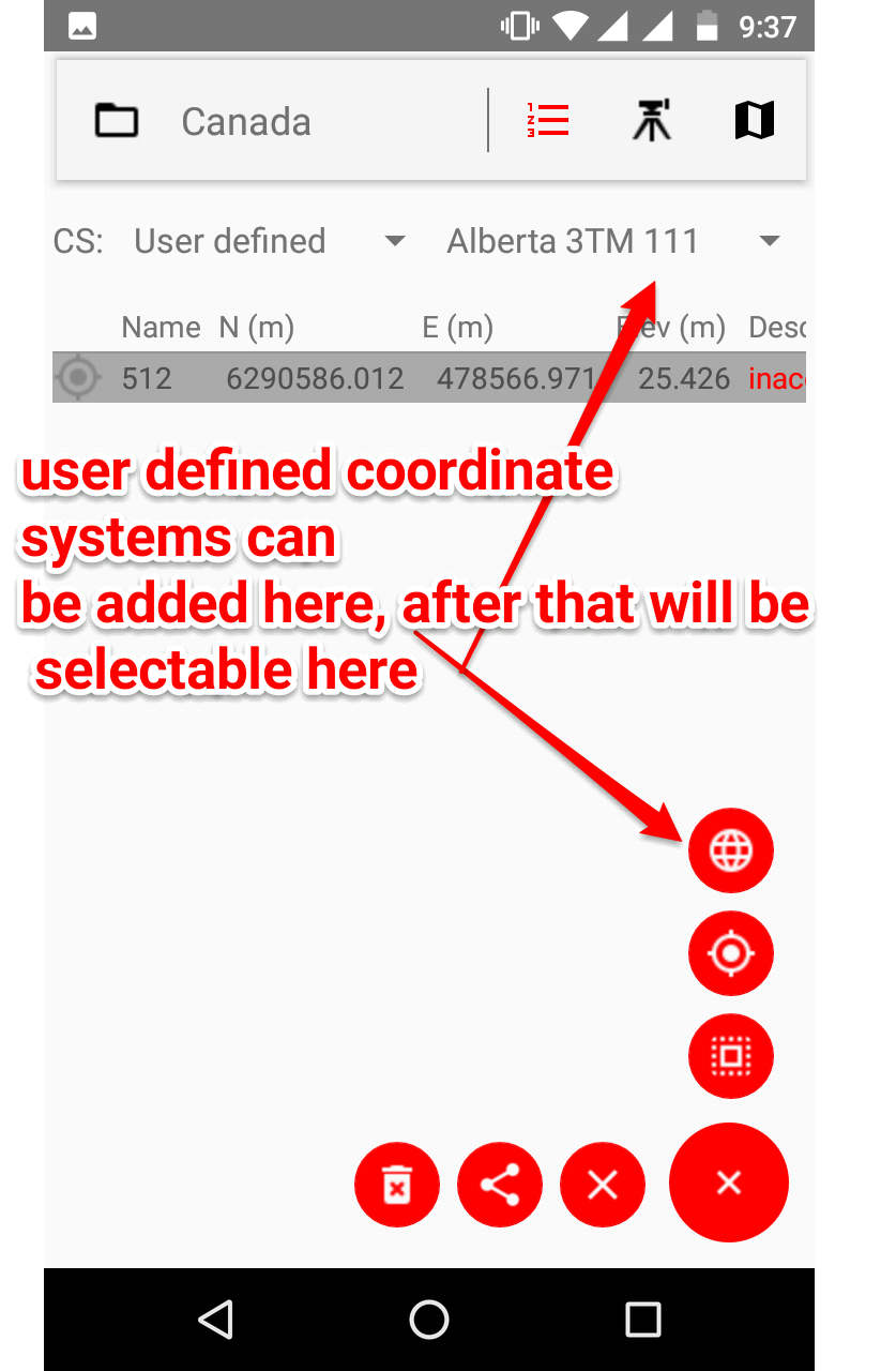
That is ok , I want questions, do not hesitate to ask more !. Custom user defined coord systems can be added (based on Transverse Mercator projection), in the example bellow I put 3TM system for Alberta with central meridian 111W degrees. This is just an example I did not verify this, but this should work. Note this assumes no datum transformation so Helmert translation and rotation parameters are set to 0. which means RTK network datum is the same as user datum. (Once the coord system is added you can import points in that system from a file or key them in manually.)
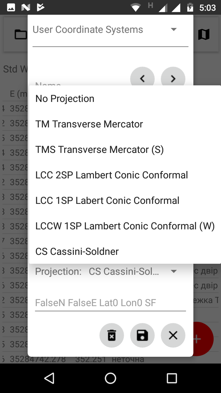
(I am currently adding Lambert Conformal Conic 2SP projection to be user customizable, and plan to add more projections)
Thanks this is a great app. I think it will help me in what I need to do. And I will ask more questions and will share my use of the app once I get things up and running. Thank you
if you let me know what coord system you need I can try to define it… anyways feel free to contact me.
The project I am doing is to setup the gnss system that will be used in Namibia using the Namibia LO system which is gauss conformal. Here is the information about the coordinate system maybe you can help me to set it up in your app: the latitude of origin is 17 and longitude of origin is 22 scale factor is 1 and the false northing and eastings are 0,0
The Namibian Map System
LO (Gauss Conformal)
Bessel 1841 (Schwarzeck Datum)
variable E 13,15,17,19,21
S 22
1.0
0.0
0.0
The Schwarzeck Datum consists of the Bessel 1841 Spheroid tied to a point called Schwarzeck located at 22º 45’ 35".820 S and 18º 40’ 34".549 E. Furthermore it comprises the ‘German Legal Meter’ instead of the international meter (1 GLm = 1.0000135965 SIm).
The transformation from the Schwarzeck datum into WGS 84 implies X, Y and Z shifts but no rotation. DMA – NIMA and Prof. Charles Merry from the University of Cape Town do give shift values, from which the latter ones are the more accurate:
Bessel Spheroid:
a = 6377397.1550 &”German legal”; meter
b = 6356078.96325 ”German legal” meter
a = 6377483.865 intern. meter
b = 6356165.383 intern. meter
f = 1/299.1528128 (no changes due to length unit)
= 0.003342773182
X, Y, Z shifts in meter
DMA –; NIMA 616 (± 20) 97 (± 20) -251 (± 20)
C. Merry (UCT) 616.80 103.30 -256.90
On the Maps in the LO system you will find the positive X axis to the south and the positive Y-axis to the west. This is a left-handed Cartesian co-ordinate system, whilst the computer thinks in a right-handed system. For the display of gridded data just use the normal co-ordinate system but be careful with the grids origin. Some software allows taking care of this by giving a negative central scale factor.
I am a bit busy now, will definitely look at it over the weekend. Good thing is that Gauss Conformal == Transverse Mercator == Gauss Kruger, so the app supports the projection. sorry about delay.
Its okay. I am looking forward to hearing from you after the weekend
… this is South Oriented Transverse Mercator projection. My TM is based on EPSG method code 9807 and I thought it will be easy to modify it to point South and West … but this is not the case at all, now I have to implement entire method 9808, and this is going to take week or two (unfortunately have other things to do), sorry about that.
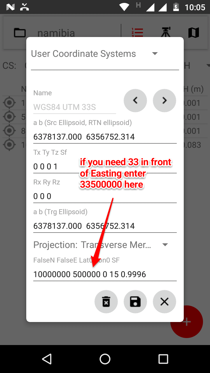
I could use the UTM and them do the transformation of the coordinates into the LO system. Can you do the UTM coordinate system for Namibia?
Here is the UTM system i need. http://georepository.com/crs_32733/WGS-84-UTM-zone-33S.html
Hi mrutjani,
a few important things first:
- I have just published new RTNFriend version 1.22 please update to it as soon as it is available.
- I built a new geoid model for Namibia, if you already have file egm2008na.dat in RTNFriend folder on your android device please delete it and download new geoid version as shown bellow

-
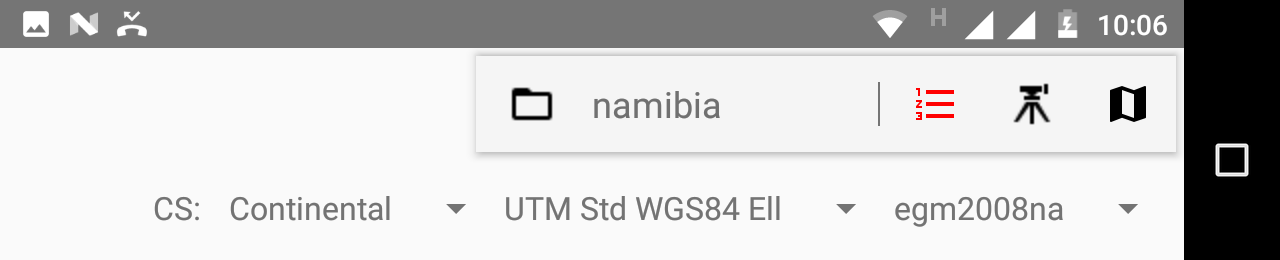
For UTM 33S you can simply select:
-
But, it is better to define coordinate system by yourself -> just in case your RTK network in Namibia is not sitting on WGS84 datum exactly, it is possible to adjust, “to fine tune”, to WGS84 datum but setting small “corrections” Tx Ty Tz Rx Ry Rz Sf parameters, now they are set to sero so you will get same coords as in tep 3
( You can also enter coordinates manually or from a file at stem 4, this is not possible in step 3 <- will fix that in next release)
I will try to add south oriented TM and will let you know once it is available, need some time for that.
with kind regards,
rtnfriend
It took some time… finally added South Oriented Transverse Mercator projection which ca be customized by users. Please update the app to v 1.23, just published it, so it may take a few hours before it is on Google Play.
Bellow are settings for Naminia L0 system. Please note it includes transformation from WGS84 to Schwarzeck Datum. It would be great if you try it out and let me know how everything goes. For transformation parameters, system definition I used this reference
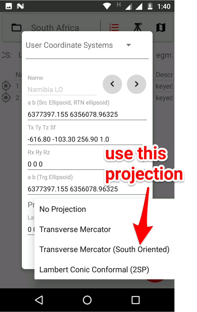
Sorry, I am updating the second picture, found a mistake, forgot to convert WGS84 ellipsoid axes to German legal meter, the correct parameters are:
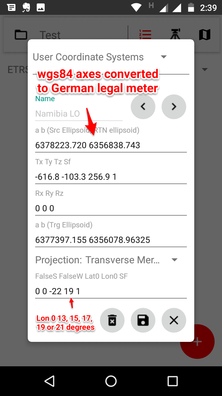
Just fixed an error when FalseS FalseW was not showing up, when user reviewed his defined coord system. Please use version 1.24
Regards,
RTNFriend
Hi,
I just wanted to let know that I added a few more projections, user coordinate systems can be defined in any linear units.
There are Geoid models for entire Europe, USA, Mexico, Brazil and some more countries, Geoid models can be downloaded and used from within the app. Which means you can get elevations above sea level with ReachRS receiver. Please note that Ellipsoidal Heights you are getting from the receiver are not elevations above sea level.
Let me know if you have any questions,
With kind regards,
RTNFriend.
1 Like